How does Utah’s water supply look?
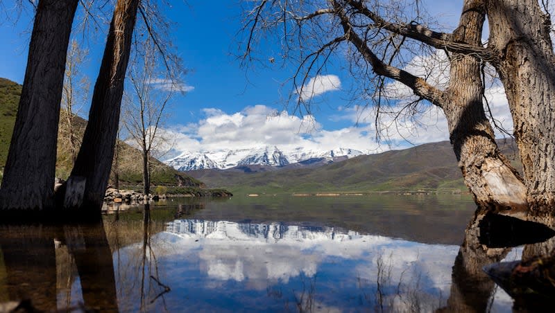
The latest water supply report for Utah released earlier this week puts statewide reservoir storage at 87% capacity, the fullest the reservoirs have been since June 2020.
In fact, Deer Creek Reservoir is a whopping 99% full and even Strawberry, the largest reservoir completely within Utah, is holding more than a million acre-feet of water and is just over 95% full.
Jared Hansen, the Central Utah Project manager for the Central Utah Water Conservancy District, said Strawberry will fill this year, which will be only the third time in 50 years.
“We are pretty excited to fill it,” he said.
The Utah Snow Survey report put out by the USDA’s Natural Resource Conservation Service said reservoir storage is up 30% from this time last year, and these systems still have to make room for the coming snow melt — including what was delivered in the wild storm that hit in early May.
“As noted last month, with a couple exceptions we anticipate that most of Utah’s reservoirs will fill soon, if they haven’t already. That said, who knows what the future will bring,” stated snow supervisor Jordan Clayton in summary of conditions as of May 1.
He cautioned, however, that residents need to remain vigilant over their water use.
“We encourage Utahns to continue to conserve water to help keep as much water in our reservoirs as possible moving forward, to provide a buffer against possible below-normal water supply conditions next year and beyond.”
Clayton compared this snowpack season to the mellow younger sibling of last year’s.
“Both winters provided well above-normal snowpack totals for the state. In fact, Utah hasn’t experienced two consecutive winters this far above normal since 2005-2006. Both last year and this year our snowpack peaked in early April after three consecutive months of above normal accumulation,” he said.
How wet is wet?
Clayton said as of May 1, all of Utah’s major watersheds were 90% of normal precipitation or above for the 2024 water year, with the northern Utah basins faring the best.
As the snowmelt progresses and makes its way to the ground, that boosts saturation and soil moisture conditions.
“Our statewide soil moisture is at 83% of saturation, which is quite close to a record maximum. As noted elsewhere, high soil moisture levels promote efficient runoff, leading to a larger proportion of snow water reaching downstream reservoirs,” he said.
Utah’s snowmelt runoff forecasts for April through July flow volume range from 160% to 35% of average, the release noted.
The Bear, Weber, and Provo basins in particular are far above to well above average flow, compared with close to average forecasts for the Duchesne and San Pitch basins, below average forecasts for the Eastern Uintas and south-central Utah, and below to well below average forecasts for the Sevier Basin and the southwestern and southeastern corners of the state.
Clayton noted that people can check out the National Oceanic Atmospheric Administration’s Colorado Basin River Forecast Center’s Peak Flow Forecast map which combines current conditions with projected streamflow levels, expressed in percentiles. The projections do not include information about flood potential, but rather provide an estimate of the overall volume of water that will pass by a particular stream gauge from April through July.
How is the Great Salt Lake doing?
The amount of water in snow that is part of the Great Salt Lake Basin and the precipitation that fell as of May 1 ranges from 108% to 115% of normal.
Additionally, the amount of available reservoir capacity in basin reservoirs — which is very little — will likely lead to significant inflows into the struggling lake with a forecast into July that ranges from 245,000 acre-feet to 855,000 acre-feet. Clayton said the most probable outcome is 550,000 acre-feet.
The lake has already risen 3 feet since October and will likely gain another half foot with the runoff, but Clayton cautioned that there is uncertainty built into the predictions.
“We remind our readers that our inclusion of GSL inflow forecasts and predicted lake level rise is meant to provide rough guidance for Utah’s water managers in light of the high level of interest in the lake’s condition and numerous actions to restore lake levels,” he said.
Nevertheless, more water means less exposed lake bed and thus less dust likely to be whipped into the air and scattered throughout the Wasatch Front.
The nexus between the levels of the Great Salt Lake and dust was a topic of discussion this week at the Great Salt Lake Forum hosted by Friends of the Great Salt Lake. The panel on dust included a variety of experts discussing shared goals, ways to manage or counter the dust and reflections on lessons learned so far.
In 2023, the Utah Legislature approved $232,000 for new dust monitors to be placed in strategic locations around the Great Salt Lake to gather data.
The dust is a public health concern because it is laden with toxins that include arsenic, lanthanum, lithium, zirconium, copper and other metals which breach EPA’s standards.
Kevin Perry, a University of Utah professor of atmospheric science, has seen the dust firsthand, exploring the 800 square miles of exposed lake bed.
A study by researchers at Brigham Young University, the University of Utah and Middlebury College in Vermont was the first of its kind to do a chemical analysis and comparison of playa dust and urban dust in the Western United States. The results?
The study found that 90% of dust along the Wasatch Front and in Logan comes from dried up lake beds and desert basins.
In addition to the new report by the Utah Snow Survey, it is announcing that on its homepage there a new link called: “How is your favorite Utah basin doing?” These are basin pages for all of Utah’s major watersheds which are meant to serve as landing pages for anyone interested in a certain area so that they can find out all of their basin’s conditions. The direct link can be found here.

