A foot of rain may fall in the Washington, D.C., area by Friday
2016 is turning out to be the year of the flood, at least in the U.S. Most recently, there were the Louisiana floods, which caused more than $1 billion in damage and displaced tens of thousands of people. Before that, there was the violent flash flood in Ellicott City, Maryland, and the deadly flood in West Virginia in June.
Now weather forecasters are warning of a potentially dangerous scenario already beginning to unfold across the Mid-Atlantic states. Both Washington, D.C., and Baltimore are in the crosshairs for this system, with as much as 5 to 8 inches or more of rain likely to fall through Friday.
Higher amounts, possibly as much as 10 to 12 inches of rain, are within the realm of possibility from this weather pattern.
SEE ALSO: Climate change poses a major security risk to the U.S. today, intelligence report warns
In fact, short-term forecasts show that up to 8 inches of rain may fall along the I-95 corridor on Wednesday night and Thursday morning, with still more rain to come after that.
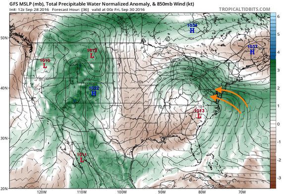
Image: tropicaltidbits.com/mashable
A low pressure area in the upper levels of the atmosphere will set up residence just to the west of the Mid-Atlantic, with a moist southeasterly air flow out ahead of it transporting an unusually moist air mass off the Atlantic Ocean and into the Mid-Atlantic.
The air at mid-to-upper levels of the atmosphere will be diverging above the Mid-Atlantic, which encourages air to rise, cool and condense to form clouds and precipitation. Forecast models are showing sustained lifting of an increasingly humid air mass from Wednesday through Friday.
Excessive rainfall outlook for the next couple of days. Be prepared for possible flash flooding in these areas... especially the red. pic.twitter.com/bpqr4wyLIz
— NWS MARFC (@NWSMARFC) September 28, 2016
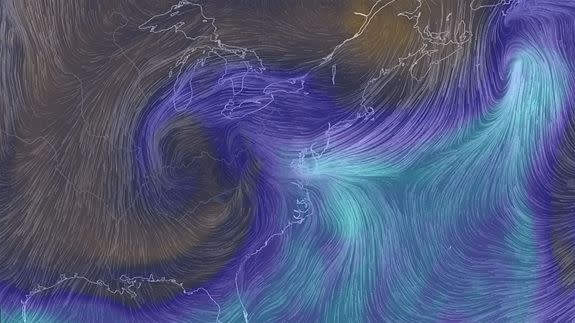
In fact, the moisture will be so abundant that it can be thought of as the East Coast's version of an atmospheric river, which are a phenomenon more frequently seen in West Coast storms.
Here's how the Washington Post's Capital Weather Gang blog describes the forecast for its large readership:
The winds coming off the Atlantic will form a strong current known as a low-level jet, at an altitude of about 5,000 feet.
The total transport of water vapor from the Atlantic Ocean to the Mid-Atlantic will yield an air mass that more closely resembles what might expect in a tropical storm or hurricane, with extremely high moisture levels that can be wrung out of the air as torrential rainfall. Total water vapor transport will be about three standard deviations above average, according to the National Weather Service.
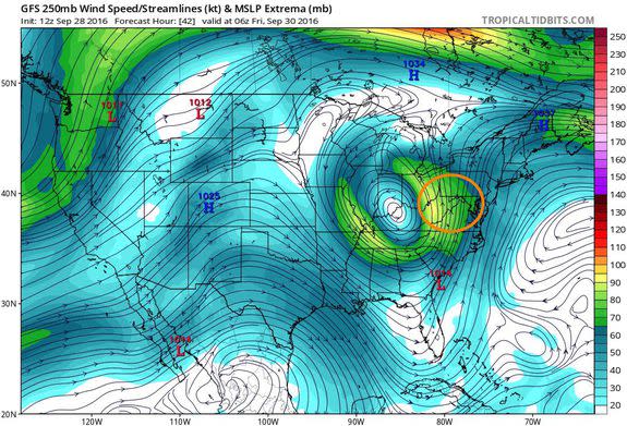
Image: Tropicaltidbits.com/mashable
Part of the reason there will be so much precipitable water for this storm is the fact that sea surface temperatures off the Mid-Atlantic coast are still running much higher than average for this time of year.
Severe flooding possible from a powerful storm! Image shows what to expect, what to do. Please share! #mdwx #vawx #dcwx #wvwx pic.twitter.com/EAlyU96cdE
— NWS DC/Baltimore (@NWS_BaltWash) September 28, 2016
It's difficult for meteorologists to pinpoint which areas will receive the highest rainfall totals, although one bulls-eye appears to be along the mountains northwest of Washington. Here, winds flowing up and over the high terrain will enhance rainfall rates.
However, stalled frontal zones and other factors could result in surprises, including much higher rainfall totals across the Interstate-95 corridor.
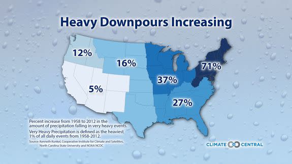
Image: climate central/ncsu/ncdc
Because this region has been relatively dry during the past few months, flooding will be a threat once rainfall passes a particular threshold (around 3 inches in 6 hours or less in some places, a bit more in others).
Flooding will also depend on rainfall rates, with a longer period of steady rains minimizing the threat of flash flooding but raising the possibility of small stream and river flooding.
As in many other areas, heavy precipitation events in the Mid-Atlantic region have been on the rise in a trend linked to human-caused global warming. As air temperatures warm, more water vapor is available for storm systems.
In addition, higher ocean temperatures also boost water vapor, which further adds to the precipitation potential of a storm system.
