Hurricane Matthew could damage the U.S.' newest weather satellite before it launches
Even deadly hurricanes appreciate irony once in a while. Lying directly in the path of fearsome Hurricane Matthew, which could become the first Category 3 or stronger hurricane to strike the U.S. since 2005, is America's next-generation, $1.2 billion weather satellite.
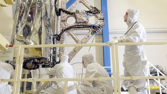
The spacecraft, known as GOES-R (GOES stands for "geostationary operational environmental satellite"), is sittiing in a clean room at a building in Titusville, Florida, which is on the state's northeast coast, across the Intracoastal Waterway from Kennedy Space Center.
SEE ALSO: The 3 potential paths that Hurricane Matthew will follow
Some computer models are projecting that the storm may make landfall directly over Titusville and nearby Cape Canaveral, and a hurricane warning is in effect there.
It's within the realm of forecast scenarios that the storm could be a high-end Category 4 or even a Category 5 storm if and when it hits that area.
At Astrotech in Titusville, teams building tent over NOAA's GOES-R satellite as extra protection against approaching #hurricaneMatthew. pic.twitter.com/pJTtX8m1Ix
— James Dean (@flatoday_jdean) October 4, 2016
The satellite, which is the first in a $10.9 billion series of four satellites, is scheduled to launch into space on Nov. 4, with NASA and the National Oceanic and Atmospheric Administration (NOAA) heralding the event as a milestone in U.S. weather forecasting efforts.
The NOAA in particular is counting on GOES-R to begin to prevent a dangerous gap in America's weather satellite coverage, given the country's aging platforms now in orbit, as well as to boost the nation's capabilities for next-generation weather and climate data gathering.
According to NOAA spokesman John Leslie, the satellite is at relatively low risk of being damaged by the storm, provided it does not exceed Category 4 intensity.
"In advance of Hurricane Matthew’s potential path to Florida’s east coast, the team preparing NOAA’s GOES-R spacecraft for launch has taken appropriate safety measures to secure the satellite at its present location — Astrotech Space Operations in Titusville, Fla.," Leslie said in a statement to Mashable.
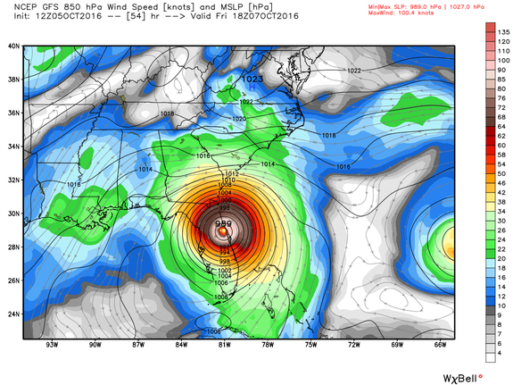
Image: weatherbell analytics
"GOES-R is contained in a building that can withstand strong (Category 4) hurricane conditions. After the effects of Hurricane Matthew subside, NOAA and NASA will carefully assess the spacecraft and provide an update on its status."
The aerospace giant Lockheed acquired Astrotech in 2014.
NASA's facilities at the Kennedy Space Center were similarly built to withstand a direct hit from a hurricane, though studies show the facilities are vulnerable to sea level rise and storm surge flooding, which is a threat with Hurricane Matthew.
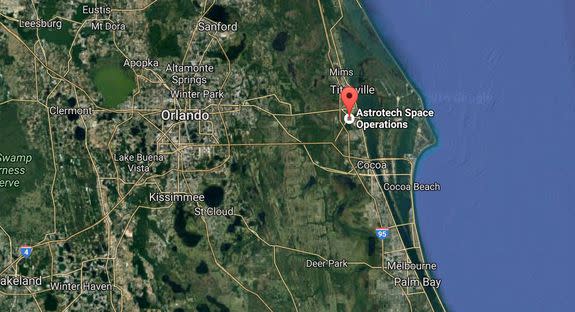
Image: google maps
As of Wednesday at 5 p.m. EDT, the National Weather Service was forecasting the risk of 5 to 8 feet of inundation above ground level at Cape Canaveral if the storm were to hit at high tide.
The facility housing the GOES-R satellite, which has not yet been mounted to the rocket that will deliver it to orbit, does not sit at the water's edge and therefore has a lower storm surge risk.
Several of the older NASA buildings which are of more historical value than critical infrastructure for satellite launches are only rated to withstand a Category 3 storm.
Should the storm move farther northeast than currently anticipated and affect the NASA facility in Wallops Island, Virginia, then Hurricane Matthew will have pulled off a rare feat by hitting a satellite before it is deployed, and then striking the ground control system that will communicate with the satellite and receive data from it while it orbits the planet.
The satellite dishes and other equipment at Wallops Island were designed to withstand winds of up to 150 miles per hour, according to a spokesperson for the Harris Corporation, which built the equipment.
Assuming it is successfully deployed, the new satellite, for example, will provide unprecedented monitoring capabilities for global lightning activity and allow faster, more frequent imaging of storm systems that could significantly improve severe thunderstorm and even hurricane forecasts, among other advances.
