Minor river flooding closing some Des Moines streets, parks
After Iowa received more rain and severe weather Monday night, the National Weather Service Des Moines issued flood warnings in the metro area.
Flood Warning issued for rivers in Iowa
NWS Des Moines issued flood warnings for the following locations in effect Tuesday morning through Wednesday afternoon:
Des Moines River at Southeast Sixth Street in Des Moines
Raccoon River at Fleur Drive in Des Moines
Minor flooding is expected, and NWS encourages residents to take precautionary actions, like monitoring river and stream observations at water.noaa.gov.
How much will rivers flood in Des Moines?
The Raccoon River at Fleur Drive and the Des Moines River at SE 6th Street in Des Moines are both forecast to go into minor flood stage late this evening. pic.twitter.com/SLbarmmtcA
— NWS Des Moines (@NWSDesMoines) May 7, 2024
At 6:45 a.m. on Tuesday, the Raccoon River was at 11.2 feet, about a foot below flooding levels. Levels are expected to rise above 12 feet late Tuesday evening, just after midnight.
The Des Moines River at Southeast Sixth Street is 23.2 feet as of 8 a.m. Tuesday. It is expected to rise to 24.3 feet or 0.3 feet above flood stage. Portions of the trails in the area may be closed.
NWS said rivers will fall back below flood stage late Wednesday morning.
Water Works Park, George Flagg Parkway closes for flooding
Des Moines Water Works has closed the back half of Water Works Park due to high water.
Des Moines Water Works has closed the back half of Des Moines Water Works Park. The city of Des Moines will close George Flagg Parkway from 30th Street to Park Avenue after the morning (Tuesday) commute. These areas are closed until further notice. pic.twitter.com/xXyiTDE509
— Des Moines Water Works💧 (@DSMH2O) May 7, 2024
George Flagg Parkway is closed from Park Avenue to SW 30th Street as well.
What trails in Des Moines are closed due to flooding?
Neal Smith Trail: 6th Avenue to Birdland Marina
Bill Riley Trail
Grand Avenue Bridge along Walnut Creek
Principal Riverwalk: Bottom river trail sections between Water Street and Locust Street heading north, and from Rotary Riverwalk
Flooding at Jester Park Nature Center, Saylorville Lake rises
Jester Park Nature Center said on Facebook that there is flooding at the park. The Lincoln boat access to Saylorville Lake and campground there have been closed. The park said they will continue to monitor the water.
High water at Saylorville Lake is causing debris warnings and closures. Closed areas include:
Cherry Glen Lower Boat Ramp
The lower parking lot at Lakeview High Water Boat Ramp
Oak Grove Beach Access
NW Jester Park Drive
These closures will remain in effect until lake levels recede, and areas can be safely cleaned. In a news release, officials from Saylorville Lake said visitors should be mindful of limited parking availability and potential hazards, including submerged structures and floating debris in the lake.
The U.S. Army Corps of Engineers are forecasting Saylorville Lake to reach up to 855 feet by May 14, which is the highest it's been since 2019. Normal levels for the lake are around 836 feet. The lake is expected to stay below the flood level of 890 feet.
How much rain has Des Moines had?
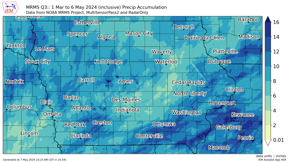
Since March 1, Des Moines has recorded 6.1 inches of precipitation. That's about 1.1 inches below normal, but almost 2 inches higher than the same period in 2023.
Victoria Reyna-Rodriguez is a general assignment reporter for the Register. Reach her at vreynarodriguez@registermedia.com or follow her on Twitter @VictoriaReynaR.
This article originally appeared on Des Moines Register: Minor river flooding closing some Des Moines streets, parks

