
Tornado Alley to roar back to life as dangerous stretch of severe storms on the way
After a relatively calm period of severe weather at the end of last week and the beginning of this one, Tornado Alley is poised to come back to life with a multiday severe weather event starting Thursday and continuing through the weekend.
Multiple disturbances will emerge from the Rockies and bring dangerous rounds of severe storms to the Plains and Mississippi Valley, which is typical as severe weather often peaks in these areas from late April through May.
A few strong to severe storms capable of producing large hail and strong wind gusts will form along a dryline on Wednesday in parts of West Texas and Oklahoma, but these will merely serve as an appetizer to the main event, which begins Thursday.
The southern and central Plains appear to be the target Thursday, and NOAA’s Storm Prediction Center (SPC) has placed that region in a Level 3 out of 5 risk on its 5-point severe thunderstorm risk scale.
The setup on Thursday, however, is different from previous severe weather outbreaks last week.
The FOX Forecast Center said an upper-level disturbance will move into the Southwest by early Thursday. As that piece of energy approaches the central U.S., an area of low pressure will form at the surface and fuel the development of rain and thunderstorms.
Thursday’s severe weather threat extends from south-central Nebraska through central Kansas, western and central Oklahoma and northwestern Texas.
Wichita in Kansas, Oklahoma City and Norman in Oklahoma and Lubbock and Wichita Falls in Texas all face the risk of severe weather on Thursday.
The SPC said a few supercell thunderstorms could develop and will be capable of producing large hail, damaging wind gusts and even a few tornadoes.
NEW SUMMER WEATHER OUTLOOK LOOKS TOASTY ACROSS MUCH OF US AS JUNE LOOMS LESS THAN 50 DAYS AWAY
The severe weather threat will then pivot to the eastern Great Plains and the mid-Mississippi Valley by Friday and will expand in coverage.
Eight states from Texas to Iowa will be in a Level 2 out of 5 risk, which includes major cities like Dallas and Waco in Texas, Oklahoma City and Tulsa in Oklahoma, Kansas City and Springfield in Missouri and Des Moines in Iowa.
Large hail and damaging wind gusts will be some of the threats associated with thunderstorms that develop. However, the threat of tornadoes may be a bit higher than what is expected on Thursday.
The severe weather threat will again target the southern and central Plains and the mid-Mississippi Valley on Saturday, with portions of North Texas, most of Oklahoma, central and eastern Kansas and western and northern Missouri seeing the highest risk of storms for the first part of the weekend.
The SPC said that daytime heating will allow for storms to develop, and those storms could continue as we get into Saturday evening.
A storm system is predicted to move from the central Plains toward the Great Lakes region on Sunday, bringing a risk of severe thunderstorms from the Ark-La-Tex region to parts of the Midwest.
Changes are expected with the forecast, however, as computer forecast models continue to analyze data. Be sure to download the free FOX Weather app and enable notifications to receive important weather alerts and monitor changes to the forecast.
April's tornadic activity has been above average with 184 reports this month.
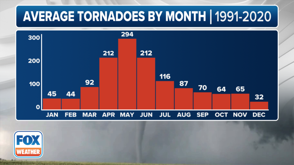
May is typically the most active month for tornadoes with an average of 294 twisters, according to the latest historical data from the SPC.
In 2024, the center has received 347 reports of tornadoes, which is more than 10% fewer than an average year to date.
"This past week really solidified us with above-average activity," FOX Weather Meteorologist Jane Minar said. "And when you take a look at the month of April, where you typically see tornadic threats, it's more back off through the Plains. So you look into, say, Texas, portions of Oklahoma, even into parts of the Southeast, the Mississippi River region, but we've been seeing much more activity, you know, up across the Ohio Valley. Ohio leads the country with the number of tornadoes."
Severe weather outbreaks are more common during La Niña events than in El Niño or neutral episodes.
Several climatological organizations consider the Pacific Ocean to be in a neutral status of the El Niño-Southern Oscillation, or what is commonly referred to as the ENSO.
Original article source: Tornado Alley to roar back to life as dangerous stretch of severe storms on the way

