Mysterious Pumice Raft in Pacific Explained

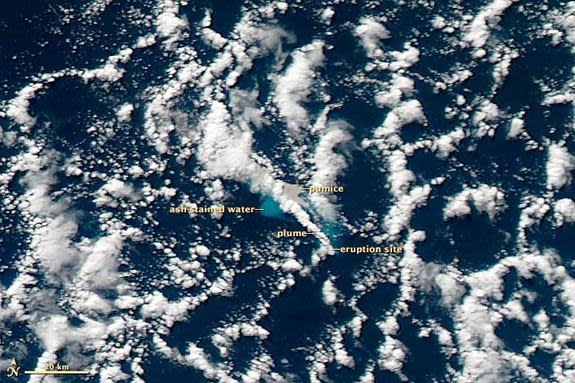
Back in August, an enormous floating mass of pumice was spotted in the South Pacific Ocean off the coast of New Zealand. New evidence of changes on the seafloor confirms an erupting undersea volcano created the sprawling rock raft.
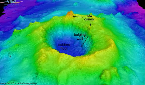
New Zealand scientists aboard the research vessel Tangaroa recently mapped the underwater volcano, Havre Seamount, which erupted on July 19 and was thought to have sent pumice rocks floating over a stretch of ocean 8,500 square miles (22,000 square kilometers). Now, the scientists say they detected a new volcanic cone — a feature built during an eruption — at Havre Seamount, reaching within 3,600 feet (1,100 meters) of the surface.
(Pumice forms when volcanic lava cools quickly. Gas gets trapped inside as the lava hardens, resulting in porous lightweight rocks that can float.)
Fluffy white stuff
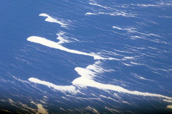
On Aug. 9, the HMNZS Canterbury ship observed the floating pumice "island" — measuring 300 miles (482 kilometers) in length and more than 30 miles (48 km) wide. The floating fluff apparently "lit up a brilliant white color" under a spotlight, "like the edge of an ice shelf," said Lieutenant Tim Oscar, a Royal Australian Navy officer, in a statement at the time. [See Photos of the Pumice Raft & Volcano]
The researchers from New Zealand's National Institute of Water and Atmospheric Research (NIWA) aboard Tangaroa are currently on the last leg of their 23-day voyage to study the Kermadecs, a volcanic island arc north of New Zealand. Their findings, along with an analysis of satellite images, make a pretty sealed-tight case for the pumice culprit.
They had previously mapped this undersea volcano in 2002 using a so-called multibeam echosounder, so they could compare those images with the recent ones taken this month. (The angle and travel time of the initial sound waves sent out allows scientists to create an image of the seafloor.)
They found these new volcanic cones, or miniature versions of the larger volcano, one towering at 787 feet (240 meters), on the rim of the caldera, NIWA marine geologist Joshu Mountjoy told LiveScience.
"The new map shows that the internal wall of the caldera now has up to 180 meters [590 feet] of lateral 'bulging' indicating the location of future eruption, or wall collapse," Mountjoy added.
Their analysis also suggests two magma types were involved, an explosive type called rhyolite that shot pumice up to the ocean surface, and a less volatile one that settled out to build the new volcanic cones.
"The rhyolite had high volatiles, much as a can of soda is full of carbon dioxide, so when it was shaken up and the pressure released on eruption (like opening the tab on the soda can) the magma came out violently and explosively, leading to ash and pumice that went from about a mile below sea level into the atmosphere," NIWA volcanologist Richard Wysoczanski wrote in an email to LiveScience.
The geochemistry of fresh samples of pumice taken from around the Havre Volcano matched up with that of samples taken from the surface raft, Wysoczanski found.
An undersea shakeup
Here's how Wysoczanski thinks events leading to the vast raft went down: Sizeable earthquakes in the region on July 17 may have shaken up chambers of magma and caused movement of the basaltic magma well beneath the volcano. As it moved toward the surface, that magma would have intersected the rhyolitic, pumice-forming magma.
"Contact between the two magmas would have triggered the eruption leading to an explosive ash and pumice eruption from the caldera floor as well as basaltic magmas being erupted on the caldera rim at the top of the volcano, forming the volcanic cones," Wysoczanski wrote.
The Havre eruption tapered off by July 21, just days after it began, leaving behind the sprawling raft of pumice. Winds and currents have since spread the porous rocks into "a series of twisted filaments," according to the NASA statement. On Aug. 13, the pumice was spread over an area about 280 by 160 miles (450 by 258 kilometers).
And currently, according to NIWA scientists, the pumice is still floating in thin filaments and it will likely take some time for the rocks to totally disperse.
Follow LiveScience on Twitter @livescience. We're also on Facebook & Google+.
Copyright 2012 LiveScience, a TechMediaNetwork company. All rights reserved. This material may not be published, broadcast, rewritten or redistributed.
