
Navigate your way through Apple Maps with three iOS 8 tips

When Apple Maps first launched in iOS 6, there wasn't much fanfare. However, over the years, Apple Maps have increasingly gotten better, more accurate, and easier to use than many other mapping apps available on iOS. In iOS 8, many new features were included that made Maps even better. Cory Bohon takes a look at three tips and tricks in the iOS 8 Maps app.
1. Getting directions to any contact
Sometimes, you may want to use the Maps app to navigate to a contact that you already have on your device's contact list. With iOS, you can easily do this by following these steps on your iPhone or iPad:
Launch the Maps app
Tap on the search field at the top
Tap the Favorites button
Tap the Contacts at the bottom (Figure A)
Locate the contact you'd like directions for, then tap it
Tap the the car icon
Tap on the Start button at the bottom to begin navigation
Figure A
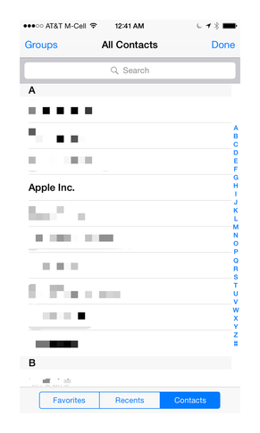
Selecting a contact from this list will let you navigate with only a few taps to the listed address in the contact card.
Note: If you're unable to select a contact, this means that the contact doesn't have an address listed.
2. View 3D areas
Apple Maps includes a very nifty 3D Flyover feature that makes it appear as though you're in a helicopter flying over a particular location. In iOS 8, a new feature helps you to better recognize areas on the map for a particular region.
While you're viewing the map, if you see a round 3D icon (Figure B), then you know this area has the ability to view a Flyover. As Apple expands this feature to more cities around the globe, you'll begin seeing them in more areas on the map. For now, however, you can only use Flyover 3D on large cities and landmarks around the world.
Figure B
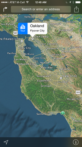
The 3D icon displayed on the Map means the Flyover feature is supported in a particular area.
If you tap on this icon, you'll see a Tour button that lets you easily begin an animated flyover that allows you to zoom into an area and fly around particular landmarks.
3. Getting transit app recommendations
When Apple switched from Google Maps to their own implementation, they discontinued the transit direction feature in the Maps app. While iOS 8 maps still only does walking and driving directions natively, it does offer localized recommendations for transit apps that will help you navigate your way around the transit system for local cities.
To get transit app recommendations for a particular area, follow these steps:
Open the Maps app
Tap inside the search bar, then search for a location
Tap the Car icon on the location on the map
Select the Apps section (Figure C)
Figure C

Tapping the Route button next to an installed app will launch that app to complete the transit directions.
This Apps section will display both installed transit apps and localized transit apps that can handle that route from the App Store. With a single tap, you can open the installed apps or download new apps that can handle the routing for that particular area.
Do you use Apple Maps? What features, tips, or tricks are you unable to live without in the Maps app? Let us know in the discussion thread below.