Could Florida see Tropical Storm Debby? Tropical wave could affect PCB's weekend
There are two different scenarios for where a tropical wave heading west across the Atlantic will go, according to AccuWeather forecasters.
Florida residents should be prepared for either scenario.
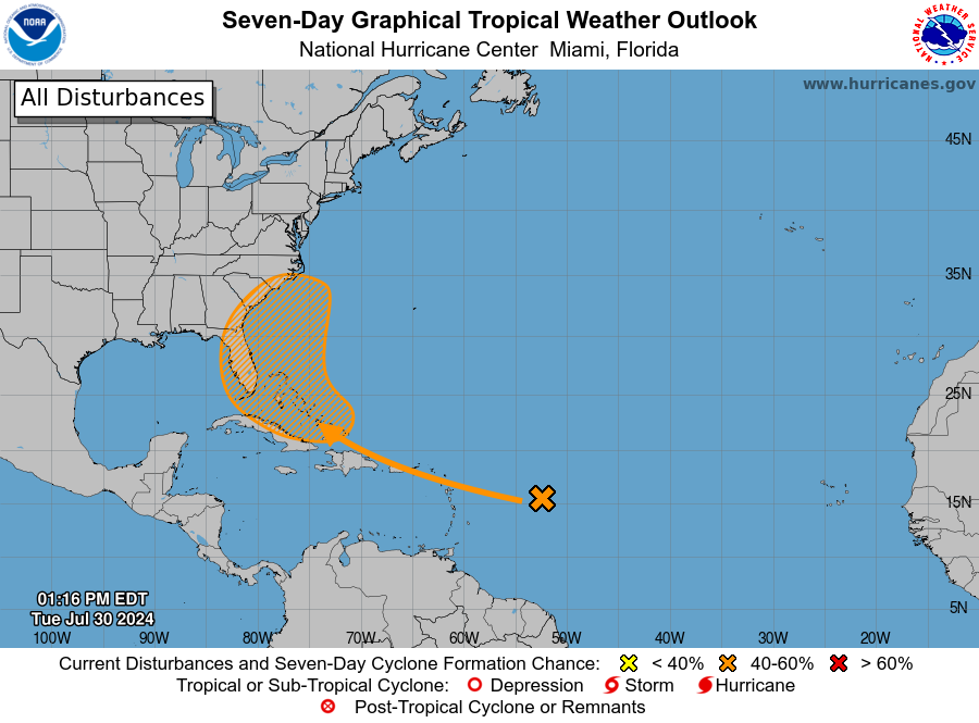
A tropical wave near the Greater Antilles and the Bahamas has a 60 percent chance of development over the next seven days, according to the latest advisory from the National Hurricane Center. A tropical depression could form late this week, NHC forecasters said.
AccuWeather meteorologists — who are calling the system a "developing tropical rainstorm" — said there's a chance it could become a tropical storm, but no sooner than this weekend or early next week.”
If sustained winds reach at least 39 mph, it would become Tropical Storm Debby, the fourth named storm of the Atlantic season.
Tropical wave could become tropical depression this week
Storm tracker: Monitor tropical wave as it moves toward Florida
Where is the tropical wave now and what's preventing it from strengthening?
As of Tuesday afternoon, the tropical wave was near the Greater Antilles and Bahamas, east of the Caribbean Sea, according to the National Hurricane Center.
"It hasn't made much progress over the last couple of days but it is still trucking to the west," said Alex DaSilva, AccuWeather lead hurricane expert.
➤ Tracking the tropics: What you should know in less than a minute
Dry air and wind shear are preventing the system from developing right now and for the next couple of days.
"The story over the next couple of days will be as it moves toward the islands," DaSilva said.
The tropical wave is expected to be on the northern side of Puerto Rico by Wednesday night or Thursday before moving toward Hispaniola.
While no development is expected over the next couple of days, Puerto Rico and Hispaniola can expect rain and rough surf.
Chances for development increase as tropical wave gets closer to Florida, U.S.
"Between Friday and Sunday the wave will be near the Bahamas, and that's where we'll have to watch it because conditions will be more favorable for development as it gets closer to the U.S.," DaSilva said.
"The dry air will wane and there will be a little wind shear but not a whole lot, so conditions will be more favorable for development."
"Don't expect any development over the next couple of days. It would be Friday, at the earliest, to develop into a tropical storm because of the dry air in place," DaSilva said.
2 scenarios and who could feel impact from what could become Tropical Storm Debby
DaSilva said AccuWeather is looking at two different scenarios for the tropical wave:
Scenario 1, a northerly route: If the "tropical rainstorm" takes "a more northerly route, staying north of Puerto Rico and Hispaniola, and doesn't tangle with the islands, then it's like to curve up into the Bahamas. Any development is likely to take it to the Carolinas, or it could stay offshore over the weekend."
Under this scenario, it could get to Florida on Friday or Saturday, either getting very close to Florida or staying just offshore, DaSilva said.
Regardless of development, Florida residents along the East Coast should expect rough surf and dangerous rip currents.
"If it does develop, though, you could see wind and heavy rain.
"As it moves north, it could pass close to the Outer Banks or clip the Carolinas and then head out to sea early next week," DaSilva said.
"I could definitely see it strengthen into a tropical storm under this scenario, and I can't discount a hurricane. Although chances are fairly low for a hurricane, waters are plenty warm."
Scenario 2, a southerly route: If the tropical wave takes a more southerly route and moves very close or over portions of Puerto Rico, Hispaniola and Cuba, that will likely "keep the wave weaker before it pops into the Gulf of Mexico over the weekend or early next week," DaSilva said.
"Once it gets into the Gulf, it could strengthen and head into Florida's West Coast or the Panhandle early next week."
Because of weakening that would occur after interacting with the islands, "it would probably be the weekend or early next week before it could develop into a tropical storm in the Gulf of Mexico," DaSilva said.
Florida's East Coast, or West Coast and Panhandle: Which scenario is most likely?
A northerly track would make the system a concern for East Coast states, including Florida and the Carolinas.
A southerly track is less likely but would make the system more of a concern for the U.S. Gulf Coast.
"Predictions are leaning toward it staying east of Florida, but the door is still open, so people in the Gulf should still watch it carefully," DaSilva said, emphasizing the tropical wave could move into the Gulf and impact Florida's West Coast or Panhandle.
Florida West Coast impact: A tropical wave has a chance of becoming a storm, but will it come to Sarasota, Bradenton?
Gulf Coast impact: Meteorologists warn Gulf Coast residents to keep an eye on developing tropical wave
If it does move into the Gulf, "It's most likely to hook into Florida's West Coast or into the Panhandle."
Could this system undergo rapid intensification?
"Rapid intensification is always on the table but it certainly is expected to become a tropical storm in the Gulf, but since it went over the islands, the center will be disrupted and it'll take time for it to re-establish itself. It may run out of time to develop."
No matter what, here's what Florida, U.S. can expect and when
"Regardless of development, expect increased wave action with rough surf and a risk for rip currents. Be very careful if you're heading to the beach and be on the lookout for dangerous rip currents.
"It doesn't take a named storm for dangerous conditions," DaSilva said.
"The storm may be relatively dormant or poorly organized until it approaches Florida; people in the U.S. should not let their guard down," AccuWeather forecasters said.
Residents from the northern Caribbean islands to the Bahamas, as well as the U.S. Gulf Coast to Florida and Carolinas should monitor the tropical threat closely.
"By later this weekend to early next week, the storm could be turning northward along the U.S. Atlantic coast or perhaps be churning waters over the Gulf of Mexico, prior to moving onshore," AccuWeather said.
When are peak months for the Atlantic hurricane season?
The busiest portion of the Atlantic hurricane season runs from mid-August to mid-October, with the peak Sept. 10.
"During the heart of the season, activity will pick up and they'll be coming fast and furious," DaSilva warned.
Forecasts for 2024 hurricane season calls for above-average number of storms
AccuWeather is predicting an "explosive" hurricane season that has the potential to break the all-time record of 30 named storms in a season.
“The 2024 Atlantic hurricane season is forecast to feature well above the historical average number of tropical storms, hurricanes, major hurricanes, and direct U.S. impacts.
“All indications are pointing toward a very active and potentially explosive Atlantic hurricane season in 2024," DaSilva said.
This article originally appeared on Ocala Star-Banner: Tropical tracker: Forecasters talk Florida impact scenarios

