The year’s first named storm has formed in the Gulf of Mexico: Tropical Storm Alberto
The first named storm of the season, Tropical Storm Alberto, has parts of the Texas and Mexican gulf coasts under Tropical Storm Warning.
Meanwhile, the disturbance in the Atlantic Ocean still shows little signs of forming into something more.
Here’s what you need to know, as of the National Hurricane Center’s 5 p.m. advisory on Alberto.
Tropical Storm Alberto
Wind speed: 40 mph sustained winds. “Some slight strengthening is forecast (Wednesday or Wednesday night) before the center of Alberto reaches land,” the hurricane center said in its 5 p.m. Wednesday advisory.
“Rapid weakening is expected once the center moves inland, and Alberto is likely to dissipate over Mexico Thursday or Thursday night.”
Where is it: About 170 miles east of Tampico, Mexico, and 305 miles south-southeast of Brownsville, Texas. The hurricane center describes Alberto as “large,” with tropical storm force winds extending 415 miles north of the center.
Movement: Alberto is moving west-southwest at 9 mph, but “a westward motion is expected to resume soon and continue for the next day or so. On this track, the center of Alberto is expected to reach the Gulf coast of Mexico early Thursday.”
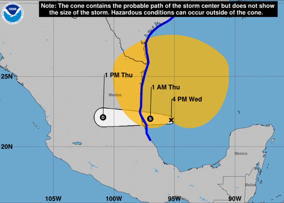
Alerts: There’s a Tropical Storm Warning for the Texas coast from San Luis Pass down to the mouth of the Rio Grande River and for the northeastern Mexican coast from that mouth of the Rio Grande to Tecolutla, a resort town on the Gulf of Mexico.
Hazards: Alberto is forecast to dump up to 20 inches of rain “across the higher terrain of the Mexican states of Coahuila, Nuevo Leon, and Tamaulipas” and 5 to 10 inches in Northeast Mexico and South Texas, according to the National Hurricane Center’s 2 p.m. Wednesday advisory. Mudslides are possible in parts of Northeast Mexico. Parts of Texas are looking at a storm surge up to 4 feet.
“The deepest water will occur along the immediate coast near and to the north of the landfall location, where the surge will be accompanied by large and dangerous waves,” the hurricane center forecasts.
Tornadoes are possible in Texas. Swells “are likely to cause life-threatening surf and rip current conditions.”
Advisories: There will be an intermediate advisory at 7 p.m. and a complete advisory at 10 p.m., Eastern time.
The Atlantic Disturbance
“An area of showers and thunderstorms located several hundred miles east of the Bahamas is associated with a surface trough of low pressure,” the hurricane center’s 5 p.m. Wednesday update said. “Environmental conditions are marginally conducive for some gradual development of this system during the next few days while it moves westward or west-northwestward.
“The system is forecast to approach the coast of the southeastern United States by Friday.”
Formation chance in the next two days: 20%
Formation chance in the next week: 20%

