Humidity on the rise tomorrow, rain chance Sunday
The Latest Northeast Wisconsin Forecast from Storm Team 5…
Its been the definition of a perfect summer day here this afternoon with seasonal temperatures, comfy dew points, light winds and of course plenty of sunshine. For the rest of today, I’m expecting sunshine to give way to clear skies and low temperatures to fall back into the mid to upper 50s.
A few morning clouds might graze overhead during the morning along the tail end of a weak warm front, but into the afternoon we should return to sunny skies. However, this front, as well as being on the western side of an area of high pressure will pick up the winds to near 15mph out of the south to help to warm us up and bring in very oppressive dew points.
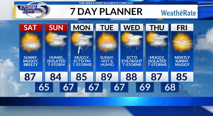
It will start off fairly comfy on Saturday, but the muggy meter will increase in the afternoon. Highs tomorrow will sit in the mid 80s, cooler temperatures lakeside. Should also note, you might notice a faint haze in the sky from a plume of wildfire smoke, but does not look like it will cause many issues.
Saturday night will feature increasing clouds as a weak system approaches from the south. Expect partly to mostly cloudy skies for Sunday, with a chance for an afternoon or evening isolated shower or storm. Isolated means not everyone is guaranteed rain, but if it does, it looks quiet brief. Should be a fairly nice day for the final day of EAA in Oshkosh. Highs will sit in the mid 80s but it will be quite muggy.
Monday features another chance of pop up thunderstorms before a dry, muggy and hot Tuesday. More rain and thunderstorm chances possible Wednesday and Thursday, but no day this week will be complete washouts. Highs still stay in the mid to upper 80s with tropical like dew points, so plan accordingly.
Copyright 2024 Nexstar Media, Inc. All rights reserved. This material may not be published, broadcast, rewritten, or redistributed.

