
Hurricane Beryl re-intensifies to a Category 4 as it closes in on the Windward Islands
After briefly dipping into Category 3 strength, Hurricane Beryl re-intensified into a Category 4 storm as it approached the Windward Islands Monday morning.
The historic early-season whopper of a storm is expected to bring up to nine feet of storm surge, double-digit rain and sustained winds topping 130 mph through Monday, prompting hurricane watches and warnings for the islands as well as government shutdowns in Barbados and St. Lucia.
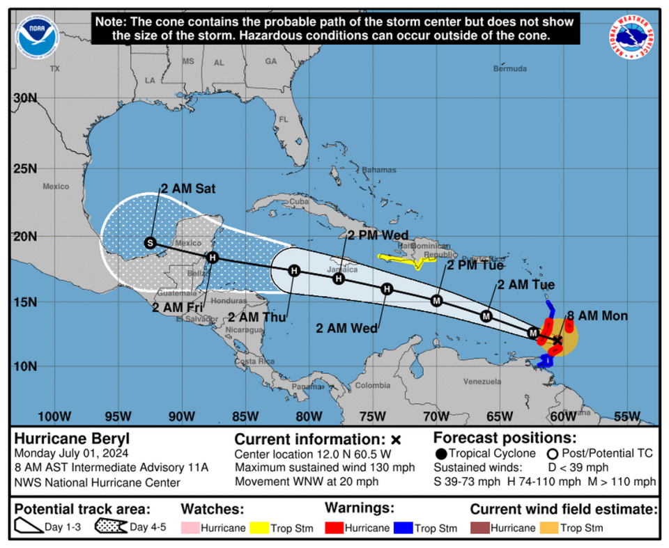
As of the 8 a.m. update from the National Hurricane Center, Beryl was about 70 miles east of Grenada, heading west-northwest at 20 mph with sustained winds near 130 mph.
Early Monday, hurricane hunter planes swooped over the roiling storm and found it in the final stages of an eyewall replacement cycle, where a bigger, stronger eye emerges and dwarfs the previous one. Storms typically weaken a bit during the replacement cycle but emerge stronger on the other side, as Beryl did.
Overnight, during the replacement cycle, the slightly weakened Beryl grew its wind field substantially, increasing its reach for storm surge and wind effects in the Windward Islands. As of 8 a.m., tropical-storm-force winds extended out 35 miles from the center, and hurricane-force winds extended out up to 125 miles.
In the 5 a.m. discussion, forecasters noted that Beryl was about to encounter an area of low wind shear, which, combined with the higher-than-usual sea surface temperatures nearby, aided its explosion of growth back to a Category 4 storm.
Over the weekend, Beryl surpassed expectations and rapidly intensified into the first major hurricane of the season in the abnormally hot Atlantic. Beryl is now the earliest Category 4 storm to form in the Atlantic, beating out a record from Hurricane Dennis set on July 8, 2005, a notably intense year for storms.
Grenada Prime Minister Dickon Mitchell said they have received various reports of rainfall but so far no major reports of damage as of 7 a.m. as Beryl barreled across the Caribbean.
Illustration of how much Beryl grew after its eyewall replacement cycle. Double the size (based on its radius of maximum winds) vs last night https://t.co/EWFj5Yru2Y
— Michael Lowry (@MichaelRLowry) July 1, 2024
“I’m thankful for that. It means so far our prayers have been answered but the next eight hours are absolutely critical,” he said. “We expect significant rainfall, we expect significant wind gusts and we expect significant storm surges.”
Mitchell emphasized that the state of emergency, which went into effect Sunday evening, remains in place.
Given its speed, Mitchell said they expect the storm to very well be covering all of Grenada, Carriacou and Petite Martinique.
In Tobago, gusty winds and fallen trees were already reported from Beryl Monday morning. The island is under a hurricane warning while Trinidad is under a tropical storm warning.
As Beryl regained strength and entered the eastern Caribbean, Jamaica advised all fishermen to stay out of the ocean.
What’s next?
Once it clears the Windward Islands, Beryl’s future is a little less clear. The latest hurricane center forecast track keeps the storm on a straight shot to the Yucatan, where it could make landfall near Belize as a Category 2 hurricane Friday morning.
On the way, it could pass dangerously close to Jamaica on Wednesday, enough to lash the island with high winds and storm surge.
On the other side of the Yucatan, short-lived Tropical Storm Chris fizzled out early Monday, dumping some rain over Mexico and crossing another name off the list.
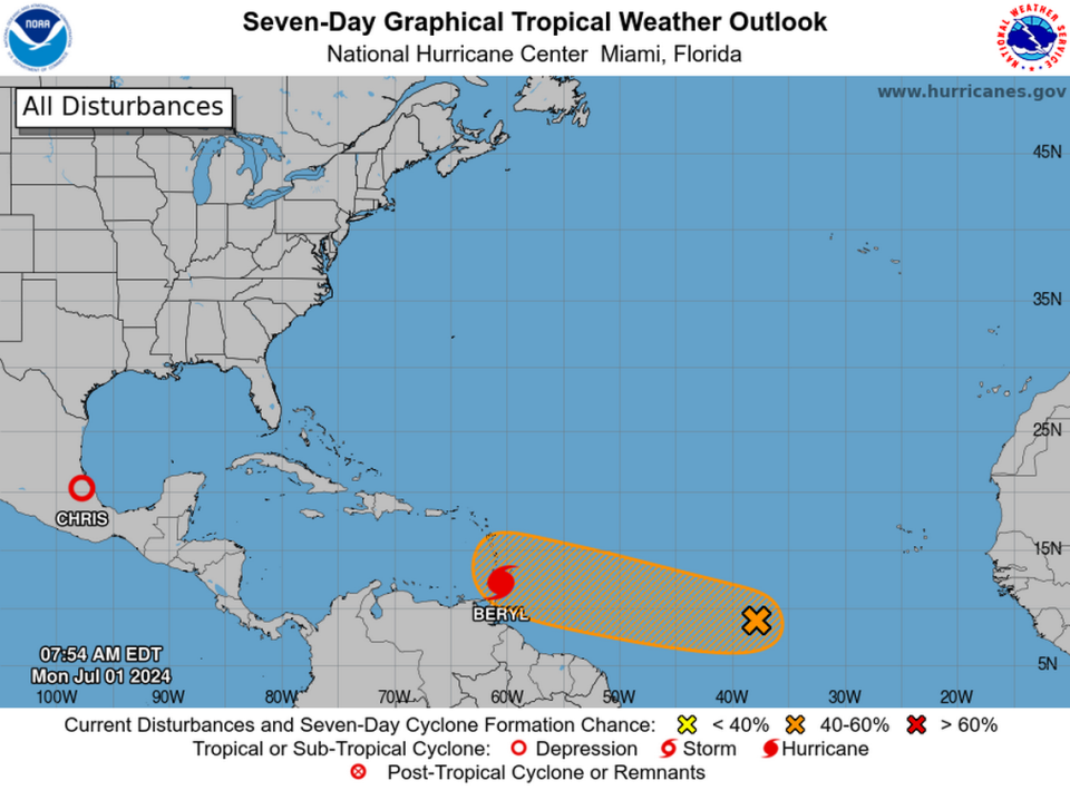
The next contender could be right behind Beryl, a disturbance the hurricane center has tagged with a 60% chance of strengthening into a tropical depression or storm within the next seven days, and a 30% chance of forming in the next two, as of the 8 a.m. update.
Those figures are a slight downgrade from earlier in the morning, a sign that the cooler water left in Beryl’s wake and increased wind shear nearby could slow down the development of anything behind it.
“Environmental conditions appear marginally conducive for additional development of this system, and a tropical depression could form by the middle part of this week while it moves generally westward at 15 to 20 mph across the central and western tropical Atlantic,” forecasters wrote.
The next name on the list is Debby.

