Hurricane Beryl makes landfall with 150-mph winds. Where will it go next?
Hurricane Beryl made landfall on Carriacou Island with 150-mph winds, just short of a Category 5 storm, according to a special advisory at 11:10 a.m. from the National Hurricane Center.
Winds strengthened all morning and hit 150 mph as the storm passed over the Windward Islands, bringing life-threatening winds and storm surge.
The "extremely dangerous" hurricane has now entered the southeastern Caribbean.
Beryl's strength keeps fluctuating. Sustained winds have dropped as low as 120 mph and as high as 150 mph Monday morning.
Beryl is a major hurricane, which is any hurricane that's Category 3 or higher. A Category 3 storm is one that has sustained winds of at least 111 mph. A Category 4 storm has winds of 130 to 156 mph.
"Potentially catastrophic wind damage is expected where the core of Beryl moves through portions of the Windward Islands," the National Hurricane Center said.
Where is Carriacou Island?
Carriacou Island is located less than 30 miles northeast of Grenada, about 50 miles southwest of St. Vincent and the Grenadines. The island is about 1,500 miles southeast of Miami.
Hurricane Beryl sets record as earliest Category 4 storm on record
#Hurricane #Beryl is now a Category 4 hurricane with max winds of 130 mph - the earliest calendar year Atlantic Category 4 hurricane on record. Old Atlantic record for earliest Category 4 hurricane was Hurricane Dennis on July 8, 2005 at 0UTC. pic.twitter.com/JAG4QGLgBh
— Philip Klotzbach (@philklotzbach) June 30, 2024
Beryl wasted no time in growing into a powerful hurricane over the weekend.
The system making its way quickly across the Atlantic became a tropical depression Friday afternoon, a tropical storm by late Friday night and a hurricane about 24 hours later on Saturday.
By Sunday morning, Beryl had strengthened into a major Category 4 hurricane, with winds of 130 mph.
"Beryl will be one of the strongest hurricanes to ever pass through the Grenadines," The Weather Channel meteorologist Jim Cantore tweeted.
It's the earliest Category 4 storm in the Atlantic basin on record, according to Philip Klotzbach, meteorologist at Colorado State University specializing in Atlantic basin seasonal hurricane forecasts. The prior record was Hurricane Dennis on July 8, 2005.
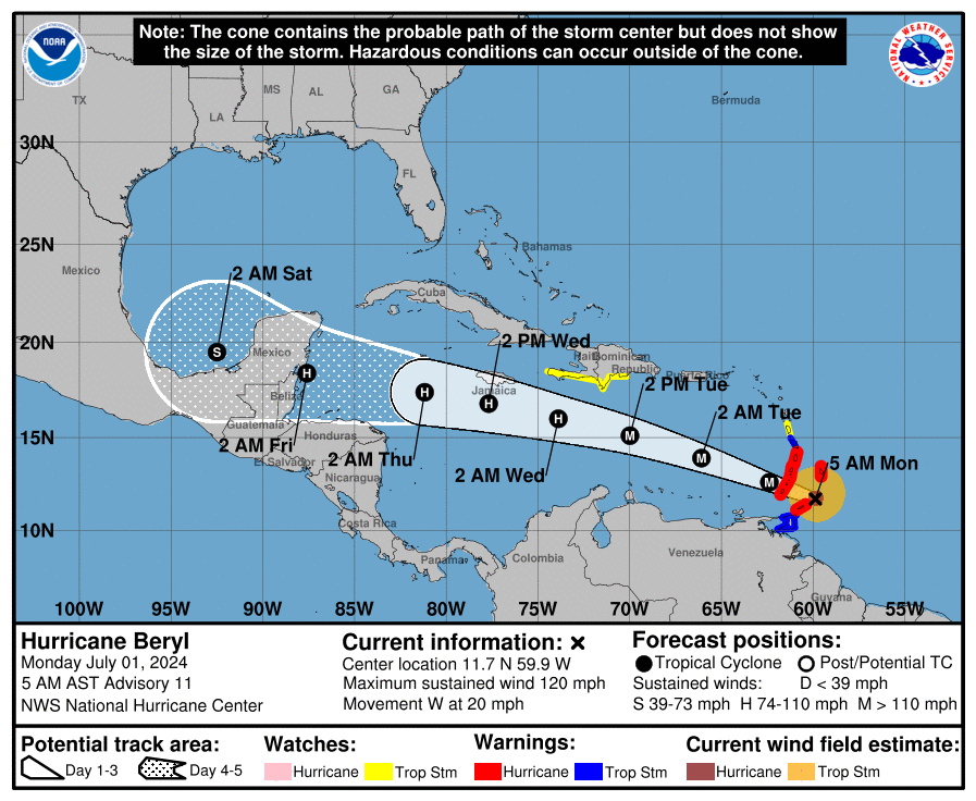
Spaghetti models: Where will Hurricane Beryl go?
Special note about spaghetti models: Illustrations include an array of forecast tools and models, and not all are created equal. The hurricane center uses only the top four or five highest performing models to help make its forecasts.
Will Hurricane Beryl impact Florida?
AccuWeather meteorologists currently don't expect Beryl to impact Florida and the U.S., but warn residents to not let down their guard.
"Direct impacts to the United States look unlikely; however, it is very important to note that if the high pressure across the Southeast weakens, that can allow the storm to move farther north and potentially directly impact the Gulf Coast," AccuWeather Lead Hurricane Forecaster Alex DaSilva said.
"At this point, the most likely scenario is for the storm to move westward into Mexico. However, it is very important to note that if the high pressure across the Southeast weakens, that can allow the storm to move farther north and potentially directly impact the Gulf Coast," DaSilva said.
Watches, warnings issued across Florida
Hurricane Beryl: What you need to know
Location: About 30 miles west-northwest of Carriacou Island; 65 miles northwest of Grenada
Maximum sustained winds: 150 mph
Movement: West-northwest at 20 mph
Pressure: 946 mb
Next advisory: 5 p.m.
Watches and warnings issued for Hurricane Beryl
For an explanation of what the watches and warnings mean, scroll to the bottom of this story.
Hurricane warning: A hurricane warning is in effect for:
St. Vincent and the Grenadine Islands
Grenada
Hurricane watch: A hurricane watch is in effect for:
Jamaica
Tropical Storm Warning: A tropical storm warning is in effect for the following:
Martinique
St. Lucia
Tropical storm watch: A tropical storm watch is in effect for the following:
South coast of Dominican Republic from Punta Palenque westward to the border with Haiti
South coast of Haiti from the border with the Dominican Republic to Anse d'Hainault
Hurricane Beryl 'powerful' Category 4 hurricane with 150-mph winds
At 2 p.m., the eye of Hurricane Beryl was located near latitude 12.8 North, longitude 62.3 West.
Beryl is moving toward the west-northwest near 20 mph. The center of Beryl will move away from the southern Windward Islands tonight and pass quickly westward to west-northwestward during the next few days.
On the forecast track, the center of Beryl will move across the southeastern and central Caribbean Sea tonight through Wednesday.
Maximum sustained winds are near 150 mph, with higher gusts. Beryl is a Category 4 hurricane on the Saffir-Simpson Hurricane Wind Scale.
Fluctuations in strength are likely during the next day or so, but Beryl is expected to remain an extremely dangerous major hurricane as its moves over the eastern Caribbean. Some weakening is expected in the central Caribbean by midweek, though Beryl is forecast to remain a hurricane.
Hurricane-force winds extend outward up to 40 miles from the center and tropical-storm-force winds extend outward up to 125 miles.
Beryl has been growing larger Monday.
Hurricane #Beryl eyewall replacement cycle via microwave satellite imagery. The area of stronger winds has expanded so hazards related to #HurricaneBeryl will impact a larger area. https://t.co/socfSWOoyL pic.twitter.com/fkzDkZkYUW
— UW-Madison CIMSS (@UWCIMSS) July 1, 2024
How strong is Hurricane Beryl and where is it going?
Key messages from the National Hurricane Center: What you need to know about Hurricane Beryl
The eyewall of Beryl is moving through the southern Windward Islands. This is an extremely dangerous and life-threatening situation. Take action now to protect your life! Residents in Grenada, the Grenadine Islands, and Carriacou Island should not leave their shelter as destructive winds and life-threatening storm surge are expected during the next few hours. Shelter in place through the passage of these life-threatening conditions and do not venture out in the eye of the storm.
Heavy rainfall and localized flash flooding are expected across the Windward Islands through this afternoon.
Beryl is expected to remain a powerful hurricane as it moves across the Caribbean Sea later this week. A Hurricane Watch has been issued for Jamaica. Interests in the Cayman Islands, Belize, the Yucatan Peninsula, and the remainder of the northwestern Caribbean should monitor its progress. Additional watches and warnings will likely be required during the next day or two.
Current forecast: How strong is Hurricane Beryl expected to get?
12 hours: 145 mph
24 hours: 145 mph
36 hours: 125 mph
48 hours: 110 mph
60 hours: 105 mph
72 hours: 90 mph
96 hours: 75 mph inland
120 hours: 65 mph over water
What impact could Hurricane Beryl have and what areas could be affected?
WIND: Hurricane conditions are occurring in the hurricane warning area. Potentially catastrophic wind damage is expected where the core of Beryl is moving through portions of the southern Windward Islands, including Carriacou Island, Grenada, and the Grenadine Islands.
Wind speeds atop and on the windward sides of hills and mountains are often up to 30 percent stronger than the near-surface winds indicated in this advisory, and in some elevated locations could be even greater.
Hurricane conditions are possible in Jamaica by Wednesday. Tropical storm conditions are occurring or imminent in the tropical storm warning area. Tropical storm conditions are possible within the watch area by Tuesday afternoon for parts of the southern coast of Hispaniola.
STORM SURGE: A life-threatening storm surge will raise water levels by as much as 6 to 9 feet above normal tide levels in areas of onshore winds near where the eye makes landfall in the hurricane warning area. Near the coast, the surge will be accompanied by large and destructive waves.
RAINFALL: Hurricane Beryl is expected to produce rainfall totals of 3 to 6 inches across Barbados and the Windward Islands through this afternoon. Localized maxima of 10 inches are possible, especially in the Grenadines, Tobago, and Grenada. This rainfall may cause flash flooding in vulnerable areas.
SURF: Large swells generated by Beryl are expected across the Windward and southern Leeward Islands during the next couple of days. Swells are also expected to reach the southern coasts of Puerto Rico and Hispaniola in the next day or so. These swells are expected to cause life-threatening surf and rip current conditions.
Interactive map: What tropical storms, hurricanes have impacted your area in the past?
What do the watches and warnings from NHC mean?
What is storm surge? Graphics explain the deadly weather event
Hurricane warning: A hurricane warning means that hurricane conditions are expected somewhere within the warning area. A warning is typically issued 36 hours before the anticipated first occurrence of tropical-storm-force winds, conditions that make outside preparations difficult or dangerous. Preparations to protect life and property should be rushed to completion.
Hurricane watch: A hurricane watch means that hurricane conditions are possible within the watch area. A watch is typically issued 48 hours before the anticipated first occurrence of tropical-storm-force winds, conditions that make outside preparations difficult or dangerous.
Tropical storm warning: A tropical storm warning means that tropical storm conditions are expected somewhere within the warning area within 36 hours.
Tropical storm watch: An announcement that sustained winds of 39 to 73 mph are possible within the specified area within 48 hours in association with a tropical, subtropical, or post-tropical cyclone.
Storm surge warning: A storm surge warning means there is a danger of life-threatening inundation, from rising water moving inland from the coastline, in the indicated locations. This is a life-threatening situation. Persons located within these areas should take all necessary actions to protect life and property from rising water and the potential for other dangerous conditions. Follow evacuation and other instructions from local officials.
Storm surge watch: A storm surge watch means there is a possibility of life-threatening inundation, from rising water moving inland from the coastline, in the indicated locations during the next 48 hours.
This article originally appeared on Treasure Coast Newspapers: Hurricane Beryl storm track. Where is storm, spaghetti models

