
Forecasters track third disturbance. It may follow similar path to incoming Caribbean system
While two systems are still moving steadily through the Atlantic, forecasters are now tracking a third early Friday morning.
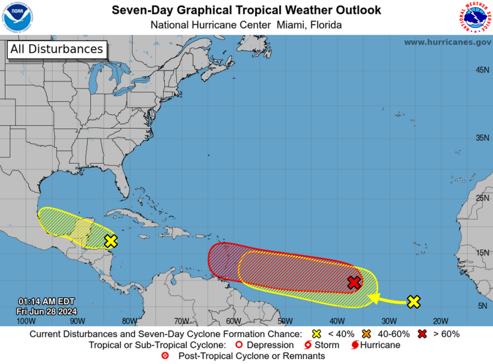
The newest disturbance has a low chance of forming; however, it could follow a similar path to a system on the cusp of becoming a named storm in the Caribbean, the National Hurricane Center said.
Tropical Storm Beryl could form soon
The system to watch is a tropical wave still in the deep Atlantic that the center has rapidly increased its prediction for when it might strengthen.
As of early Friday morning, it had a 90% chance of forming into a tropical depression or storm in the next seven days, up from 70% the morning before. The center also increased its shot of strengthening in the next two days to 80%.
“Environmental conditions appear conducive for additional development, and a tropical depression or tropical storm is likely to form over the next day or two,” forecasters wrote.
The increasing confidence is likely due to growing agreement within the array of global weather models forecasters use to help predict when and where storms will form.
Although it’s too early to know the eventual destination of this system, which would be Tropical Storm Beryl, forecasters warned that residents of the Lesser Antilles should prepare for a potential storm this weekend.
“Keep an eye on it,” tweeted Jim Cantore of the Weather Channel.
Wednesday evening, the hurricane center noted that conditions were unusually good for storm formation in the area.
While most of the main development region of the Atlantic is swathed in storm-dampening Saharan dust this week, the tropical wave in question is swirling in a pocket that doesn’t have much of that hot, dry dust.

It’s also floating in some abnormally warm water, as sea surface temperatures in the area are running at September-level temperatures in June. Hot water is fuel for storms, which is why NOAA predicted this storm season could potentially be one of the most active on record.
But while conditions appear to be ripe for this wave to strengthen into Tropical Storm Beryl over the weekend, and potentially approach the Windward Islands on Sunday or Monday, where it goes from there is up in the air.
“Way too early to know the ultimate destination of this system; it all depends on how the upper air pattern evolves in 7-10 days,” wrote James Spann, a meteorologist with Alabama’s ABC 33 40, on Twitter. “Model spread is anywhere from Central America to the Bahamas; we will have much better clarity early next week.”
Forecasters track two other systems
In the center’s 2 a.m. advisory, forecasters began tracking a new tropical wave a few hundred miles south-southwest of the Cabo Verde Islands.
The system is predicted to develop slowly early next week while moving west across the central and western tropical Atlantic. Where it will go is unknown, but much of its forecast path overlaps with the system expected to become a tropical depression or storm.
It has no chance of forming in the next two days, and a low 20% chance in the next seven.
Another system, a broad area of low pressure, is being tracked over the western Caribbean Sea. Forecasters say there could be some development over the northwestern Caribbean or southwestern Gulf of Mexico in the next few days.
It has a 20% chance of forming in the next two days, and 30% in the next seven.

