
Hurricane center monitoring system that could form in the Caribbean next week
The first Atlantic-born storm of the season could form in the Caribbean next week, forecasters said.
The National Hurricane Center began tracking the system officially on Wednesday morning, and upgraded its chances of formation within the next week to 40% by the afternoon, and a 10% chance of strengthening into a tropical depression or storm in the next two days.
The hurricane center noted the system was moving west at a fast clip — 25 mph — and could slowly strengthen as it crosses the Caribbean Sea or Southwestern Gulf of Mexico over the weekend.
It’s still too far out for the center to issue predictions on what could happen next, but global hurricane models appear to support development into a tropical storm or even a hurricane early next week.
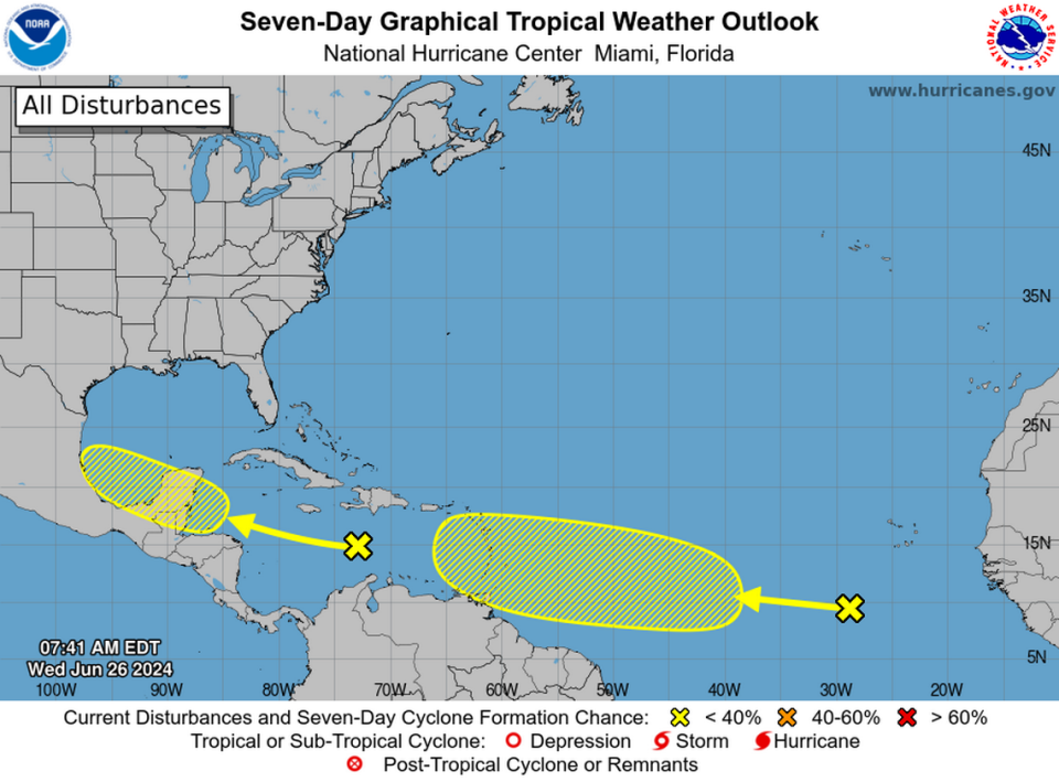
However, experts warn, the models aren’t in strong agreement about where it could go or when, precisely, it could form. Before a storm with a strongly defined center actually forms, hurricane models struggle to predict their movements accurately.
“While models have waffled some on which feature may be the one to develop – with some runs indicating development of another wave rolling off Africa later in the week – they do agree that the environment east of the easternmost Caribbean islands will be ripe for formation this weekend into early next week,” wrote Michael Lowry, hurricane specialist for Local 10 news, in a blog post.
“Interests in the Lesser Antilles and eastern Caribbean will want to monitor the progress of this system closely over the coming days,” he said.
Earlier this week, forecasters noted a large plume of Saharan dust was making its way across the Atlantic, a development that usually quells storm formation and strengthening (while worsening allergies).
READ MORE: Saharan dust is coming to Florida. Here’s how it can affect hurricanes and your health
However, it appears that both this tropical wave and the other one, near Mexico, are moving in pockets of air with very little of that dry, hot dust.
Instead, the tropical wave in the east Atlantic is moving in a current of warmer-than-average water, which is a known fuel for storms.
“60% of the Atlantic Main Development Region is currently warmer in late June than it typically is in August, near the peak of hurricane season,” noted Ben Noll, a meteorologist with New Zealand’s National Institute of Water & Atmospheric Research, on Twitter on Wednesday.
60% of the Atlantic Main Development Region is currently warmer in late June than it typically is in August, near the peak of hurricane season
This very favorable oceanic environment will be tested this weekend and next week as tropical waves begin to traverse the basin... pic.twitter.com/ahNB6J6QPv— Ben Noll (@BenNollWeather) June 26, 2024
Earlier this year, NOAA flagged increasingly hot sea surface temperatures as the main reason it issues a seasonal forecast calling for more storms than ever before: 17 to 25 named storms, 8 to 13 hurricanes and 4 to 7 major hurricanes.
The system is also surrounded by lower-than-average storm-crunching wind shear, said meteorologist Levi Cowan of Tropical Tidbits.
“These favorable conditions could lead to tropical storm development, which both the GFS and ECMWF models have been increasing chances for,” he posted on Twitter.
For now, one factor working against any potential storm development appears to be the location of the tropical wave.
“The wave is cruising along around or just south of 10 degrees latitude, a region in which only a handful of June and July storms have generally developed,” meteorologist Matt Lanza of the Eyewall noted in a blog post. “These storms ended up with mixed outcomes, including a couple hurricanes, a couple dissipating in the Caribbean, and a couple making it toward the Gulf. No strong signal exists either way.”
So far this year, we’ve seen Tropical Storm Alberto briefly spin up near Mexico’s northeast coast, drenching Texas and Mexico with plenty of rain.
If this tropical wave does strengthen, the next storm name on the list is Beryl.

