Tropical depression track shifts west. Heavy rain remains a threat for South Florida
A westward track shift overnight could keep the Florida Keys, and South Florida, away from the higher winds of Tropical Depression 4 this weekend as it crosses Cuba and heads into the eastern Gulf of Mexico.
The storm’s biggest threat appears to be rain, for now, and South Florida could see several inches on Saturday and Sunday, enough to cause street flooding in low-lying spots. The Florida Keys remain under a tropical storm watch, and Miami-Dade and Broward are under a flood watch.
The National Hurricane Center said the warm waters of the Gulf could be enough to help the depression strengthen into Tropical Storm Debby by Saturday night, as it travels along Florida’s west coast.
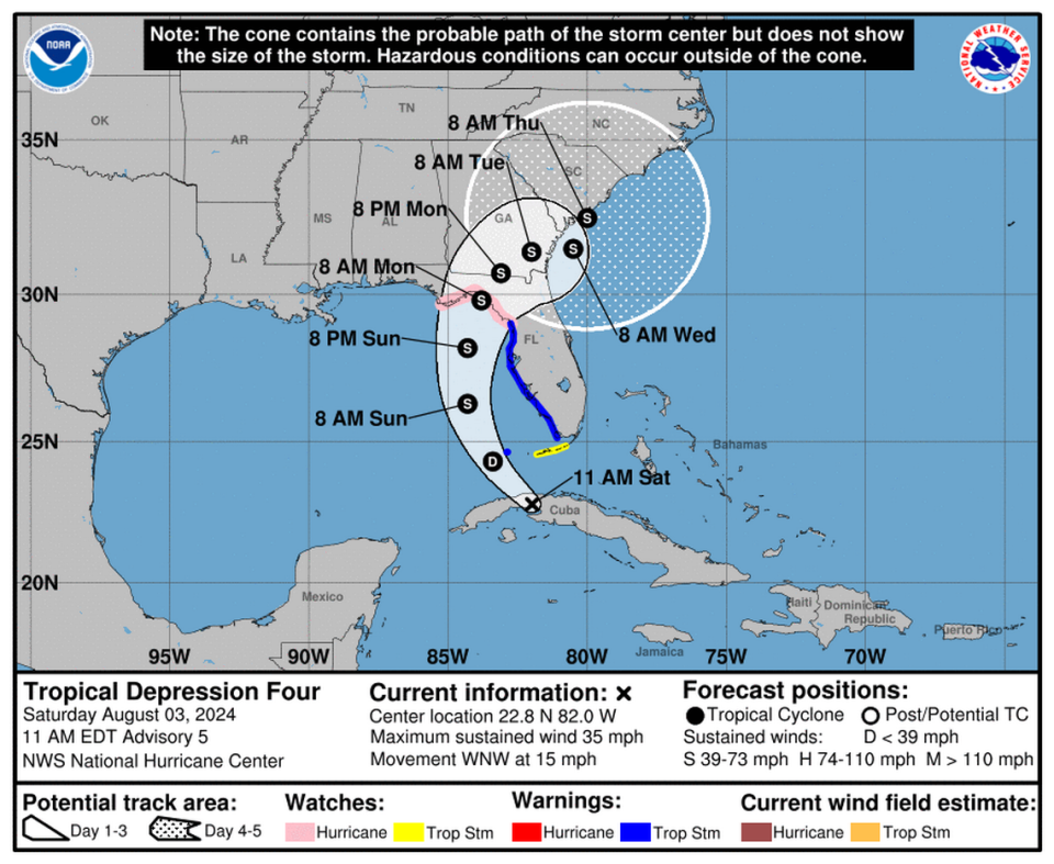
It could keep strengthening ahead of a landfall Monday in Florida’s Big Bend region, which is under a hurricane watch.
“Due to the lack of internal organization, the initial intensification is likely to be slow. However, a faster rate of development is likely once the system gets better organized, and the cyclone is likely to be near or at hurricane strength when it reaches to the northern Gulf coast,” forecasters wrote in the 11 a.m. discussion Saturday.
While that region could see high-end tropical storm or hurricane winds, officials warned that rain was the thing to watch for this depression. The Miami office of the National Weather Service said Florida could feel 2 to 5 inches of rain across much of the state with totals up to 8 inches in some spots.
Storm surge is also a concern on the west coast. Tampa Bay could see 2 to 4 feet, and the area near potential landfall could see 3 to 5 feet, which prompted a storm surge watch between the Aucilla River to Indian Pass.
As of 11 a.m. Saturday, the depression was about 125 miles south of Key West, headed west-northwest at 15 mph with sustained winds of 35 mph, a slight uptick from earlier in the day.

