
Tropical Storm Beryl forms, expected become hurricane as it approaches Caribbean
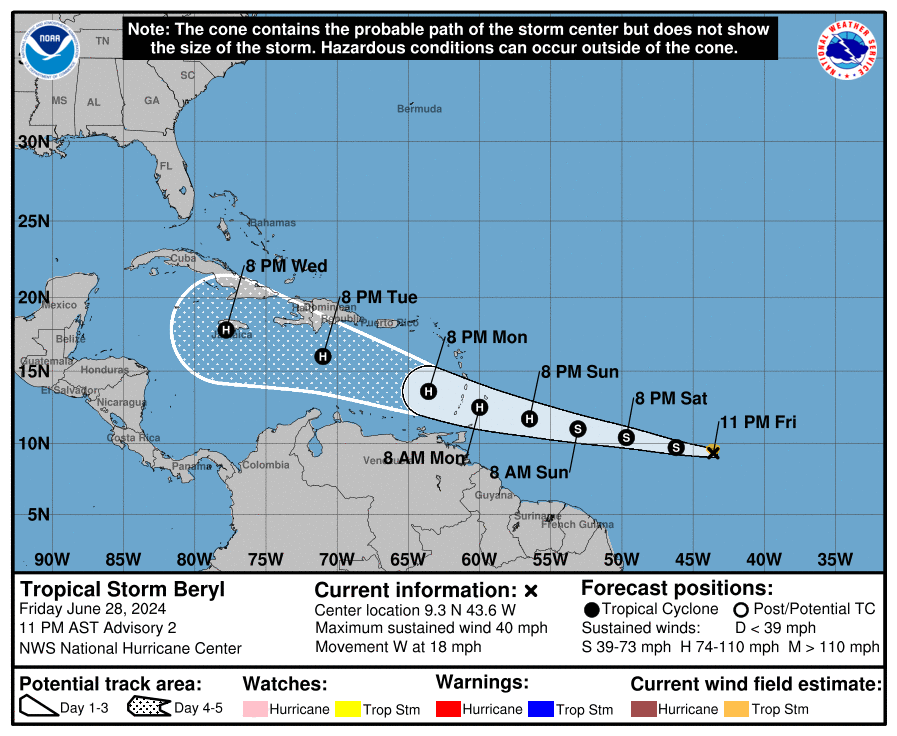
Tropical Storm Beryl formed late Friday with maximum sustained winds of 40 mph, one of only a few storms in history that have formed over the central or eastern tropical Atlantic this early in the year, according to the latest advisory from the National Hurricane Center
Beryl is the second named storm of the 2024 Atlantic hurricane season.
➤ Spaghetti models for Tropical Storm Beryl
According to the NHC's 11 p.m. update, the center of Tropical Storm Beryl was located 1110 miles east-southeast of Barbados and moving west at 18 mph. A relatively quick westward to west-northwestward motion is expected during the next few days.
Tropical-storm-force winds extend outward up to 45 miles from the center.
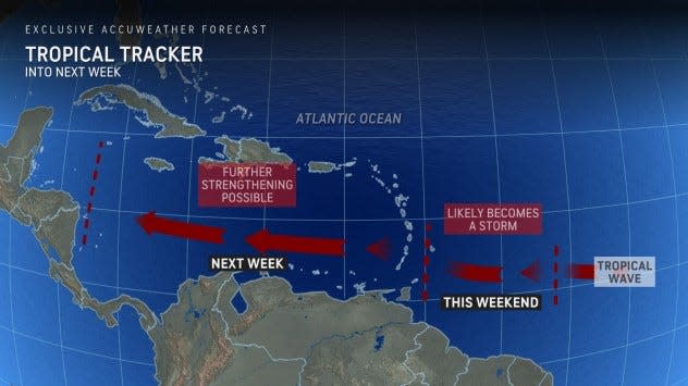
On the forecast track, the system is expected to move across the Windward Islands late Sunday night and Monday.
Beryl is expected to strengthen and be a hurricane when it reaches the Windward Islands, bringing a risk of heavy rainfall, hurricane-force winds, and dangerous storm surge and waves.
Swells generated by the system are likely to cause life-threatening surf and rip current conditions.
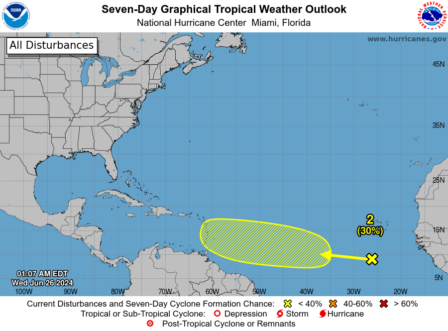
Two other tropical waves in the Atlantic basin, including Invest 94L in the Caribbean, currently have medium chances for development, according to the Hurricane Center.
➤ Spaghetti models for Invest 94L
Why isn't Saharan dust preventing storms from developing?
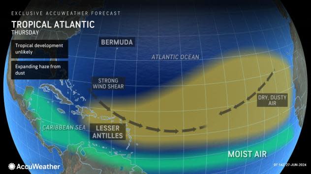
Saharan dust, which is moving west over the Atlantic, makes it difficult for storms to develop as it steals the moist air storms need to develop.
But Tropical Storm Beryl is in the "sweet spot" as it travels west across the Atlantic.
"This feature is tracking south of a zone of dry air, dust and stiff disruptive breezes called wind shear," AccuWeather Chief On-Air Meteorologist Bernie Rayno said.
"Should the system stay in the moist zone and away from large land areas, it has the potential to ramp up quickly — perhaps to a major hurricane (sustained winds of 111-129 mph)," AccuWeather said.
Historically high ocean temperatures aren't helping.
"This exceptional warmth may also trigger the rapid strengthening of tropical systems as the season progresses. When rapid strengthening occurs near land, it may cause dangers to lives and property to increase exponentially with little notice," AccuWeather said.
Recent tropical activity unusual for this time of year
"Storms typically do not strengthen regularly over the main hurricane development zone until mid-August or later," according to AccuWeather.
"The period from late June through much of July is typically quiet with only one or two named systems by mid- to late July."
Here's the latest update from the NHC as of 2 p.m. June 28:
Where is Tropical Storm Beryl? Will it become a hurricane?
Since becoming a depression earlier this afternoon, deep convection has continued to burst with infrared satellite imagery depicting cold cloud tops down to -80C. The center of circulation remains on the eastern side of the deep convection, but the system is gradually becoming better organized with banding features and better vertical alignment. Intensity estimates have increased this cycle with subjective Dvorak estimates of T2.0/T2.5 from SAB and TAFB, respectively. Objective Dvorak estimates from UW-CIMSS are around 39-41 mph as well. Using a blend of these estimates, the initial intensity for this advisory is set to 40 mph, and the depression has strengthened into Tropical Storm Beryl. Tropical Storm Beryl is one of only a few storms in history that have formed over the central or eastern tropical Atlantic this early in the year, according to the NHC.
Tropical Storm Beryl is moving westward at 18 mph, steered by a strong subtropical ridge to the north. This should keep Beryl moving swiftly westward to west-northwestward during the next few days, with the model guidance remains tightly clustered as the system moves towards the Windward Islands. There is a little more spread in the model guidance beyond day 3, when the system nears a weakness in the subtropical ridge. The NHC track forecast lies near the consensus aids near the middle of the guidance envelope and is very similar to the previous forecast track. Based on this forecast, the system is expected to move across the Windward Islands Sunday night and Monday and track across the eastern and central Caribbean Sea through the middle of next week.
Atmospheric and oceanic conditions, atypical for this time of year, are fairly favorable for strengthening the next few days with warm sea surface temperatures, plenty of moisture, and low vertical wind shear. Thus, the NHC intensity forecast calls for steady strengthening and shows the system becoming a hurricane before it reaches the Windward Islands. The NHC intensity forecast is very similar to the previous advisory. It should be noted that some of the model guidance is still quite aggressive and a fair amount are even higher than the official forecast. Some hurricane regional models and consensus aids show the system becoming a major hurricane prior to reaching the Windward Islands.
Spaghetti models for Tropical Storm Beryl
Can't see the map? Open in a new browser.
Special note about spaghetti models: Spaghetti model illustrations include an array of forecast tools and models, and not all are created equal. The hurricane center uses only the top four or five highest performing models to help make its forecasts.
Tropical Storm or Hurricane Beryl? Could Florida, US feel an impact?
It’s becoming likely that we will have a Hurricane named #Beryl plowing through the Windward Islands Mon am through Tues am. Data shows it reaching Cat 1 status with winds 74-95 mph. All interests in the Windward Islands should be preparing for a hurricane. Upgrade likely today pic.twitter.com/JxbkhDK9Hi
— Hurricane Tracker App (@hurrtrackerapp) June 28, 2024
"Depending on steering breezes, the system may push westward across Central America later next week or turn northwestward and reach the western Gulf of Mexico next weekend, where it would become a concern for the United States," according to AccuWeather.
Forecasters recommended residents in the Caribbean, Central America and the Gulf Coast of the U.S. monitor the system closely.
Where is Invest 94L? Will it become tropical storm?
A broad area of low pressure over the northwestern Caribbean Sea continues to produce widespread but disorganized shower and thunderstorm activity. Development of this low is not anticipated before it moves inland over the Yucatan Peninsula on Saturday. The system is then forecast to move west-northwestward, emerging over the Bay of Campeche Saturday night or early Sunday, where conditions appear generally conducive for further development. A tropical depression could form before the system moves inland again early next week over Mexico.
Regardless of development, heavy rainfall associated with the area of low pressure will affect portions of Central America and Mexico through early next week.
Formation chance through 48 hours: medium, 40 percent.
Formation chance through 7 days: medium, 40 percent.
Spaghetti models for Invest 94L
Can't see the map? Open in a new browser.
Special note about spaghetti models: Spaghetti model illustrations include an array of forecast tools and models, and not all are created equal. The hurricane center uses only the top four or five highest performing models to help make its forecasts.
What else is out there and how likely is it to strengthen?
Eastern tropical wave: A tropical wave located several hundred miles south-southwest of the Cabo Verde Islands is producing an area of disorganized showers and thunderstorms.
Environmental conditions appear generally conducive for additional development of this system, and a tropical depression could form by the middle of next week while it moves generally westward at 15 to 20 mph across the eastern and central tropical Atlantic.
Formation chance through 48 hours: low, near 0 percent.
Formation chance through 7 days: medium, 40 percent.
Who is likely to be impacted?
Tropical Storm Beryl: Residents in the central and western Caribbean should monitor the progress of this system. Users are reminded that there is large uncertainty at days 4 and 5 and to not focus on the specific details of the track or intensity forecast.
Residents in the Windward Islands could experience heavy rainfall, hurricane-force winds, and dangerous storm surge and waves. Swells generated by the system are likely to cause life-threatening surf and rip current conditions.
Invest 94L: Regardless of development, heavy rainfall associated with the area of low pressure will affect portions of Central America and Mexico through early next week.
Forecasters urge all residents to continue monitoring the tropics and to always be prepared. That advice is particularly important for what is expected to be a very active hurricane season.
Weather watches and warnings issued in Florida
When is the Atlantic hurricane season?
The Atlantic hurricane season runs from June 1 through Nov. 30.
When is the peak of hurricane season?
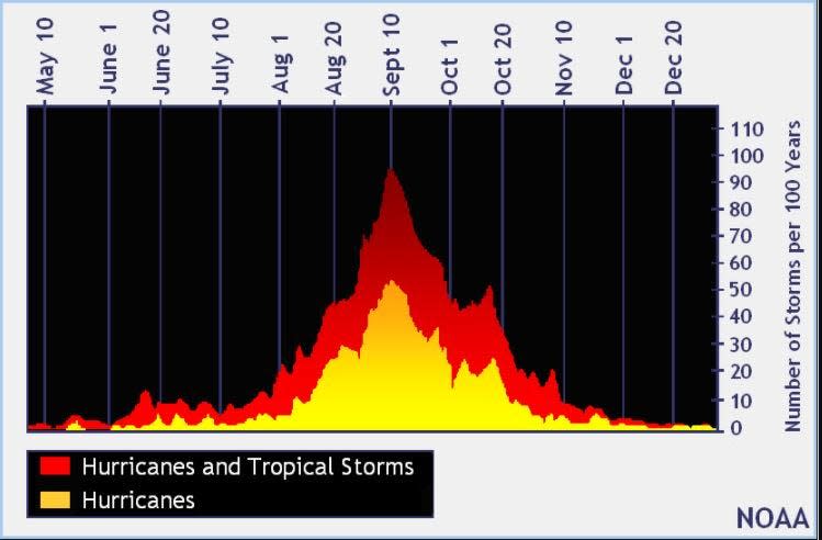
The peak of the season is Sept. 10, with the most activity happening between mid-August and mid-October, according to the Hurricane Center.
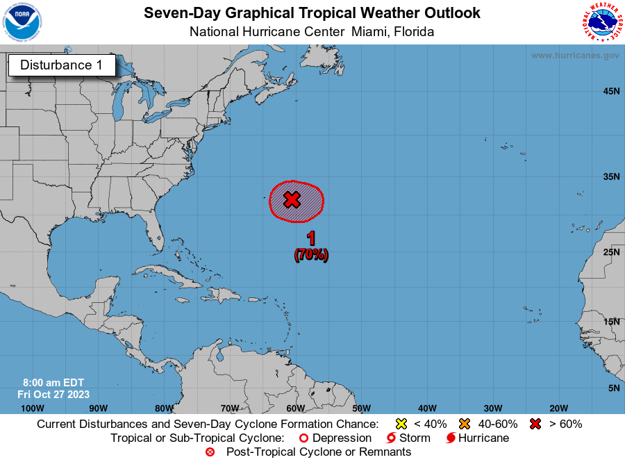
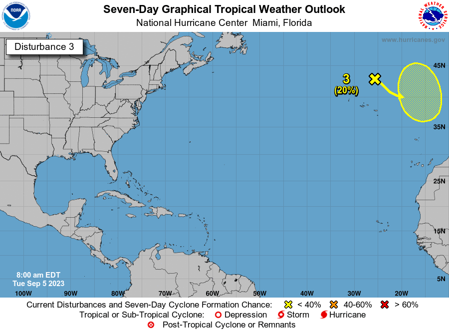
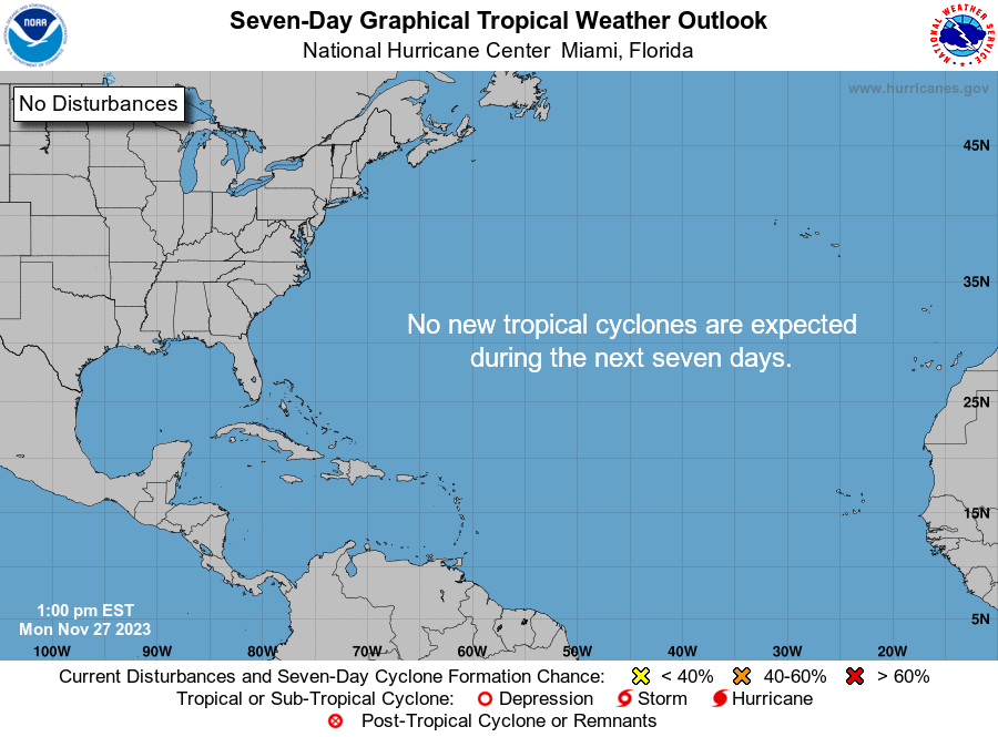
National Hurricane Center map: What are forecasters watching now?
Systems currently being monitored by the National Hurricane Center include:
Interactive map: Hurricanes, tropical storms that have passed near your city
Excessive rainfall forecast
What's next?
We will continue to update our tropical weather coverage daily. Download your local site's app to ensure you're always connected to the news. And look for our special subscription offers here.
This article originally appeared on Treasure Coast Newspapers: NHC: Tropical Storm Beryl forms, expected to become hurricane

