Over 2,000 structures evacuated as Thompson Fire grows near Oroville, Butte County sheriff says
Two wildfires that sparked Tuesday in Northern California have prompted mandatory evacuations amid bone-dry vegetation heated up by extremely high temperatures and gusty winds.
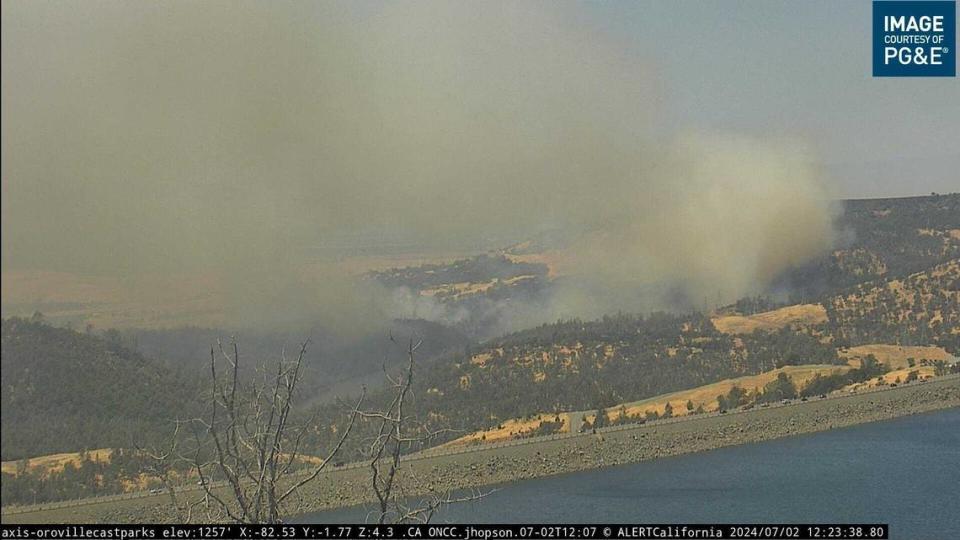
The Thompson Fire, which was reported shortly before 11 a.m. Tuesday on the outskirts of Oroville in Butte County, had burned at least 245 acres as of 1:49 p.m, according to Cal Fire. The area south of Oroville Lake and several miles downhill from areas that had been de-energized as part of PG&E’s public safety power shutoff around Concow.
Cal Fire officials said there was a spot fire that was about 30 to 40 acres across the diversion pool in the Lakeland Boulevard area. Cal Fire mapping of the blaze showed most of the fire was burning along on the north side of the Feather River, and spot fires were burning south of the river.
Authorities have issued more evacuation orders throughout the day, some of them well within the Oroville city limits, as the wildfire grew from 15 to nearly 250 acres within three hours of its start. A sheriff’s map of the evacuation orders shows about 2,500 structures sit within the mandatory evacuation zone.
Oroville Hospital at 257 Olive Highway is in zone 964, one of the zones that remained under an evacuation warning at 4 p.m. Tuesday. Raquel Harp, executive assistant to the chief executive officer at the hospital, said hospital staff was “sheltering in place and taking care of the patients.”
The Sheriff’s Office said zones 965 south of Highway 162, 804, 805, 811, 816, 806, 807, 801, 808, 809 and 810 also were under an evacuation warning due to the Thompson Fire.
At 11:35 a.m., the Butte County Sheriff’s Office issued a mandatory evacuation order for people in Zone 536 in the Cherokee area of Oroville due to the Thompson Fire. The evacuation order included the area of Cherokee Road north of Thermalito Power Canal and the area north past Big O Road to just south of Oregon Gulch Road.
Five minutes later the Sheriff’s Office issued an evacuation warning for people in Zone 731 in northeast Oroville. But that warning in Zone 731 was upgraded to a mandatory evacuation order shortly after noon Tuesday, according to the Sheriff’s Office.
Zone 731 includes the area of Feather River at the Diversion Dam, east to Oroville Dam Boulevard East Diversion pool, south to Long Bar Road/Brereton Way. The warning also includes the areas of Long Bar Court, Almond Street, Colina Way, Lausen Street, Lakeland Boulevard, Incline Avenue, Gold Avenue, Perkins Street and Reyman Street.
At 12:50 p.m., the Sheriff’s Office announced mandatory evacuation orders were issued for zones 534, 535, 953 and 954 in Butte County. A temporary evacuation shelter has been opened at the Oroville Church of the Nazarene at 2238 Monte Vista Ave. in Oroville, sheriff’s officials said.
As of 2:45 p.m. Tuesday, sheriff’s officials have issued evacuation orders for zones 965 north of Highway 162, 958, 959, 960, 730, 800, 851, 700 through 716; all areas southeast of where the fire was burning in Butte County. Only Zone 964 remains under an evacuation warning.
The Thompson Fire was burning just west of where the Bar Fire burned 36 acres since Thursday and was now 100% contained, according to Cal Fire.
The National Weather Service issued a red flag warning for areas of the Sacramento Valley and northern Sierra Nevada foothills. The warning, which is issued when there’s a forecast for a long period of dry weather creating potentially critical conditions for a wildfire, will be in effect from 11 p.m. Monday through 8 p.m. Wednesday.
Wind-driven fire in Napa County prompts evacuations
The Toll Fire, which started about 9:45 a.m. Tuesday off of Old Lawley Toll Road and north of Calistoga in Napa County, had burned about 50 acres and spreading in a southwesterly direction. Cal Fire officials said the Tolls Fire is wind-driven and burning side-slope along the terrain to the southwest and is still east of Silverado Trail. About 300 firefighters were battling the fire, which sparked south of parcels along the Napa-Lake county line that PG&E had shut off amid the high fire danger.
The #TollFire burning north of Calistoga remains at approximately 50 acres. Crews are actively engaged in the firefight and working to construct control lines from both the air and the ground. The fire remains at zero containment. pic.twitter.com/z7tfv5vRfD
— CAL FIRE LNU (@CALFIRELNU) July 2, 2024
About 12:45 p.m., Cal Fire officials said crews were actively engaged in the firefight and working to construct control lines from both the air and the ground. The Toll Fire at that point remained at 50 acres with no containment.
The Napa County Sheriff’s Office issued mandatory evacuation orders for zones NPA-E103 and NPA-E113, and evacuation warnings for zones NPA-E104 and NPA-E105. Cal Fire said more than 100 people were in the Toll Fire evacuation order and warning zones.
A cooling station and evacuation point has been set up at the Calistoga Community Center, 1307 Washington St.
Another blaze, the Denverton Fire, near Travis Air Force Base had charred at least 25 acres Tuesday but had prompted no evacuations by 1 p.m.
#TollFire: Firefighters are at scene of an approximate 10-acre vegetation fire northwest of Calistoga off Old Lawley Toll Road. The fire is wind-driven, mid-slope pushing down valley with short range spotting. pic.twitter.com/K3rXqUoak8
— CAL FIRE LNU (@CALFIRELNU) July 2, 2024

