Polar vortex-type cold wave could freeze parts of U.S. next week
After a historically mild November, the start of meteorological winter is shaping up to be extremely cold and snowy for parts of the North America, including the U.S.
For weeks now, ultra cold air has been building up in Siberia, as the polar vortex has been wobbling around like a bad figure skater, displaced outside of the Arctic. Now it appears the Russian Arctic will warm up dramatically, relative to normal at least, as North America cools off — potentially big time.
The frigid air is coming in two waves. The first is already spilling across the U.S. The second, potentially more potent one, is on tap for next week.
SEE ALSO: Google's data centers, offices will use 100% renewable energy in 2017
The Upper Midwest, parts of the Plains states, the Rocky Mountains and the Pacific Northwest are already being affected by the first cold burst of air. In some areas, temperatures are 20 to 30 degrees Fahrenheit below average for this time of year. By far the coldest air is setting up shop across Alberta, where daily highs are likely to remain below zero Fahrenheit through the end of the week.
In other areas it's just seasonably cold.
In the northern Rockies and northern Plains, high temperatures may stay in the single digits on Wednesday and Thursday this week, as the worst of the cold settles in.
The cold air mass will moderate somewhat as it shifts eastward, affecting the Mid-Atlantic and Northeast this weekend.
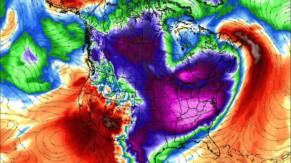
Upper-level atmosphere configuration very similar in scale & magnitude as infamous Jan 2014 #PolarVortex popularized by me and @afreedma pic.twitter.com/1YUZ4AtZRv
— Ryan Maue (@RyanMaue) December 6, 2016
Reminds me a touch of January 2015 type of pattern. Arctic air unleashed for many, but a pretty dry stretch to go with it. To start, anyway. pic.twitter.com/w2e3zNXxF9
— Eric Fisher (@ericfisher) December 6, 2016
Of greater interest, however, is what may lie ahead.
Some computer models are hinting at a potentially far more formidable shot of cold weather during the second week of December, with a lobe of the polar vortex rotating south out of Canada, into the Southeastern U.S.
Looking down on Northern Hemisphere, it's North America's turn for extreme cold — as Siberia/Asia feels relative warmth (above normal) pic.twitter.com/zYrFafuT1b
— Ryan Maue (@RyanMaue) December 6, 2016
The main polar vortex is a circulation of air enveloping a near-permanent area of low pressure that exists in the upper atmosphere, above typical cruising altitudes for commercial jetliners, over the Arctic.
When these winds weaken, as has been happening recently, pieces of the vortex can break off, and meander south into the U.S., Europe and parts of Asia.
What could this mean?
If the second Arctic blast is as impressive as some model runs are showing, then temperatures could fall well below average for this time of year, possibly more than 30 degrees below average across the Midwest, East and Southeast.
Meanwhile, in the West, milder Pacific air would move in, potentially leading to coastal rain and mountain snows.
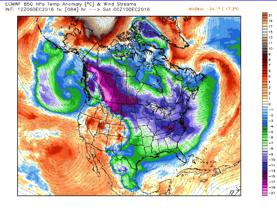
Image: weatherbell analytics
The GFS model is among the more aggressive ones projecting the second Arctic blast, showing high temperatures in the single digits along the East Coast by Dec. 16, and overnight lows well below zero. However, it has support from the more reliable Euro model as well, which lends this scenario more credibility (though still far from certainty).
Such severe cold so early in the season would be rare, and is typically only seen when a solid snowpack is in place to allow for more of the sun's heat to be reflected back out into space.
"Mid-December on the calendar can surely see extreme cold (and snow) but it's not quite the dead or middle of winter," said Ryan Maue, a meteorologist with WeatherBell Analytics, in a Twitter message with Mashable.
"Warmer, Pacific modified air will directly compete over the Western United States," Maue says. "This would mean beneficial rainfall for California coast and huge snowfall totals for mountains."
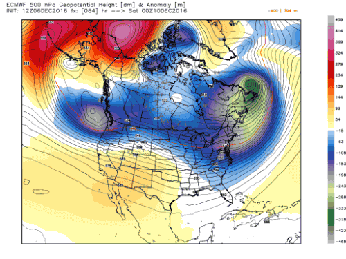
Image: weatherbell analytics
As for the track of the coldest air, Maue said the heart of the cold may track across the Ohio River Valley and into the Mid-Atlantic and Northeast.
"Current model tracks of the 'tropospheric polar vortex' are for the vorticity maximum at 500-mb to swing like a pendulum through Manitoba and Ontario with the coldest Arctic air on the backside reaching as far south as the Ohio River," Maue said.
To decode that a bit: The 500 millibar level he referred to equates to an altitude of about 18,000 feet. And vorticity essentially means atmospheric spin.
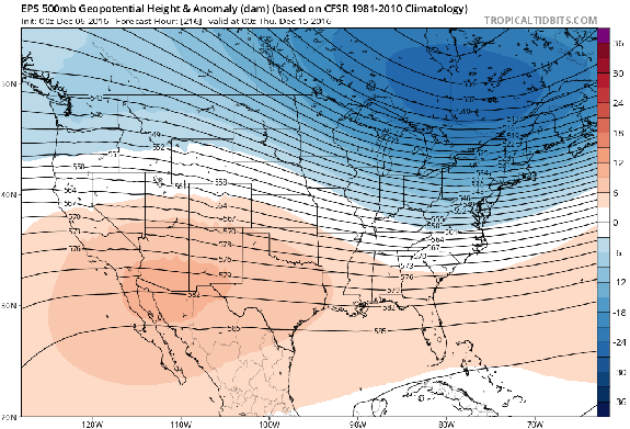
Image: tropicaltidbits.com
The details on this second cold air outbreak are unclear at this time, since it's at least a week away and some computer models are not showing the truly severe cold that others are.
However, the potential is there for a headline-grabbing bout of frigid weather that is similar in magnitude to the 2014 "polar vortex" winter event, when Chicago was nicknamed "Chiberia," and sea smoke was seen on the Hudson River in New York City.
However, before you freak out about weeks spent indoors and run to buy long underwear and a new North Face coat, wait a few days as the forecast evolves. Stay tuned for updates, and remember that the polar vortex is not some monstrous storm that invades your neighborhood, but rather describes weather patterns high in the atmosphere.
Still, just in case, maybe start pricing out vacation options in the Caribbean?
