
Powerful New Earth-Observation Satellite Snaps 1st Photos
NASA's latest Earth-observation satellite has snapped its first photos, continuing a four-decade effort by numerous spacecraft to track environmental change and resource use across the planet.
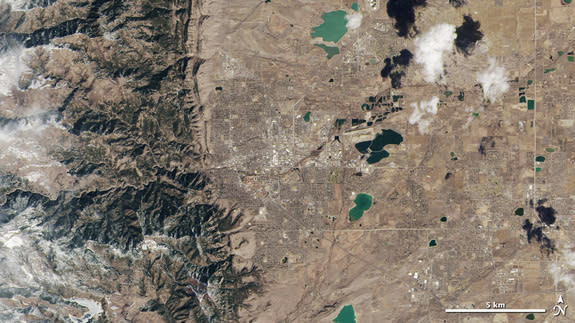
The Landsat Data Continuity Mission (LDCM), which launched Feb. 11, captured a series of images of the United States' Great Plains and Rocky Mountain region on Monday (March 18) using both of its onboard instruments.
"We are very excited about this first collection of simultaneous imagery," Jim Irons, LDCM project scientist at NASA's Goddard Space Flight Center in Greenbelt, Md., said in a statement today (March 21). "These images confirm we have two healthy, functioning sensors that survived the rigors of launch and insertion into Earth orbit."
The $855 million LDCM spacecraft is the eighth satellite in the history of the Landsat program, a joint NASA/United States Geological Survey (USGS) effort that has been monitoring Earth from above since Landsat 1 lifted off in 1972. [Photos: The Next Landsat Earth-Observing Spacecraft]
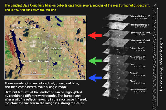
LDCM peers down at our planet with two instruments — the Operational Land Imager (OLI), which collects data in visible, near infrared and shortwave infrared wavelengths, and the Thermal Infrared Sensor (TIRS), which measures heat emitted from Earth's surface.
LDCM is the most capable and advanced Landsat spacecraft ever launched, mission officials say. Its observations will allow scientists to continue tracking urban expansion, global ice loss, natural resource use and other phenomena, adding to a dataset that goes back more than four decades.
Two of the new LDCM images show the regions around the Colorado cities of Boulder and Fort Collins, while another focuses on a stretch of wilderness in Colorado and Wyoming where the Great Plains meet the Rocky Mountains' Front Range.
Mission scientists are pleased with the quality of the images.
"Wow! This is beautiful!" Dennis Reuter, TIRS instrument scientist at NASA Goddard, said in a statement. "Look at those amazing clouds! And the detail!"
LDCM has been undergoing on-orbit testing since it blasted off six weeks ago. Everything is going well so far, scientists say, but more work needs to be done. Instrument calibration will take place over the next few weeks, and the satellite should begin normal operations in late May.
When that happens, LDCM will be renamed Landsat 8 and turned over to the USGS, which will operate the satellite for its planned five-year mission lifetime.
Mission scientists hope Landsat 8 lasts longer than five years, however. The satellite has enough fuel to sustain about a decade of operations, Irons has said, and its predecessor Landsat 7 continues to observe our planet nearly 14 years after its launch.
Follow Mike Wall on Twitter @michaeldwall. Follow us @Spacedotcom, Facebook or Google+. Originally published on SPACE.com.
Liftoff! Launch Photos for NASA's Advanced Landsat 8 Mission
Earth From Space: Landsat Satellites' 40-Year Legacy Explained (Infographic)
Copyright 2013 LiveScience, a TechMediaNetwork company. All rights reserved. This material may not be published, broadcast, rewritten or redistributed.
