
Super Typhoon Nepartak is an example of terrifying meteorological perfection
The western Pacific Ocean had been building up heat for a record 200 days without the churning from a single typhoon. The ocean basin that spawns the strongest storms on Earth had been oddly quiet, but it's making up for its slumber in a big way with Super Typhoon Nepartak.
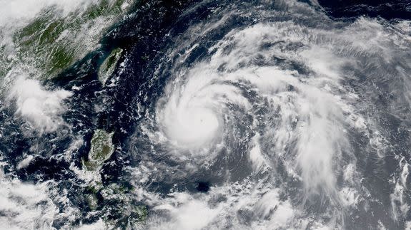
This storm, which had maximum sustained winds of 175 miles per hour as of Wednesday morning, is a beast.
SEE ALSO: Beastly Category 5 Super Typhoon Nepartak is headed right for Taiwan
At that time, it was as close to a textbook case of an intense typhoon as one typically sees in any season, or even multiple seasons, and it illustrates how these storms grow and sustain themselves by feasting on the energy drawn from a deep reservoir of warm ocean waters.
Based on satellite imagery, Super Typhoon Nepartak has struck many meteorologists as a near-perfect storm, to use the cliche phrase.
"There is a visual symmetry factor that goes into what makes a tropical cyclone appear as what we might call "perfect,"" said Anthony Sagliani, a meteorologist at Earth Networks in Maryland. "A small round eye in the center of the storm surrounded by a ring of massive, deep convection. Certainly Nepartak has that look. But to maintain that look the storm actually needs several parameters to coincide for several days," he said.
Hurricanes and typhoons (these are the same type of storms, but located in different parts of the world and called different things) are essentially giant heat engines, powered by the latent heat release from evaporating warmth and moisture from mild ocean waters as well as humid air masses.
Warm waters are present in abundance in the northwest Pacific Ocean at this point. Water temperatures in the Philippine Sea are above 86 degrees Fahrenheit, or 30 degrees Celsius.
"This is partly because the region had previously been untouched by a tropical cyclone for a record length of time," Sagliani said.
"Another parameter a storm like this needs in place is very low wind shear. From the get-go, Nepartak has been impacted by no more than 6-12 mph shear. Its convective towers have no problem sustaining themselves in that environment," Sagliani said in a Twitter message.
The warm waters plus low shear helped the storm catapult from Category 1 to Category 5 intensity within a 24-hour period. "The upper-level conditions were perfect for rapid/explosive intensification," said Ryan Maue, a meteorologist for the private weather firm WeatherBell Analytics, in an email.
"Ocean heat content is anomalously high along the track of Nepartak as well, likely contributing to the extreme intensification rates," Maue said.
The heat goes into fueling massive thunderstorms that are tightly packed around the center of the storm, in an area known as the central dense overcast, or CDO.
Through Wednesday morning eastern time, such a feature was readily apparent with Super Typhoon Nepartak. At the center of the CDO is the storm's eye, where the air is descending and the air pressure is the lowest. Nepartak features a relatively small eye, but that could change over time.
The storm has also taken on the appearance of a so-called "annular" tropical cyclone, with an absence of multiple spiral bands and the presence of a large, dense area of thunderstorms extending well out from the storm's center.
Also evident with this storm is its extraordinary "outflow channels" of air at upper levels of the atmosphere.

Image: University corporation for atmospheric research
According to Sagliani, the healthy outflow from this storm has been particularly noteworthy.
"I think what impresses me the most about Nepartak, is its ability to breathe. Nepartak has a massive set of lungs, with dual outflow channels stretching both poleward and equatorward through almost 30 degrees of latitude from northern edge to southern edge," he said.
Essentially, at upper levels of the atmosphere, there is an area of high pressure flowing counterclockwise, evacuating air from the storm.
Tropical cyclones lift a huge volume of air into the upper levels of the atmosphere, where the air cools and dries. It is therefore necessary for this air to be evacuated from the storm for hundreds to more than 1,000 miles away from the storm's center.

Image: RAMMB/CIRA/CSU
Reconnaisance aircraft are not flying into this storm as is the case for storms in the Gulf of Mexico and Atlantic Ocean, so we don't know exactly what the storm's intensity and minimum central air pressure is. The intensity most likely peaked on Wednesday morning eastern time, likely to be disrupted by internal dynamics prior to its arrival in Taiwan.
Meanwhile, meteorologists are using multiple methods using satellite imagery in order to estimate the storm's strength.
"Its near-perfect visual display should be taken as a warning like the gorgeous colors and intricate patterns we see on venomous snakes and fish," Sagliani said.
"While beautiful from the comfort of our computer screens, [it] is a real, life-threatening typhoon that should be met with utmost concern and preparation by those in its path."
Typhoon Nepartak is forecast to make landfall along the eastern coast of Taiwan on July 8 or 9 as a Category 4 or 5 storm, capable of causing extensive damage.
