Tech and data converge to create better maps about our shared worlds
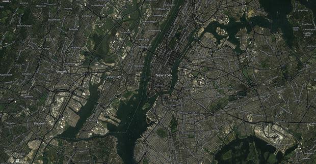
Screenshot of a Mapbox map of New York City
Image: Screenshot taken by Alex Howard
It's impossible to overstate the importance of maps to humanity, from our ancestors sketching the heavens on cave walls to ancient civilizations creating invaluable records of the known world, from trade routes to coastlines. For millennia, maps were painstakingly created through first-hand observation. As the instruments used to create cartography became more sophisticated, enabling measurements relative to the sun and stars, so did the accuracy of our maps, leading to commerce, warfare, and exploration of the oceans and skies on a scale that our ancestors never anticipated.
Today, hundreds of millions of people have near-magical maps in our pockets and palms and on our dashboards that are dynamically built upon data and show our position on the face of the Earth with extraordinary accuracy using the Global Positioning System (GPS). We also sometimes blindly trust those GPS systems too much, unfortunately: truck crashes into bridges have been sourced to consumer-grade GPS systems, and far too many drivers have followed GPS directions into danger.
As Apple discovered to its sorrow in 2012, creating accurate map applications isn't easy. While Apple Maps have improved in the years since, the "MAppleGate" episode cast some light on the importance of good data and software to delivering the navigational experience that consumers have come to expect. Behind the embarrassment, however, is a dynamic, shifting environment for geographic information systems (GIS) data and tools to build maps with it. When Google increased fees for API access to its mapping data in 2012, access to OpenStreetMap, the "Wikipedia of maps," became more relevant to a growing number of scrappy startups and resource-constrained media organizations.
Charting the course of CartoDB
News this month that Google could be winding down its Maps Engine will create more opportunities for startups and GIS giants like Esri to attract developers.
"With Google Maps Engine being deprecated, we just have a few competitors," said Javier de la Torre, the CEO of CartoDB, a Spain-based software startup, in an interview.
"Not only are new technologies appearing, but new business models," he mused. "There is a realization of software-as-a-service as a better model for serving software, enabling companies like us to essentially make a good business by providing the service without having to lock the customer in. Code is becoming less and less of a competitive advantage. What matters is the service to the customer, and that's driving the development of the technology. That's changing not only the approach of innovating. It's creating something useful that people want to use, that solves a real problem, then opening it so that anyone can implement it on their own system."
While many consumers and builders of online media know CartoDB as free software behind online maps, like the ClearStreets.org map I featured in my column on civic tech, its enterprise offering is what brings revenue. De la Torre told me that they have over 90,000 users on their platform, but their biggest customers are in the banking and financial industry, where their geospatial technology is used to analyze where transactions are happening and to target business strategy.
"We are in the business of helping people to visualize their data," said de la Torre.
It's not just business people that are driving revenue, either: CartoDB's second largest enterprise vertical is in the public sector, according to de la Torre. For instance, the U.S. National Park Service uses CartoDB to publish route maps in its parks through updates to the underlying data sources.
"When they update data on the website, the maps update in real-time," he said. "It changes how they maintain them. It's no longer someone creating a map and publishing it: the maps are just a representation of the latest state of data."
Open mapping
Mapbox, a venture-backed mapping software startup, is positioning itself to take on Google and Esri with terabytes of open satellite data. The startup is a poster child for a business driven by open data and open source technology.
"There is a convergence happening," said Eric Gundersen, the CEO of Mapbox, in an interview. "The open data the United States government has been producing is literally gaining value as tech improves, because we can do more with it. The maturing of open source tools and cloud infrastructure is letting a small team make a run at the mapping giants with world-wide architecture."
Mapbox, which received $10 million in venture funding in 2013, has 5,000+ paying subscribers and more than 225,000 people have accounts, according to Gundersen, and generates hundreds of millions of map views every month.
"The diversity of subscribers is crazy, from the likes of Foursquare, Evernote, and Pinterest to media outlets like USA Today and NPR, to the government like the FCC, Department of Energy, and the city of NYC during Hurricane Sandy," he told me. "We are trying to make mapping not just more social, but profitable. The traction is fueling great team growth. We are going to win because we are leveraging open source and open data. No one realizes how much of the stack we have built."
The power of open data
Gundersen is one of the biggest believers in the combined power of open source software, agile development, and open data that I met in my five years in Washington, DC. The last such project that Gundersen worked on before he moved to San Francisco to focus on Mapbox full-time, in fact, was HealthCare.gov, the front-end of which the Development Seed team helped build in their garage office in DC. (Mapbox grew out of Development Seed's work.) While various management issues, political decisions, and technical problems that plagued the back-end of HealthCare.gov led to its disastrous relaunch, that front-end held up fine.
De la Torre is similarly an evangelist for the expanding role of open source software in the mapping world. "I think it's fair to say right now that most of the innovation in the geospatial world is being driven by open source," he told me. "From new libraries to new tools for analyzing data, most of those developments are done in an open source world. It's not only the libraries themselves, but the code itself. We're moving from a previous state, where open source has been responsible for implementing open standards, where the community has realized it's time not just to follow the standards but innovate themselves."
The business that Mapbox has created from open government data has historical antecedents that go back to the 19th century, when the U.S. began publishing meteorological data that helped mariners navigate oceans around the world. Today, instead of log files, the U.S. government has sent terabytes of data to Mapbox on hard drives.
"Publicly funded projects have generated a ton of open data, and we're just starting to show their value to the general public," said Gundersen. "The NAIP [National Agriculture Imagery Program] is a crazy example: the USDA [U.S. Department of Agriculture] generates aerial photography down to 1 meter resolution of the entire United States for scientists to study farms. We're actually using the same NAIP aerial photography to generate a high zoom level map that Mapbox users can use to show their next coffee shop check-in. There's a ton of open datasets like NAIP, NASA Landsat, and USGS high-resolution orthoimagery that we are making relevant beyond the scientific community and putting in the hands of web and mobile app developers. We are talking about 100+ terabytes of data."
Mapping conflicts and conflicted borders
"There's an incredible correlation between what's going on in the news and what's created on the platform," he told me. "If there's a conflict in Ukraine, you may see a map within 30 minutes."
On that count, CartoDB features a gallery of interesting uses of its online mapping software. For instance, the International Consortium of Investigative Journalists used CartoDB to map the data behind its "Swiss Leaks" story, a massive investigation that brought to light secret bank accounts maintained by HSBC.
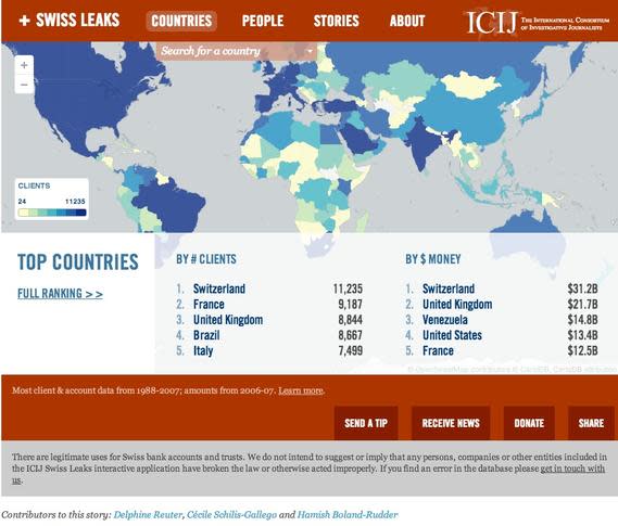
The ICIJ used CartoDB to map the data behind its "Swiss Leaks" story.
Image: Screenshot taken by Alex Howard
In the near future, de la Torre told me that CartoDB will launch a new part of the website that's focused on what's going on in the world.
"You will have the ability to copy maps, change them, and enable discussions around them," he said. "You can see already, for every map made, there's a public page for them. Conversations can get quite hot. Some of the things coming over the next month are about connecting more of the community."
When (and if) that goes live, things are likely to get even more interesting for the startup, just as they have for every other platform that hosts user-generated content around the world. He told me that that the company hasn't taken any map down so far, but has only passed the request to the primary user.
"Maps are a very sensitive thing from a geopolitical perspective," acknowledged de la Torre.
On that count, he highlighted something fascinating: national borders are changed based on location. For instance, people using Google Maps from Russia see something different than people using Google Maps from France. That puts the company in an interesting place, with respect to how it does or does not vouch for the validity of maps on its service.
"What we want to be is a platform for people to make maps," he said. "At the end of the day, they're a model of reality, but because they're so powerful, people take them as a representation of fact. They're not."
Also read
Editor's note: Specifics about Mapbox's subscribers and CartoDB user numbers were updated after the article's publication to reflect the latest information.
