Thunderstorms expected to hit Florida Friday, Saturday. Will it rain on Mother's Day?
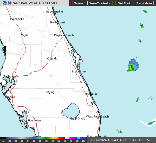
Summer weather has arrived with a vengeance, bringing days with real-feels in the upper 90s across parts of Florida, and thunderstorms are expected to sweep across North and Central Florida Thursday night through Friday bringing rain, hail, localized flooding and potentially tornadoes.
Are you and your mom going to need to take cover on Mother's Day this Sunday?
According to the latest forecasts from the National Weather Service, you might want umbrellas but only to protect yourselves from the blazing sun. Clear, sunny days are expected across the state with temperatures in the mid-to-high 80s with some areas such as Tampa and West Palm Beach reaching temps into the 90s.
However, severe thunderstorms across the Eastern Seabord Thursday and Friday may affect air travel so if any of the family is traveling be sure to keep an eye on your flight status.
If you're heading outside to enjoy the temperatures, be aware most of the state is seeing medium allergy levels, with low conditions reported in South and Southwest Florida, according to Pollen.com.
Weather watches and warnings issued across the U.S.
Weather alerts issued in Florida
Weather radar and forecast for Pensacola for Mother's Day

Storms at the end of the week should be cleared out by the weekend, forecasters said, leaving a partly sunny day Sunday with highs near 78. Then more rain is possible on Sunday night and Monday, according to the National Weather Service.
Pensacola weather forecast as of Thursday morning
Thursday night: A slight chance of showers and thunderstorms before 7 p.m., then a chance of showers and thunderstorms after 1 a.m.. Mostly cloudy, with a low around 75. South wind around 10 mph. Chance of precipitation is 40%.
Friday: Showers likely and possibly a thunderstorm before 1 p.m., then a chance of showers and thunderstorms after 1 p.m. Cloudy, then gradually becoming mostly sunny, with a high near 84. Southwest wind around 10 mph becoming west in the afternoon. Chance of precipitation is 60%. New rainfall amounts between a quarter and half of an inch possible.
Friday night: Partly cloudy, with a low around 66. North wind 5 to 10 mph.
Saturday: Sunny, with a high near 81. North wind around 10 mph becoming northwest in the afternoon.
Saturday night: Partly cloudy, with a low around 67. Northwest wind 5 to 10 mph becoming northeast after midnight.
Mother's Day: Partly sunny, with a high near 78. Northeast wind 5 to 10 mph becoming south in the afternoon.
Sunday night: A 20% chance of showers after 1 a.m. Mostly cloudy, with a low around 70. South wind 5 to 10 mph becoming east after midnight.
Monday: A 50% chance of showers and thunderstorms. Mostly cloudy, with a high near 77. East wind 10 to 15 mph, with gusts as high as 25 mph.
Follow National Weather Service Mobile on X, formerly known as Twitter
Weather radar and forecast for Tallahassee for Mother's Day

Mother's Day in the capitol should be dry and mostly sunny, with a high near 84, according to the National Weather Service Tallahassee.
Tallahassee weather forecast as of Thursday morning
Thursday night: Showers and thunderstorms likely, mainly before 4 a.m. Some of the storms could be severe. Mostly cloudy, with a low around 73. South southwest wind 5 to 10 mph, with gusts as high as 20 mph. Chance of precipitation is 60%. New precipitation amounts of less than a tenth of an inch, except higher amounts possible in thunderstorms.
Friday: A slight chance of showers and thunderstorms, then showers and possibly a thunderstorm after 8 a.m. High near 84. West southwest wind 10 to 15 mph. Chance of precipitation is 80%. New rainfall amounts between a quarter and half of an inch possible.
Friday night: Showers before 8 p.m. Low around 63. West wind 5 to 10 mph becoming north-northwest after midnight. Chance of precipitation is 80%.
Saturday: Sunny, with a high near 84. North wind 5 to 10 mph.
Saturday night: Mostly clear, with a low around 60.
Mother's Day: Mostly sunny, with a high near 84.
Sunday night: Mostly cloudy, with a low around 64.
Monday: A 30% chance of showers and thunderstorms after 2 p.m. Mostly cloudy, with a high near 83.
Follow the National Weather Service Tallahassee on X, formerly known as Twitter
Weather radar and forecast for Jacksonville for Mother's Day

Showers and thunderstorms are likely Thursday night through Friday night but the weekend should be mostly clear and sunny before more storms arrive on Monday. Temperatures are expected to be in the mid-80s, according to the National Weather Service Jacksonville.
Jacksonville weather forecast as of Thursday morning
Thursday night: Showers and thunderstorms likely, mainly before 9 p.m. Some of the storms could be severe. Cloudy during the early evening, then becoming partly cloudy, with a low around 76. Breezy, with a southwest wind 11 to 15 mph, with gusts as high as 23 mph. Chance of precipitation is 70%. New precipitation amounts of less than a tenth of an inch, except higher amounts possible in thunderstorms.
Friday: Showers and thunderstorms, mainly after 11 a.m. Some of the storms could be severe. High near 87. Breezy, with a southwest wind 13 to 18 mph, with gusts as high as 28 mph. Chance of precipitation is 80%. New rainfall amounts between a half and three-quarters of an inch possible.
Friday night: Showers and thunderstorms, mainly before 8 p.m. Some of the storms could be severe. Low around 69. Breezy, with a west wind 9 to 17 mph, with gusts as high as 26 mph. Chance of precipitation is 80%.
Saturday: Sunny, with a high near 84. North wind 6 to 11 mph, with gusts as high as 17 mph.
Saturday night: Mostly clear, with a low around 63.
Mother's Day: Mostly sunny, with a high near 85.
Sunday night: Mostly cloudy, with a low around 66.
Monday: A 30% chance of showers and thunderstorms after 2 p.m. Partly sunny, with a high near 84.
Follow the National Weather Service Jacksonville on X, formerly known as Twitter
Gainesville weather forecast for Easter weekend
Thursday night: A 20% chance of showers and thunderstorms before 9 p.m. Mostly cloudy, with a low around 73. Southwest wind 7 to 10 mph, with gusts as high as 16 mph.
Friday: Showers and thunderstorms, mainly after 3 p.m. Some of the storms could be severe. High near 88. Breezy, with a southwest wind 9 to 17 mph, with gusts as high as 26 mph. Chance of precipitation is 80%. New rainfall amounts between a tenth and quarter of an inch, except higher amounts possible in thunderstorms.
Friday night: Showers and thunderstorms likely, mainly before 7 p.m. Mostly cloudy, then gradually becoming mostly clear, with a low around 67. West wind 6 to 13 mph, with gusts as high as 20 mph. Chance of precipitation is 60%.
Saturday: Sunny, with a high near 86. Northwest wind 6 to 9 mph.
Saturday night: Mostly clear, with a low around 60.
Mother's Day: Mostly sunny, with a high near 86.
Sunday night: Mostly cloudy, with a low around 64.
Monday: A 40% chance of showers and thunderstorms after 2 p.m. Partly sunny, with a high near 87
➤ See the latest radar conditions for Gainesville.
Weather radar and forecast for Daytona Beach for Mother's Day
Daytona Beach isn't expected to see thunderstorms until possibly Friday night, but Mother's Day should be breezy, warm and dry with sunny skies and a high near 83, according to the National Weather Service Melbourne.
Chances for showers and thunderstorms increase on Monday.
Daytona Beach weather forecast as of Thursday morning
Thursday night: Mostly clear, with a low around 74. West-southwest wind around 10 mph.
Friday: A 40% chance of showers and thunderstorms, mainly after 2 p.m. Partly sunny, with a high near 91. West southwest wind 10 to 15 mph, with gusts as high as 25 mph.
Friday night: A 30% chance of showers and thunderstorms before 2 a.m. Mostly cloudy, with a low around 70. West wind 10 to 15 mph, with gusts as high as 20 mph.
Saturday: Mostly sunny, with a high near 83. North-northeast wind around 10 mph.
Saturday night: Mostly clear, with a low around 66. Northeast wind 5 to 10 mph.
Mother's Day: Sunny, with a high near 83. North wind 5 to 10 mph becoming east-northeast in the afternoon.
Sunday night: Partly cloudy, with a low around 70. Southeast wind around 10 mph.
Monday: A 30% chance of showers and thunderstorms after 2 p.m. Partly sunny, with a high near 82. East-southeast wind 10 to 15 mph, with gusts as high as 20 mph.
Follow the National Weather Service Melbourne on X, formerly known as Twitter
Weather radar and forecast for Orlando for Mother's Day
If you have big plans for a Mother's Day outing to Disney World, Universal Studios or any other theme parks in the area, you're in luck. While there's a chance of showers and thunderstorms coming through Friday evening and Saturday morning, it should clear up in time for a breezy, sunny Sunday with a high near 89, according to the National Weather Service Melbourne.
Winds are expected to start picking up later in the day and there is a 40% chance of showers and thunderstorms Monday afternoon.
Thursday night: Increasing clouds, with a low around 75. West southwest wind 5 to 10 mph.
Friday: A 20% chance of showers and thunderstorms after 2 p.m. Mostly sunny and hot, with a high near 95. West southwest wind 10 to 15 mph, with gusts as high as 25 mph.
Friday night: A chance of showers and thunderstorms between 8 p.m and 2 a.m, then a slight chance of showers. Mostly cloudy, with a low around 74. West wind 10 to 15 mph, with gusts as high as 25 mph. Chance of precipitation is 30%.
Saturday: A 10% chance of showers before 8 a.m. Mostly sunny, with a high near 91. Northwest wind 10 to 15 mph, with gusts as high as 20 mph.
Saturday night: Mostly clear, with a low around 68. Northwest wind 5 to 10 mph, with gusts as high as 20 mph.
Mother's Day: Sunny, with a high near 89. North northeast wind 5 to 10 mph.
Sunday night: Partly cloudy, with a low around 70. East-southeast wind around 10 mph.
Monday: A 40% chance of showers and thunderstorms after 2 p.m. Partly sunny, with a high near 89. East-southeast wind 10 to 15 mph, with gusts as high as 20 mph.
Follow the National Weather Service Melbourne on X, formerly known as Twitter
Weather radar and forecast for Melbourne for Mother's Day
The thunderstorms and showers are expected to reach the Melbourne area Friday night, with more possible Saturday, but Mother's Day is still expected to be hot and breezy with highs near 85, according to the National Weather Service Melbourne.
Winds will start picking up Sunday evening, the NWS said, and there's a 340% chance of thunderstorms Monday.
Melbourne weather forecast as of Thursday morning
Thursday night: Mostly clear, with a low around 73. South southeast wind around 10 mph becoming southwest after midnight.
Friday: Mostly sunny, with a high near 94. Southwest wind around 10 mph.
Friday night: A slight chance of showers and thunderstorms, then a chance of showers after 2 a.m. Partly cloudy, with a low around 72. West wind 10 to 15 mph, with gusts as high as 20 mph. Chance of precipitation is 30%.
Saturday: A 30% chance of showers, mainly before 8 a.m. Mostly sunny, with a high near 88. West northwest wind around 10 mph becoming north in the afternoon.
Saturday night: Mostly clear, with a low around 69. Northeast wind 5 to 10 mph.
Mother's Day: Sunny, with a high near 85. Northeast wind 5 to 15 mph.
Sunday night: Partly cloudy, with a low around 72. East-southeast wind 10 to 15 mph, with gusts as high as 20 mph.
Monday: A 40% chance of showers and thunderstorms, mainly after 2 p.m. Partly sunny, with a high near 85. East-southeast wind 10 to 15 mph, with gusts as high as 20 mph.
Follow the National Weather Service Melbourne on X, formerly known as Twitter
Lakeland weather forecast for Mother's Day
Thursday night: Increasing clouds, with a low around 72. West southwest wind 5 to 9 mph becoming light southwest after midnight.
Friday: Isolated showers and thunderstorms after 1 p.m. Mostly cloudy, then gradually becoming sunny, with a high near 94. Heat index values as high as 97. Breezy, with a west-southwest wind 6 to 15 mph, with gusts as high as 23 mph. Chance of precipitation is 20%.
Friday night: A 30% chance of showers and thunderstorms, mainly between 8 p.m. and 2 a.m. Partly cloudy, with a low around 73. West southwest wind 8 to 14 mph, with gusts as high as 21 mph.
Saturday: Mostly sunny, with a high near 92. West-northwest wind 6 to 11 mph, with gusts as high as 18 mph.
Saturday night: Mostly clear, with a low around 64. West northwest wind 8 to 13 mph, with gusts as high as 18 mph.
Mother's Day: Sunny, with a high near 92. North northeast wind 7 to 9 mph.
Sunday night: Partly cloudy, with a low around 68. Northwest wind 9 to 11 mph becoming east after midnight.
Monday: A 30% chance of showers and thunderstorms after 2 p.m. Partly sunny, with a high near 93. East wind 9 to 11 mph becoming south in the afternoon.
➤ See the latest radar conditions for Lakeland.
Weather radar and forecast for Port St. Lucie for Mother's Day
Some light rain Friday night and Saturday should clear up in time for a hot and sunny day Sunday, with highs near 87 and winds of 10 to 15 mph, with gusts as high as 20 mph, according to the National Weather Service Melbourne.
Weather forecast Port St. Lucie as of Thursday morning
Thursday night: Mostly clear, with a low around 71. South southeast wind 5 to 10 mph becoming southwest after midnight.
Friday: Mostly sunny and hot, with a high near 96. Southwest wind 10 to 15 mph.
Friday night: A 20% chance of showers after 2 a.m. Partly cloudy, with a low around 71. West wind 10 to 15 mph, with gusts as high as 20 mph.
Saturday: A slight chance of showers, with thunderstorms also possible after 2 p.m. Mostly sunny, with a high near 92. West wind around 10 mph, with gusts as high as 20 mph. Chance of precipitation is 20%.
Saturday night: A slight chance of thunderstorms before 8 p.m. Mostly clear, with a low around 68. North northwest wind around 10 mph. Chance of precipitation is 10%.
Mother's Day: Sunny, with a high near 87. North wind 5 to 10 mph becoming east in the afternoon. Winds could gust as high as 20 mph.
Sunday night: Partly cloudy, with a low around 71. East wind 10 to 15 mph, with gusts as high as 20 mph.
Monday: A 40% chance of showers and thunderstorms, mainly after 2 p.m. Partly sunny, with a high near 88. East-southeast wind 10 to 15 mph, with gusts as high as 20 mph.
Follow the National Weather Service Melbourne on X, formerly known as Twitter
Weather radar and forecast for West Palm Beach for Mother's Day

The bulk of the thunderstorms sweeping across Florida may be mostly in the north, according to the National Weather Service Miami, but the area may still see showers and thunderstorms Friday night and most of the day Saturday.
By Sunday the weather should clear up to be mostly sunny and breezy, with a high near 83. Winds are expected to pick up Sunday night, with gusts as high as 20 mph, and rain is expected Monday.
Weather forecast West Palm Beach as of Thursday morning
Thursday night: Partly cloudy, with a low around 77. Windy, with a south wind 17 to 26 mph, with gusts as high as 30 mph.
Friday: Sunny, with a high near 90. Breezy, with a southwest wind 13 to 18 mph, with gusts as high as 22 mph.
Friday night: A slight chance of showers between 2 a.m and 5 a.m., then a slight chance of showers and thunderstorms after 5 a.m. Mostly clear, with a low around 77. Breezy, with a west wind 18 to 20 mph. Chance of precipitation is 20%.
Saturday: A slight chance of showers and thunderstorms before 8 a.m, then a chance of showers between 8 a.m. and 11 a.m., then a chance of showers and thunderstorms after 11 a.m. Mostly sunny, with a high near 88. Breezy, with a west wind 11 to 16 mph. Chance of precipitation is 40%.
Saturday night: A chance of thunderstorms before 8 p.m. Partly cloudy, with a low around 76. West wind around 14 mph becoming north after midnight. Winds could gust as high as 18 mph. Chance of precipitation is 30%.
Mother's Day: Mostly sunny, with a high near 83. North wind around 11 mph becoming east in the afternoon.
Sunday night: Partly cloudy, with a low around 78. Southeast wind 11 to 13 mph, with gusts as high as 20 mph.
Monday: A 40% chance of showers and thunderstorms, mainly after 2 p.m. Mostly sunny, with a high near 83. Breezy, with a southeast wind 13 to 16 mph, with gusts as high as 22 mph.
Follow the National Weather Service Miami on X, formerly known as Twitter
Weather radar and forecast for Naples for Mother's Day
There's a slight chance of showers and thunderstorms overnight Friday through Saturday night, according to the National Weather Service Miami. But by Sunday Naples should see a breezy, sunny day with a high near 88, with possible thunderstorms coming back Monday.
Naples weather forecast as of Thursday morning
Thursday night: Partly cloudy, with a low around 75. South wind 6 to 8 mph.
Friday: Mostly sunny, with a high near 88. Southwest wind 7 to 10 mph.
Friday night: A 20% chance of showers after 2 a.m. Partly cloudy, with a low around 77. West wind 6 to 8 mph.
Saturday: A slight chance of showers, then a chance of showers and thunderstorms after 2 p.m. Mostly sunny, with a high near 86. West wind 7 to 14 mph, with gusts as high as 21 mph. Chance of precipitation is 30%.
Saturday night: A 30% chance of showers and thunderstorms before 8 p.m. Mostly clear, with a low around 71. North wind around 10 mph.
Mother's Day: Sunny, with a high near 88. North wind 7 to 9 mph becoming west in the afternoon.
Sunday night: Partly cloudy, with a low around 73. West wind 8 to 11 mph becoming east after midnight.
Monday: A 30% chance of showers and thunderstorms after 2 p.m. Mostly sunny, with a high near 90. East wind 9 to 11 mph becoming south in the afternoon. Winds could gust as high as 18 mph.
Follow the National Weather Service Miami on X, formerly known as Twitter
Weather radar and forecast for Fort Myers for Mother's Day

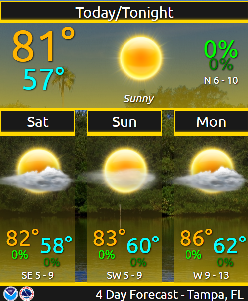
A rainy, stormy Friday night and Saturday is expected to lead to a hot sunny Sunday with a high near 92, according to the National Weather Service Tampa Bay. The forecast calls for mild winds picking up toward the evening with a 30% chance of showers and thunderstorms Monday.
Fort Myers weather forecast as of Thursday morning
Thursday night: Increasing clouds, with a low around 74. West southwest wind 5 to 9 mph becoming light and variable after midnight.
Friday: Sunny, with a high near 91. Southwest wind 6 to 11 mph.
Friday night: A 20% chance of showers and thunderstorms after 2 a.m. Mostly clear, with a low around 77. West wind around 8 mph.
Saturday: A 30% chance of showers and thunderstorms, mainly after 2 p.m. Mostly sunny, with a high near 90. West wind 6 to 13 mph, with gusts as high as 20 mph.
Saturday night: A 30% chance of showers and thunderstorms before 8 p.m. Mostly clear, with a low around 68. West northwest wind 7 to 11 mph, with gusts as high as 18 mph.
Mother's Day: Sunny, with a high near 92. North-northeast wind 6 to 9 mph becoming west-southwest in the afternoon.
Sunday night: Partly cloudy, with a low around 72. West wind 8 to 13 mph becoming east after midnight. Winds could gust as high as 18 mph.
Monday: A 30% chance of showers and thunderstorms after 2 p.m. Mostly sunny, with a high near 93. East wind 9 to 11 mph becoming south-southwest in the afternoon.
Follow the National Weather Service Tampa Bay on X, formerly known as Twitter
Weather radar and forecast for Sarasota for Mother's Day
A rainy, stormy Friday night and Saturday is expected to lead to a hot sunny Sunday with a high near 92, according to the National Weather Service Tampa Bay. The forecast calls for mild winds picking up toward the evening with a 30% chance of showers and thunderstorms Monday.
Sarasota weather forecast as of Thursday morning
Thursday night: Mostly cloudy, with a low around 77. Southwest wind 6 to 11 mph.
Friday: Mostly sunny, with a high near 83. Breezy, with a southwest wind 10 to 17 mph.
Friday night: A 30% chance of showers and thunderstorms, mainly before 2 a.m. Partly cloudy, with a low around 77. West-southwest wind around 11 mph.
Saturday: A 10% chance of showers and thunderstorms before 8 a.m. Mostly sunny, with a high near 83. Breezy, with a west-northwest wind 10 to 16 mph.
Saturday night: Mostly clear, with a low around 70. Northwest wind 9 to 13 mph.
Mother's Day: Sunny, with a high near 84. North northeast wind 7 to 10 mph becoming west-northwest in the afternoon.
Sunday night: Partly cloudy, with a low around 72. Northwest wind 9 to 11 mph becoming east-northeast after midnight.
Monday: A 30% chance of showers and thunderstorms after 2 p.m. Mostly sunny, with a high near 86. East-southeast wind 10 to 13 mph becoming south-southwest in the afternoon.
Follow the National Weather Service Tampa Bay on X, formerly known as Twitter
This article originally appeared on The Daytona Beach News-Journal: Mother's Day 2024 Florida weather forecast: What to expect
