U.S. storm Arthur to pack hurricane winds by July 4 holiday
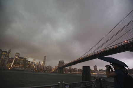
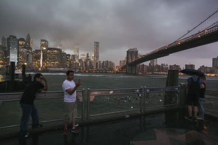
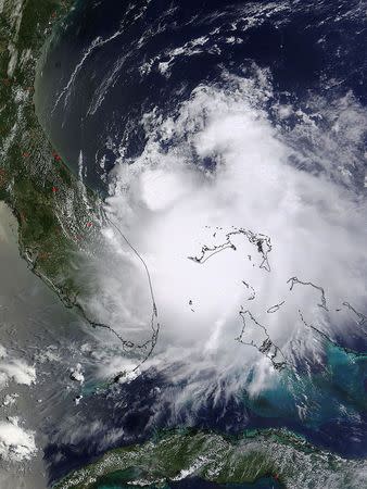
By Colleen Jenkins and Gene Cherry (Reuters) - Tropical Storm Arthur threatened to douse some July 4 holiday plans on the U.S. East Coast as officials in several states closed beaches and tourist sites and delayed fireworks shows in anticipation of heavy rain and fierce winds. The first named storm of the Atlantic hurricane season (http://link.reuters.com/baw32w) was close to reaching hurricane strength, forecasters said on Wednesday, leaving some businesses worried about taking a financial hit. Local officials predicted the storm would have little impact on tourism spending. Dave Dawson, owner of the Cape Hatteras Motel on North Carolina's Hatteras Island, which was in the storm's path, said he had no cancellations despite predictions of a soaked holiday. "Most of the calls I am getting are just wanting to make sure they can still come," Dawson said. "And of course, at this time you don't know what to tell them." A hurricane warning was in effect along North Carolina's coast, while part of the South Carolina shore was under a tropical storm warning, the National Hurricane Center said. Arthur was expected to become a hurricane on Wednesday night or Thursday as it passes well east of Florida's northeast coast, the NHC said. A tropical storm becomes a hurricane when top sustained winds reach 74 mph (119 kph). The storm remained out at sea with maximum sustained winds of 70 mph (113 kph) on Wednesday, about 220 miles (355 km) south-southeast of Charleston, South Carolina, the Miami-based weather forecasters said. Arthur could be packing Category 1 hurricane-force winds of 85 mph (135 kph) when the outer bands brush the Carolinas on Thursday and Friday before weakening, according to forecasters. The storm could produce dangerous rip currents along the coasts of several Southern states, forecasters said, dumping up to 2 inches (5 cm) of rain across the Carolinas and causing flooding from storm surge. HOLIDAY CELEBRATIONS AFFECTED Concerns about the storm caused authorities in Boston to move a nationally televised concert by the Boston Pops and fireworks display, which draw hundreds of thousands of spectators to the city's riverfront, up by a day to Thursday. Several towns and villages on North Carolina's Outer Banks and coast rescheduled Independence Day festivities and fireworks plans as the storm picked up speed moving north at 7 mph (11 kph). Farther up the coast, the resort town of Ocean City, Maryland, said it was moving its July 4 fireworks display to Saturday because of the storm. North Carolina Governor Pat McCrory declared a state of emergency on Wednesday for 25 eastern counties to help prepare for possible damage. A voluntary evacuation order was issued for low-lying Ocracoke Island, a popular summer tourist destination reached only by ferry or plane. "It doesn't look like it is going to be anything too bad," said Hyde County Commissioner John Fletcher. "We might get a little water from flooding." The National Park Service ordered the evacuation by 5 p.m. (2100 GMT) on Wednesday of visitors from the narrow barrier islands of the Cape Lookout National Seashore on North Carolina’s central coast. In the more populous Cape Hatteras National Seashore to the north, where up to 200,000 visitors crowd North Carolina’s Hatteras and Ocracoke islands, the park service began closing campgrounds, lighthouses and beaches at noon (1600 GMT) on Wednesday. (Reporting by Colleen Jenkins in Winston-Salem, North Carolina, and Gene Cherry in Raleigh, North Carolina; Additional reporting by David Adams in Miami, Harriet McLeod in Charleston and Scott Malone in Boston; Editing by Susan Heavey, Eric Beech and Peter Cooney)
