Florida, Gulf Coast facing potentially dire hurricane scenario, but details unclear
UPDATE: Aug. 25, 2016, 9:05 a.m. EDT The tropical wave known as "Invest 99L" continues to be a disorganized system, with windswept rains pounding Puerto Rico, Haiti and the Dominican Republic on Thursday. The storm is in an unfavorable environment for further development on Thursday, but could become a tropical depression or tropical storm by this weekend. It is increasingly clear that the storm will impact Florida in some ways, mainly through heavy rain and gusty winds, but it is unclear how intense the storm will be at that point. After its encounter with Florida, it's possible the storm will intensify into a hurricane in the Gulf of Mexico. In other words, all scenarios remain on the table as of Thursday morning.
UPDATE: Aug. 24, 2016, 2:40 p.m. EDT Hurricane Hunter aircraft flying through the tropical wave found tropical storm force winds are present at the surface, but that the system still lacks a closed low pressure area, which is a prerequisite to being considered a tropical depression or tropical storm.
The National Hurricane Center said there are "... large uncertainties regarding this system's development and future track..." but that it could become a tropical storm or depression in the coming days.
Original story below.
On Wednesday, a broad area of low pressure, accompanied by showers and thunderstorms, is sweeping towards Puerto Rico. However, it's what happens to this storm system after its encounter with the U.S. territory that is concerning weather forecasters and Gulf Coast residents from Miami to Brownsville, Texas.
As of Wednesday morning, all forecast scenarios were still on the table, meaning this could become tropical storm or even Hurricane Hermine within the next five days.
Or it could fizzle out completely — though that's becoming less likely with time.
SEE ALSO: Connecting the dots on 2016’s extreme summer weather and global warming
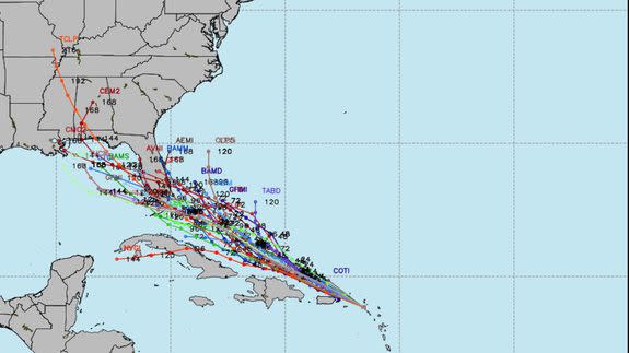
The stark differences between these two scenarios — as seen in the inability of major computer models to converge on a particular forecast solution — has meteorologists popping Tums.
Here's the bottom line: There's a real possibility that a tropical storm or hurricane (which would be named Hermine) will gather strength near the Bahamas before crossing the Florida peninsula late this weekend and then moving into the Gulf of Mexico early next week.
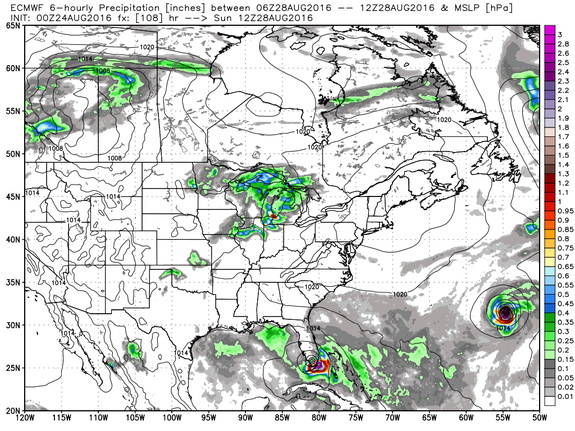
Image: weatherbell analytics
Given the near-record warm ocean waters in the Caribbean and Gulf of Mexico, it's possible such a storm would rapidly intensify into a powerful hurricane before making a second landfall anywhere from Texas to Florida's west coast.
No hurricane has struck Florida since 2005, and it's possible this one will end the state's lucky streak.
However, at this point, it's unclear if the storm will survive its interaction with the mountains of Hispaniola during the next two days, let alone atmospheric wind shear which typically inhibits tropical cyclone development.

Image: tropicaltidbits.com
In addition, storm track forecast errors for 120 hours, or 5 days, in advance average about 221 miles, based on data from 2011 to 2015. Storm intensity forecasts this far in advance are also highly uncertain.
Air Force Reserve hurricane hunter aircraft are on their way to examine the storm, which is currently known as "Invest 99L."
They will try to determine if the area of disturbed weather has formed a closed area of low pressure at the surface and in the lower atmosphere, at which point it would be on its way to being declared a tropical depression.
With so many questions, what should you do?
This storm puts weather forecasters and communicators in an awkward position — warning of potentially dire storm scenarios without fully buying into them yet.
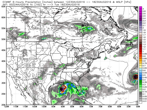
Image: weatherbell analytics.
It's prudent at this point to talk about the possibility of a significant hurricane hitting Florida, where there are at least 2 million more people now than there were in 2005, giving the state a significant hurricane amnesia issue that could complicate emergency preparedness efforts.
There are now 307,245 more people living in Miami-Dade county alone, for example, compared to 2005.
Hurricane preparations take time, and at this point, residents of states including Florida need to start thinking about getting ready by gathering recommended supplies, developing evacuation supplies, and more.
The storm's fate won't become clearer until either late Wednesday or, more likely, Thursday.
But with plenty of unusually warm ocean waters in its potential path, the window to prepare for it may close rather quickly given the potential for rapid intensification (assuming optimal atmospheric conditions are present, too).
One thing that is clear is the general path that any storm would take. Given a building area of high pressure across the Carolinas this weekend, any tropical weather system would be steered northwest and then west, into Florida and the Gulf of Mexico.
So the wild card here is a huge one — whether the storm will survive its interaction with land areas today and Thursday, and then whether it intensifies soon after that.
Stay tuned.
This is a developing story.
