
What's Causing the Epic Thanksgiving Storm
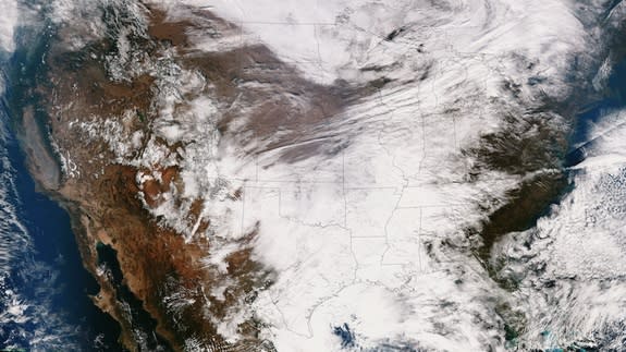
A messy winter storm is moving across the eastern half of the United States, threatening to delay drivers and fliers right before Thanksgiving Day, one of the busiest travel times of the year.
Weather forecasters say a few key atmospheric components joined forces to create this meteorological misery.
The storm is actually the same upper level low-pressure system, or trough (essentially a dip in the jet stream), that tore over the Southwest over the last few days, Brian Hurley, a meteorologist with the National Weather Service said. The storm dumped nearly a foot of snow in parts of northern New Mexico, prompted hundreds of flight cancellations in Texas and caused several deadly traffic accidents across the region, the Los Angeles Times reported.
Now that it's moving east, the storm is pulling in more moisture from the Gulf of Mexico and the Atlantic Ocean.
"It's just now getting to the point where once it gets to the Gulf region, it has more moisture to work with," Hurley told LiveScience Tuesday morning (Nov. 26).
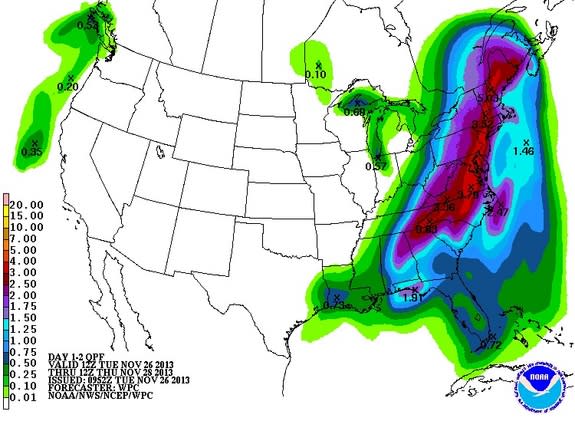
That means a large swath of the eastern United States, from Tennessee to Maine, could see heavy precipitation. Through Thursday morning, the system is expected to unleash between 2 and 4 inches (5 to 10 centimeters) of rain on average, with some areas likely seeing more, said Patrick Burke, another NWS forecaster.
But residents across the Appalachian Mountains and Great Lakes will likely see snow instead of rain. Several days ago, the storm system was joined by cold air that plunged down out of Canada, setting the stage for wintry precipitation, Burke said.
While coastal cities like New York and Boston will have a "pretty miserable couple of days," Burke said cities farther inland, such as Pittsburgh, Cincinnati and Buffalo, N.Y., will bear the brunt of the storm.
Hurley explained that these systems "like to go along the path of least resistance, like a railroad track." And for storms, that path is the one with the most moisture and warmth, which is why they tend to move just off the East Coast. This storm, however, is tracking farther inland because of the orientation of the upper level trough, Hurley said.
"What happens aloft can dictate the low track," Hurley told LiveScience. "In this case, there's just a stronger, deeper trough aloft."
The track of the storm means that warmer air will be pushed up the East Coast, so some cities closer to the shore will likely be spared from the cold temperatures the storm is expected to bring inland.
"In Washington, D.C., we'll feel it tonight and tomorrow," Hurley said. "It's going to be pretty humid for late November."
But the East Coast likely won't be spared from the blustery weather. Hurley said there will be strong winds on either side of this low pressure system.
NWS forecasters have predicted northwest winds will be blowing 18 to 23 mph (29 to 37 km/h), with gusts as high as 37 mph (60 km/h), on Thanksgiving (Nov. 28) in New York. Those conditions threaten to ground the balloons in Macy's Thanksgiving Day Parade, The Wall Street Journal said.
Those traveling over the next several days should check with their local National Weather Service office for updates and weather advisories, forecasters advise.
Follow Megan Gannon on Twitter and Google+. Follow us @livescience, Facebook & Google+. Original article on LiveScience.
Copyright 2013 LiveScience, a TechMediaNetwork company. All rights reserved. This material may not be published, broadcast, rewritten or redistributed.
