
You're probably not going to like the forecast for this winter
Despite a record-setting heat wave across much of the U.S. this week, winter is coming.
Two key winter forecasts are out, and they show completely different outcomes. Overall, the message is this: Don't panic about another frigid winter, as there's still considerable uncertainty.
But, there are signs this will be a colder and snowier than average winter for many people.
SEE ALSO: So that's 3 presidential debates, 0 climate change questions
First, let's set the bigger picture for this winter.
Seasonal climate forecasters rely on large-scale factors like sea surface temperature patterns across the Pacific and Atlantic Oceans to help determine what the dominant weather patterns may be during a particular season.
And for this winter, the biggest clue is that there is likely to be a weak La Niña event in the tropical Pacific Ocean.
You can think of La Niña as a sibling of El Niño. Instead of unusually warm ocean waters in the central and eastern tropical Pacific, La Niña events have cooler waters in these regions.
The weak La Niña predicted for this winter heavily influenced the 2016-17 winter outlook that the National Oceanic and Atmospheric Administration (NOAA) released on Thursday.
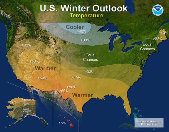
Image: NOAA
NOAA: Bad news on drought
According to NOAA, drier and milder than average conditions will be the rule across much of California, which is terrible news for the drought-riddled state. The state's worst drought on record is likely to intensify further during this winter, according to NOAA, potentially forcing the state to reinstate emergency water use restrictions.
“The winter forecast doesn’t bode well for this region,” said Mike Halpert, the director of the Climate Prediction Center in Maryland, on a Thursday conference call with reporters.
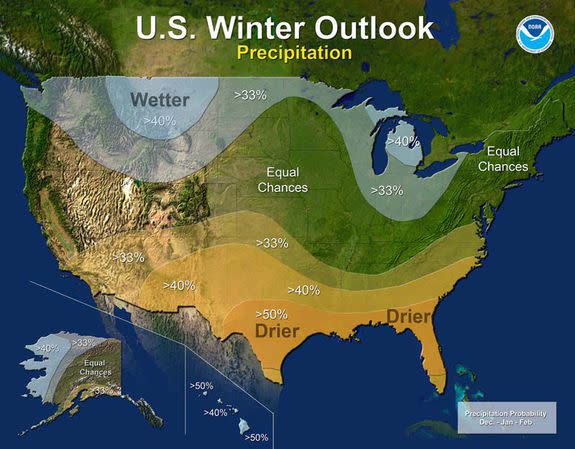
Image: noaa
In addition, according to the NOAA outlook, the Southwest is likely to be drier and milder than average, with dry and mild conditions extending eastward along the Gulf Coast all the way to Florida.
Wetter than average conditions are most likely in the northern Rockies, around the Great Lakes, in Hawaii and in western Alaska, according to NOAA's outlook.
The only colder than average conditions that NOAA predicts are where very few people live, in the northern Rockies.
For the rest of the country, including the Plains, Northeast, Mid-Atlantic, much of the Midwest and Rocky Mountain states, NOAA is predicting equal chances of a colder than average, average, or milder than average winter. The same goes for these regions and precipitation.
Because the La Niña is likely to be a weak event, NOAA's forecasters hedged their bets in a way that makes this forecast relatively unhelpful for tens of millions of people.
However, before you turn to the inaccurate Old Farmer's Almanac for more specific help, there is another forecast that is worth taking into account.
Cold and snowy winter for many?
Another prominent winter forecast released this week paints a very different picture from NOAA's. This prediction is based not just on La Niña, but also an indicator located more than 4,000 miles from New York City.
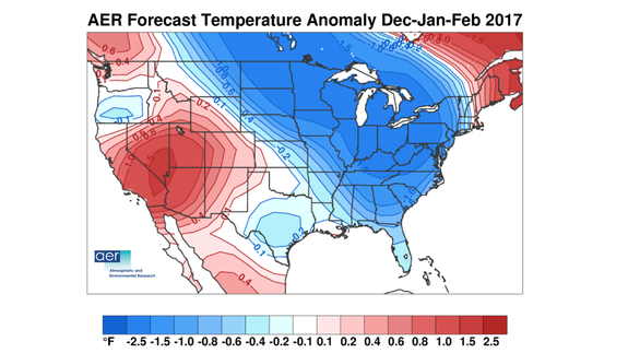
Image: NSF/AER
Meteorologist Judah Cohen, of the private forecast firm Atmospheric and Environmental Research in Massachusetts, relies on Siberian snow cover in the month of October to discern how key weather patterns will likely evolve downstream, above North America and Europe, during the winter.
Cohen thinks this winter is going to be a predominantly cold and snowy one from the northern Plains to the Upper Midwest on southeast to the Mid-Atlantic and Northeast. This would include big cities such as Chicago, Detroit, Boston, New York and Washington, D.C.
He agrees with NOAA that the West and Southwest, particularly California, is likely to remain warmer and drier than average.
Cohen's model uses Siberian snow cover patterns during the fall to predict the dominant phase of the Arctic Oscillation during the winter. Cohen's predictions have been uncannily accurate for several of the winters during the past decade, particularly when it comes to calling for cold and snowy winters along the East Coast.
Image: NSF/AER
Image: NSF/AER
Winters with a predominantly negative Arctic Oscillation tend to be cold and snowy across the eastern U.S., with blocking areas of high pressure forming across the northern latitudes, forcing cold air southward.
Cohen's work has linked Eurasian snow cover during October, and specifically the rate at which this snow cover expands during the month, to the evolution of the Arctic Oscillation.
When snow cover builds up quickly during October, a predominantly negative wintertime Arctic Oscillation is more likely, Cohen's work shows, owing to a complex series of interactions between the surface and the atmosphere.
“I think there’s a pretty robust signal coming out of the snow cover so far that I’m fairly confident [in this outlook]" Cohen told Mashable in an interview.
Cohen thinks one of the reasons the Mid-Atlantic and Northeast have seen snowier winters in recent years is because of the loss of Arctic sea ice, which is altering snow fall cover in Eurasia and affecting global weather patterns.
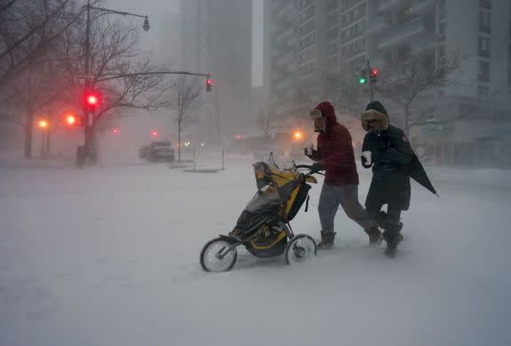
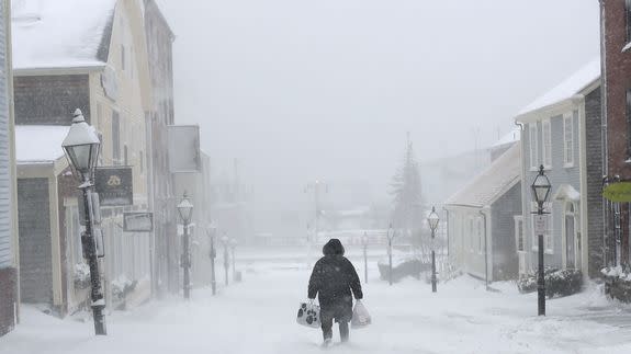
Image: Craig Ruttle/AP
“Intuitively it makes sense to tie it to the disappearing sea ice,” he said. “I haven’t found the smoking gun,” he added, noting that many scientists disagree with him regarding this hypothesis.
In September, Arctic sea ice reached the 2nd lowest extent on record since satellite records began in 1979. Cohen says sea ice is well below average in areas along the northern Eurasian coast, which he thinks is adding moisture to the atmosphere and leading to a faster buildup of snow cover.
Other forecasters in addition to Cohen are leaning toward a colder, snowier winter in the East, including WeatherBell Analytics and the Commodity Weather Group.
However, NOAA doesn't quite buy into Cohen's methods. Halpert said the relationship between Siberian snow cover and the Arctic Oscillation is too weak to be a reliable predictor of winter weather.
“They’re just not meeting the statistical significance that we look for,” he said. (That's scientific code for "your method is dubious.")
Of Siberian snow cover influencing winter weather in the U.S., Halpert says, “In my own view, [it] contributes some small degree of variance."
“I guess they’re not convinced,” Cohen said of NOAA's view. “That’ll continue to be I guess [the] disagreement between them and us.”
