Hurricane Hunters will fly over tropical wave causing ‘growing concern’ on the Gulf Coast
Hurricane Hunters from Biloxi will fly a U.S. Air Force plane over the Atlantic Ocean on Wednesday to survey a storm system that’s expected to strengthen into a tropical depression in the next two days.
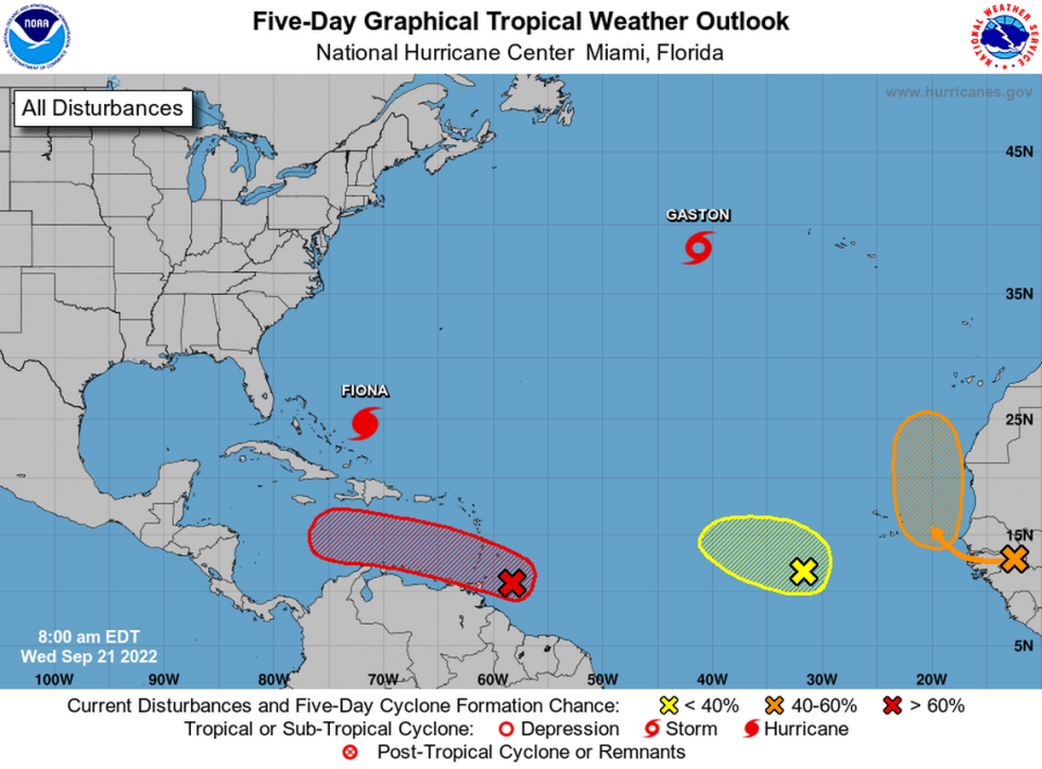
Invest 98L is producing showers and thunderstorms near the southern Windward Islands and is getting better organized, the National Hurricane Center said in its 1 p.m. CST update.
The tropical wave has a 70% chance for development into a depression within the next 48 hours, forecasters say. Invest 98L will dump heavy rainfall on parts of Venzuela and Colombia later this week, the NHC said.
Long-range models, which can often change, show the wave moving through the Caribbean strengthening into a major hurricane next week in the Gulf of Mexico.
Scot Pilié, a meteorologist with the Weather Channel, said Wednesday that the storm system is causing “growing concern.”
“Interests on Gulf Coast should be closely watching,” Pilié said, noting that it’s too far out to predict landfall.
“Fronts coming south could allow for a path more towards eastern Gulf/Florida, but simply too much uncertainty to write any path in stone,” he said.
Pilié said the storm has potential “for very quick” intensification down the line, as it could “move over some of the highest oceanic heat in the entire Atlantic Basin.”
Speed bump for tropical development
A speed bump for the development of invest 98, as it’s called until it earns a name, is the after burn from Hurricane Fiona, which slammed Puerto Rico and the Dominican Republic with torrential rains and 85 mph winds on Sunday and Monday.
Fiona, now a Category 4 bearing down on Bermuda, sucked up all the moisture in the air, leaving patches of dry air in its wake, which isn’t good for storm development.
As the storm moved north, wind shear wrapped around its southern tail, where it will likely interfere with the tropical wave’s development for the next day or two, Craig Setzer, a former CBS4 meteorologist turned weather vlogger, said in a Youtube broadcast about the disturbance.
“It may not stop it, it may not develop any more than a strong tropical wave as it enters the Caribbean ... but it’s a temporary limiting factor,” he said.
Here's what we know so far about tropical activity in the #Gulf late next week. #98L pic.twitter.com/DyctDw0o3x
— Jeff Huffman (@HuffmanHeadsUp) September 20, 2022
Are you prepared for a hurricane?
Pilié said residents from Louisiana to Florida should begin simple hurricane prep and make sure their plans are in place as a cautionary measure.
“We have a LONG time to continue watching this, but it doesn’t hurt to be prepared, just in case!” he said on Facebook.
With Fiona departing, all eyes on a tropical wave to the south. Could it affect Florida?
Forecasters area also watching two other areas of development coming off the coast of Africa.
The wave in the eastern tropical Atlantic has a 50% chance of development over the next five days, while the system in the east central tropical Atlantic has a 30% chance in the same time period.
The next named storm will be Hermine.
Miami Herald reporter Alex Harris contributed to this report.

