Hurricane Ian Wednesday updates: Lee schools closed rest of week; Lee issues boil water notice
Editor's Note: As a public service, The News-Press is making its storm coverage free to readers as long as the region is threatened. To help us continue keeping you informed, please consider supporting us with a subscription.
Stay informed: Sign up to a special texting group for updates on Hurricane Ian and its aftermath
6:30 p.m. | Collier, Lee schools now closed for rest of week
Collier and Lee schools announced they will remain closed through the end of the week.
All school district sites will be closed, all after school-programs canceled. All extracurricular activities including athletic practices and competitions are cancelled. All adult and community education classes will be cancelled. All district leases will be suspended.
The district will decide before 1 p.m. Sunday on the district's operations for Monday.
At this time, there will be no hurricane make-up days. Hurricane make-up days would be Nov. 21 and 22. Fall break at this time remains Nov. 21-Nov. 25.
The latest information can be found on the website, Facebook, Twitter and Instagram.
In Lee County, schools will be closed through Friday, according to the district. District offices will also be closed. All after-school programs and extra-curricular activities are suspended.
The district will evaluate its instructional calendar to decide what dates will be used as hurricane make-up days.
The school district said it will continue to monitor the storm and update families regularly with emails, phones calls, text messages, messages on its website and posts on its Facebook page.
6 p.m. | Mandatory curfews for Lee and Collier counties, Naples, Marco
Collier County has a mandatory curfew from 10 p.m. Wednesday through 6 a.m. Thursday, according to county officials.
Lee County's curfew began at 6 p.m. Wednesday and is until further notice, according to officials. This includes unincorporated Lee County and all cities with the exception of Estero.
Earlier in the day, officials announced curfews for the Collier cities of Naples and Marco Island.
The county curfew was being put into effect for the safety of citizens and their property. The curfew does not apply to emergency responders, employees at health care facilities, critical staff for businesses that provide essential services or those seeking medical assistance. Going out during the curfew is a second-degree misdemeanor, according to the county. Residents with questions can call the Collier Information Hotline at 239-252-8444. Residents in Collier County can dial 311.
5 p.m. | Wave buoy near Sanibel detects 16-foot wave
A sensor buoy off the coast of Sanibel Island detected a 16-foot wave Thursday afternoon, around 3 p.m., the Sanibel-Captiva Conservation Foundation reported. That was about the time Hurricane Ian was passing along the Sanibel and its adjacent barrier island, Captiva.
4:45 p.m. | Boil water notice issued for Lee County
Lee County Utilities has issued a boil water notice effective immediately for all customers due to storm impacts. All water used for drinking, cooking, making ice, brushing teeth or washing dishes must be boiled at a rolling boil for one minute. Or, as an alternative, bottled water may be used. See more at leegov.com/storm.
4 p.m. | Naples declares citywide curfew
The city of Naples issued a curfew as Hurricane Ian arrived.
The curfew is effective immediately until further notice, and it doesn't apply to first responders and emergency workers. Read more here.
3:05 p.m. | Hurricane Ian makes landfall near Cayo Costa
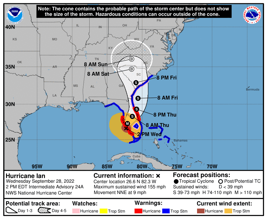
Hurricane Ian made landfall at 3:05 p.m. as a powerful Category 4 storm, with sustained winds of 150 mph. Ian came ashore near Cayo Costa off the coast of Fort Myers, according to the National Hurricane Center. Data from an Air Force Reserve reconnaissance aircraft indicated that Ian's maximum sustained winds were estimated to be near 150 mph, making it a Category 4 hurricane. The latest minimum central pressure estimated from reconnaissance data is 940 millibars.
3:05 p.m. | Hurricane Ian eyewall over Captiva

2:43 p.m. | Power outages update
Lee County Electric Coop reported additional outages across three Southwest Florida counties, according to poweroutage.us:• Collier: 16,000, or about 45%• Lee County: About 110,000 customers, or 60% of the total• Charlotte: 500, or about 65%
12 p.m. | Eyewall moving onshore at Sanibel and Captiva islands
"Eyewall of Ian moving onshore at Sanibel and Captiva islands," the National Hurricane Center said in a noon update. A weatherflow station near Sanibel Island reported sustained winds of 71 mph, just under hurricane strength, with a gust of 98 mph.The noon update said the Ian remains a powerful Category 4 hurricane with winds of 155 mph and is moving at 9 mph.
11:50 a.m. | Lee emergency mangers: Stay inside until storm passes
A message from Lee County emergency managers:
At this time, Lee County Emergency Management is urging Lee County residents to shelter in place immediately.
It is no longer safe to travel on roads.
Based on the current National Hurricane Center forecast, Hurricane Ian is predicted to hit Southwest Florida as a Category 4 or 5 early this afternoon with the potential for 12-16 feet of storm surge above ground level along with destructive waves somewhere along the Southwest Florida coastline from Englewood to Bonita Beach.
The National Hurricane Center anticipates the following here in Lee County:
Catastrophic wind damage is expected beginning in the next few hours.
Structural damage to sturdy buildings, with some complete roof and wall failures.
Heavy rainfall will continue to spread across the county and will intensify, resulting potentially life-threatening flooding.
Large trees snapped or uprooted and many roads impassable from trees and debris.
Destruction of mobile homes and manufactured homes.
Widespread power outages.
Tornados also are possible.
The National Weather Service recommends the following when sheltering in place:
Take refuge in a small interior room, closet, or hallway on the lowest level during the storm.
Put as many walls between you and the outside as you can.
Stay away from windows, skylights, and glass doors.
If the eye of the storm passes over your area, there will be a short period of calm, but at the other side of the eye, the wind speed rapidly increases to hurricane force winds coming from the opposite direction.
Plan to remain inside even after the storm passes so that first responders can ensure conditions are safe.
All responding agencies have stopped responses for the safety of our first responders. You can still call 911.
Calls will be prioritized so that once conditions are safe enough, responses will resume. Response decisions will be made as Hurricane Ian continues to move through the area.
I want to repeat: If you have an emergency or perceived emergency, you should still call 911.
More information is available at www.leegov.com/storm and www.facebook.com/leecountyflbocc.
11:34 a.m. | Lee Health on lockdown
All Lee Health hospitals, as well as Lee Health Coconut Point, are currently on lockdown. That means the entrances have been locked for the safety of our patients and staff within. Lee Health urges community members to shelter in place to avoid injury from dangerous conditions caused by the storm. Lee Health hospitals will reopen after the storm passes and the roads are clear.
We are updating our website regularly and our social media channels with updates. Please visit www.leehealth.org to access the latest information or follow us on Facebook.
Lee Health hospitals are not designated hurricane shelters; only special needs guests who have been pre-registered and designated by the Lee County Emergency Operations Center will be accommodated within hospitals. Others in the community needing to evacuate to shelters and monitor the Lee County Emergency Management website for information about public shelters.
As a reminder, Lee Health hospitals include Lee Memorial Hospital, Cape Coral Hospital, HealthPark Medical Center, Gulf Coast Medical Center, Golisano Children’s Hospital, and The Rehabilitation Hospital.
In the event of power outages, Lee Health hospitals have back-up power supplies to ensure vital care is not interrupted.
10:10 a.m. | Ian now expected to make landfall about 1 p.m.
Forecasters are calling for Hurricane Ian to make landfall in the Punta Gorda area around 1 p.m. this afternoon, but tropical storm conditions will extend into Thursday.
High tide this afternoon at the mouth of the Caloosahatchee River will be at 3:57 p.m., a few hours after Ian is expected to make landfall.
Storm surge is likely to be at its highest around shortly after that as the tide will be incoming while powerful winds blow water up and onshore.
Flooding is expected along the Caloosahatchee River, and there will be upwards of 2 feet of rain in isolated areas.
Winds will be highest in the northwest part of Lee County, according to forecasts.
Windy.com is calling for 90-mile-per-hour winds this afternoon and evening in Southwest Florida.
Tropical storm force wind are possible in Lee County through midnight, according to various forecasting outlets.
The storm is forecast to be northwest of Lake Okeechobee around 2 a.m. Thursday morning.
Ian is expected to emerge into the Atlantic Ocean early Friday morning, according to the latest National Hurricane Center forecast.
10 a.m. | Fort Myers mayor expects 'lots of flooding'
With storm surges of up to a staggering 16 feet expected to Fort Myers, Mayor Kevin Anderson said he predicts “a lot of flooding” from the Caloosahatchee River.
“We're situated right on the Caloosahatchee River and so that will bring a lot of water, a lot of flooding” he told CNN on Wednesday. “There's [also] gonna be some wind damage, loss of power, but I think what's going to be significant is the storm surge.”
8:42 a.m. | Storm surge remains biggest threat for Lee
Forecasters say storm surge is one of the top threats with Hurricane Ian, along with flooding rains and heavy winds.
Surge in the Fort Myers-Cape Coral area is expected to reach upwards of 16 feet above sea level.
That doesn’t mean all of the area will be under 12 to 16 feet of water, just the mostly vulnerable areas along the coast and near rivers.
“There may be locally higher amounts if the storm comes at a certain angle,” said Rick Davis, a meteorologist with the National Weather Service in Ruskin. “This is life-threatening. That’s why we want people to evacuate.”
The high tide today at the mouth of the Caloosahatchee River will be at 3:57 p.m., followed by an even higher tide at 2:46 a.m. Those periods are when levels of storm surge are most likely to reach that 16-foot mark.
“It’s already too dangerous to travel,” he said. “It is a shelter in place right now.”
7:30 a.m. | Ian's storm surge for Lee County upped to 12-16 feet
According to the National Hurricane Center's 7 a.m. update, Hurricane Ian is now forecast to bring a storm surge of 12 to 16 feet from Engelwood to Bonita Beach.
Hurricane Ian's winds remain at 155 mph. Catastrophic wind damage is expected along the southwestern coast of Florida beginning in the next few hours when the core of Ian makes landfall. Preparations to protect life and property should be urgently rushed to completion.
7:10 a.m. | Lee County issues update on Hurricane Ian
Lee released the following updates on Hurricane Ian Wednesday morning:
If you need to get to a shelter, proceed with caution as conditions worsened overnight, and drivers may encounter debris and squalls.
About 3,800 people have evacuated to Lee County shelters.
Don’t put your trash, recycling or yard waste out today. Lee County has just announced haulers also will not collect on Thursday.
If you have an emergency or perceived emergency, you should still call 911 even if high winds prevent in-person emergency responses.
If you call 911 and it’s an emergency, during the time of high winds, Lee County has chief medical staff to provide medical advice and who will call back callers as needed.
Non-urgent 911 calls will be connected via 911 to Telehealth for assistance.
From Law Enforcement Partners: As weather conditions deteriorate, law enforcement encourages you to stay off roads. High winds, low visibility and potential downed trees and powerlines exist.
From Fire District Partners: All responding agencies have stopped responses due to current weather conditions and for the safety of our first responders. You can still call 911. Calls will be prioritized so that once conditions are safe enough, responses will resume. Response decisions will be made as Hurricane Ian continues to move through the area.
Residents are asked to monitor local media and meteorologists’ reports and to check www.leegov.com/storm for Hurricane Ian updates. Follow @Lee County Government on Facebook, www.facebook.com/leecountyflbocc.
6:35 a.m. | Ian's winds increase to near Category 5 strength
According to the National Hurricane Center, recent data from an NOAA Hurricane Hunter aircraft indicate that Hurricane Ian's maximum sustained winds have increased to near 155 mph.
The storm is located about 80 miles south-southwest of Punta Gorda.
5:50 a.m. | Cape Coral suspends emergency services
Cape Coral announced Wednesday morning that emergency services throughout the city have been suspended, and will resume normal operations after winds fall below 45 miles per hour.
A prioritization list will be made for those who call 9-1-1 during this time and assistance will be provided as soon as it is safe. Residents are advised to continue to shelter in place.
Emergency services Citywide are now suspended, and will resume normal operations after winds are below 45 mph. A prioritization list will be made for those who call 9-1-1 during this time and assistance will be provided as soon as it is safe. At this time, shelter in place. pic.twitter.com/U20kRtaPWF
— City of Cape Coral (@CapeCoral) September 28, 2022
5:10 A.M. | The latest on the track of Hurricane Ian
According to Wednesday's 5 a.m. advisory by the National Hurricane Center, Hurricane Ian's maximum winds have increased to 140 mph, making it a Category 4 storm. It is moving north-northeast near 10 mph. It is located about 125 miles west-southwest of Naples.
Ian is expected to make landfall at about 2 p.m. Wednesday near the Charlotte-Lee County border as a Category 4 storm.
Hurricane-force winds are expected in the hurricane warning area in southwest and west-central Florida beginning Wednesday morning with tropical storm conditions expected overnight. Catastrophic wind damage is expected near the core of Ian when it moves onshore.
The most severe conditions for Lee County are expected to be between about 1 and 4 p.m. Wednesday. There is a tornado watch in effect for Lee County until 5 p.m.
Hurricane-force winds extend outward up to 40 miles from Ian's center and tropical-storm-force winds present up to 175 miles from the storm's core.
Hurricane Ian coverage
Ian's path: See spaghetti models, path and storm activity for Florida
Where is Hurricane Ian right now?See NWS radar showing storm's movement near Naples, Florida
Webcams: See traffic and beach conditions in Fort Myers, Cape Coral as Hurricane Ian nears Florida
Power outages: See Fort Myers, Lee County, power outage map as Hurricane Ian impacts Florida
Helpful hurricane resources and links
Florida Hurricane Guide:Find out everything you need to know about preparing for a hurricane or tropical storm in our resource guide
Get your home ready:Here's how to prepare your home for a hurricane, from well in advance to just before a storm's arrival
Need to prepare for a hurricane?Here's what you should have in a disaster supply kit
Hurricane preparedness list:If a storm is coming, here is what you need to do now
Video:Helpful tips for a hurricane survival kit
Hurricanes, typhoons, and cyclones:What’s an invest and why do they keep saying tropical cyclone?
This article originally appeared on Fort Myers News-Press: Hurricane Ian: Fort Myers Wednesday storm updates

