Tropical Storm Lee, two other systems are roaming the Atlantic. What the forecast says
Tropical Storm Gert and Tropical Depression Katia have dissipated, but three systems — Tropical Storm Lee included — continue to mosey about the Atlantic Ocean on Tuesday evening.
Here’s the latest information from the National Hurricane Center:
Tropical Storm Lee forms
The center of Tropical Storm Lee — formed Tuesday morning — was about 1,315 miles east of the Lesser Antilles packing 45 mph maximum sustained winds, the hurricane center said in its 5 p.m. advisory.
Lee is moving toward the west-northwest near 16 mph, and this motion is expected to continue for the next few days with a slight reduction in forward speed.
“Lee is forecast to be a hurricane within a couple of days and will likely become a major hurricane by Friday,” the hurricane center said.
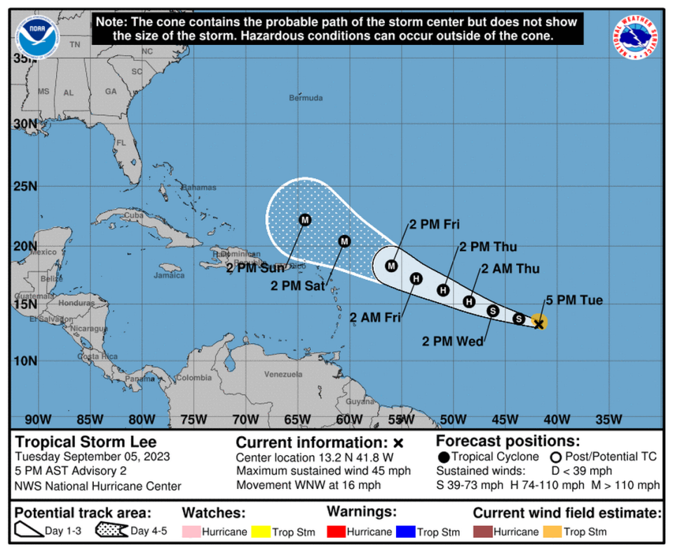
No watches or warnings have been issued but the hurricane center said interests in the Leeward Islands should monitor Lee’s progress.
“No direct impacts to South Florida are expected at this time,” the National Weather Service in Miami said Tuesday night on social media. “This is a good reminder to closely monitor the tropics as we are in the peak of hurricane season.”
9/5/23 7:35 PM: Tropical Storm Lee has formed in the Atlantic. NO direct impacts to South Florida are expected at this time. This is a good reminder to closely monitor the tropics as we are in the peak of hurricane season. #flwx. pic.twitter.com/sJutiG995X
— NWS Miami (@NWSMiami) September 5, 2023
Disturbance off Africa’s coast has medium chance of formation
A disturbance located several hundred miles southeast of the Cabo Verde Islands is producing a large area of showers and thunderstorms, the hurricane center said in its 8 p.m. advisory.
“A tropical depression could form later this week or this weekend while the system moves west-northwestward at 10 to 15 mph over the eastern tropical Atlantic,” the hurricane center said.
Formation chance through 48 hours: 30%, up from 20% at the 2 a.m. advisory.
Formation chance through 7 days: 60%, down from 70% at the 2 p.m. advisory.
Didn’t you used to be Hurricane Franklin?
The remnant of Hurricane Franklin is a few hundred miles northeast of the Azores is producing “limited shower activity,” the hurricane center said in its 8 p.m. advisory. The hurricane center forecasts that the post-tropical cyclone will weaken by late this week.
Formation chance through 48 hours: 10%, up from near zero percent at the 2 p.m. advisory..
Formation chance through 7 days: 10%, down from 20% at the 2 p.m. advisory.

