2-day storm will deliver 2 rounds of snowfall to southeastern South Dakota
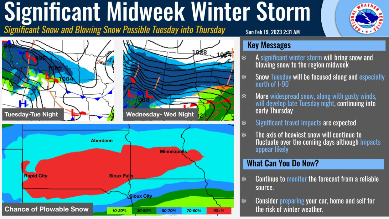
A winter storm watch will be in effect Tuesday through Thursday for southeastern South Dakota, as a significant winter storm expected to bring blizzard conditions moves through the area, according to the National Weather Service of Sioux Falls.
The watch, expected to last from late Tuesday through Thursday morning, states the storm could bring a total of 9 to 16 inches of snowfall to some areas and ice accumulations "of a light glaze" are possible. Winds gusts are expected to reach up to 50 mph, the watch states.
Winter storm watches have been issued for this incoming winter storm.
In some areas, the watch begins Tuesday, but in most areas, the watch begins Wednesday.
Be sure to begin monitoring your local forecast through https://t.co/rqaTwPvE5S or through your favorite media outlet. pic.twitter.com/5QltxLEF4o— NWS Sioux Falls (@NWSSiouxFalls) February 19, 2023
"Travel could be very difficult to impossible. Widespread blowing snow could significantly reduce visibility. The hazardous conditions could impact the morning or evening commute," the alter reads. "Strong winds could cause extensive damage to trees and power lines. The cold wind chills as low as 25 below zero Thursday could cause frostbite on exposed skin in as little as 30 minutes... The greatest risk for blizzard conditions will occur early Wednesday into early Thursday."
What counties are under the watch?
The watch includes southwest Minnesota and east central and southeast South Dakota. As of 5 p.m. Sunday, the watch included the following counties:
Rock
Beadle
Sanborn
Miner
Lake
Moody
Davison
Hanson
McCook
Minnehaha
More:Sioux Falls man tries to 'sell' snow on marketplace amid Tuesday's storm
How much snow could Sioux Falls see?
As of 3:30 p.m. Sunday, there was a high risk the Sioux Falls area could see more than 6 inches of snow through the two-day event, a weather briefing on the NWS website stated. There's also a moderate to high risk the area could see a total of more than 12 inches for the entire storm system, the website states.
How is the storm expected to unfold?
The storm is expected to move through with a one-two punch, with the first round arriving midday Tuesday and lingering through Tuesday night.
That first round will bring at least 2 inches to the sioux Falls area, with heavier snowfall expected north of Interstate 90, the NWS website states.
More:Sioux Falls nearly breaks 1929 snowfall record for January
That second round is where you can likely expect see snowfall of 1-2 inches per hour, as the system brings in a more widespread area of snow Wednesday morning. Then, the storm will intensify by Wednesday afternoon before the whole system moves out by midday Thursday, according to the NWS of Sioux Falls.
Temperatures will also fall dramatically Wednesday night, with wind chill values below zero into Thursday morning.
What does this mean for an already active winter?
"If we start pulling out the record books ahead of a storm, then you know that the potential is there for heavy snow," the NWS of Sioux Falls tweeted Sunday morning.
The most the Sioux Falls area saw for snowfall in a two-day event similar to this one was 31 inches of snow Feb. 17-18 in 1962.
And this storm comes on the heels of a near-record-breaking January. The city very nearly broke its record for January snowfall, with 21.4 inches in 2023, falling just behind the 22.2 inches of snow of 1929, according to a tweet from the National Weather Service.
If we start pulling out the record books ahead of a storm, then you know that the potential is there for heavy snow.
While there is still some uncertainty on the north-south location of the highest snowfall, here are a few 2-day snowfall event records for February. pic.twitter.com/F9hiENSGOf— NWS Sioux Falls (@NWSSiouxFalls) February 19, 2023
What can I do to prepare?
With less than 48 hours to go before the storm arrives, the NWS of Sioux Falls recommended residents:
Review your weather safety plans
Prepare an alternative plan if school or work is closed
Check with family and friends to see if they need assistance
We're still about 48 hours out from the first impacts of a winter storm in the region.
What does this mean to you?
It means you still have plenty of time to become prepared. pic.twitter.com/VhxDbSaYGE— NWS Sioux Falls (@NWSSiouxFalls) February 19, 2023
And if there's between 12-24 hours before the storm arrives, you should:
Charge all portable charges and batteries
Finalize any alternative plans
Pick up last-minute supplies and gas
And finally, if there's less than 12 hours to go before the storm arrives:
Avoid travel if possible
Monitor local media for storm updates
Check on friends and family to see if help is needed
This article originally appeared on Sioux Falls Argus Leader: 2-day storm will deliver 2 rounds of snowfall to southeastern South Dakota

