2 long-track tornadoes confirmed amongst rare December swarm


 |
The National Weather Service (NWS) has given the large tornado that ripped through western Kentucky on Dec. 10 a preliminary damage rating of EF4, with a path length of 165.7 miles and estimated peak winds reaching 190 mph. The tornado's track qualifies it for the top 10 longest tornadoes, according to NOAA Storm Prediction Center data since 1950. It is also the longest tornado on record for the month of December.
The tornado demolished structures throughout the town of Mayfield and other areas in Kentucky faced devastation in its aftermath. Officials say recovery will be a long road ahead for the tornado survivors who are just beginning to pick up the pieces.
Preliminary reports also showed a second long-track tornado to the south which would qualify for the second-longest December tornado path at 122.7 miles, breaking the previous record of 121.7 miles set on Dec. 23, 1956.
The Tri-State Tornado of 1925 has the longest tornado track ever recorded in United States history during any month, spanning a total of 219 miles.
The NWS storm surveys are still in progress for last week's deadly tornado outbreak, which had killed at least 77 in Kentucky, Gov. Andy Beshear said Thursday, bringing the total death toll to at least 91 in five states. If any tornado is confirmed as an EF5, it will break a recent drought of EF5 tornadoes in the U.S. and will be the third EF5 tornado ever recorded in December, preceded by twisters of that magnitude that occurred in 1957 and in 1952.
The U.S. has gone an "unprecedentedly long time between tornadoes rated EF5," Bob Henson writes in a report for Yale Climate Connections. It's been more than eight years since an EF5 tornado touched down on U.S. soil. The previous record gap between EF5 tornadoes was six years from 2001 to 2007. May 20, 2021, marked eight years since Moore, Oklahoma, was ravaged by a deadly EF5 twister.
That last EF5 tornado touched down on the west side of Newcastle, Oklahoma, and became violent in minutes as it tracked east-northeastward across the city of Moore and into southern parts of Oklahoma City.
This was Oklahoma's most deadly and devastating tornado, blamed for claiming 24 lives and injuring scores of people. The tornado was on the ground for about 14 miles and was more than a mile across at its widest.
"The damage was so complete that when rescuers moved in, city officials raced to print new street signs to help guide them through the apocalyptic landscape," according to a report from CNN.
 |
A tornado moves past homes in Moore, Oklahoma, on Monday, May 20, 2013. (AP Photo/Alonzo Adams) |
Unlike the daily temperature or the pressure within a hurricane, tornadoes are rarely recorded by weather instruments near the surface. Surveyors must determine how strong the winds were within a tornado based on the Enhanced Fujita (EF) scale.
Implemented in the U.S. in February of 2007, the EF scale is an update to the original F-scale created by meteorologists and wind engineers to improve the accuracy and precision of damage surveys.
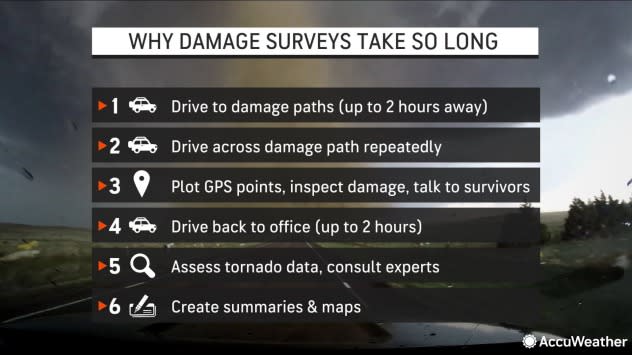
Tornado surveys can take days, weeks or even months to comprehensively conduct and determine precisely where each tornado outbreak ranks. "Trying to determine the strength of the tornado is a lot like forensic meteorology," according to an article posted by the NWS. Meteorologists must piece together clues from the damaged region to determine how strong the winds were that caused it -- and whether those winds were rotating in a tornado or were straight-line winds.
 |
Assessing the extent of the damage and structural integrity of an object and interacting with people affected by the tornado are critical components of the damage survey, which all take time. Depending on the length of the tornado track, multiple NWS offices may be involved, which will extend the time it takes to collect and analyze all of the data.
Over the past 30 years, the technology used to conduct a damage survey has changed considerably, making the survey process more accurate.
"I remember years ago using maps, pencil, pens, and an odometer as a guide," Brian Smith, a warning coordination meteorologist at NWS Omaha shared.
Surveyors can now upload information, rate the damage using the EF scale and share photos of the damage with their fingertips on a smartphone or tablet with the Damage Assessment Toolkit (DAT). Aerial surveys are used to get a scope of the damage track from above, while high-resolution satellite imagery can be used to determine the exact track of the tornado by looking at vegetation scars.
Documenting tornado ratings has improved the understanding of tornadoes, leading to improved severe weather forecasts.
For the latest weather news check back on AccuWeather.com. Watch the AccuWeather Network on DIRECTV, Frontier, Spectrum, fuboTV, Philo, and Verizon Fios. AccuWeather Now is now available on your preferred streaming platform.
