Several tornadoes reported as dangerous storms fire up, threatening 20 million from Texas to the Southeast
Dangerous thunderstorms rumbled to life across parts of the South on Monday as more than 20 million people from eastern Texas to the Southeast faced a threat of damaging winds, hail and potentially strong tornadoes.
The severe thunderstorms moved across eastern Texas and the Mississippi Valley, bringing at least six reports of high winds, including gusts in Copiah County, Mississippi, estimated at more than 60 mph.
“A storm system will move from the southern Plains to the Northeast U.S. through Wednesday with severe thunderstorms for the northern Gulf states, gusty winds and heavy rain for the Southeast, and a wintry mix for the interior Northeast,” the National Weather Service said.
Tornado watches were in effect Monday night for more than 2.5 million people – mostly in Mississippi – as dangerous storms sprung to life. There were four reports of tornadoes in the state as of 8:15 p.m. CT, following one reported twister earlier in neighboring Louisiana.
An enhanced risk level for severe storms, or a Level 3 of 5, was in effect Monday night for parts of eastern Louisiana and central Mississippi, including Hattiesburg, Mississippi, the Storm Prediction Center said. The greatest risk for strong tornadoes that could deliver wind speeds over 111 mph – EF2-strength or stronger – remained possible across portions of the lower Mississippi Valley, the center said.
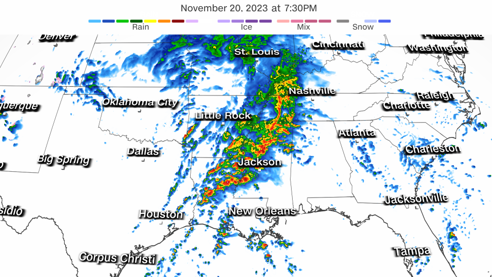
Level 1 and 2 severe threats were in place from Texas to Alabama and Arkansas, including Houston and Little Rock, Arkansas.
Tornado warnings hadn’t been issued across much of the Southeast since late June, but that changed Monday afternoon. November marks the start of a secondary severe weather season in the region. The clash of cold, Canadian air drilling into the South and lingering warm, moist air over the Gulf of Mexico typically leads to an uptick in damaging thunderstorms from November to December.
The storms may bring a brief reprieve to drought-stricken Louisiana and Mississippi, which could see excessive rainfall of up to 2 inches on Monday, and as many as 3 inches in some areas, according to the Weather Prediction Center.
Louisiana is suffering through its worst drought on record – one that’s fed unprecedented wildfires and contributed to the potentially catastrophic intrusion of saltwater into the Mississippi River. Exceptional drought – the US Drought Monitor’s most extreme category – now covers nearly three-quarters of the state, according to data released last week. In neighboring Mississippi, exceptional drought has spread over more than half of the state.
West waves goodbye to heavy snow
The same storm delivering severe thunderstorms to the South blew through the Rockies over the weekend, leaving heavy mountain snowfall piled nearly a foot high in several parts of Utah, Nevada and Colorado, preliminary snow reports show.
Parts of Utah saw a foot or more of snow, followed closely by some cities in Nevada.
Here are some of the latest preliminary snowfall totals reported by the National Weather Service:
Alta and Collins, Utah, area: 13 inches
Snowbird, Utah: 12 inches
Pole Canyon, Nevada: 11 inches
Green Mountain, Nevada: 11 inches
Mt. Rose Ski Base, Nevada: 10 inches
Mount Crested Butte, Colorado: 7 inches
Mammoth Mountain Ski Base, California: 7 inches
Lower elevations were still warm enough to receive rainfall, with storm totals of 1 to 3 inches reported and isolated totals exceeding 3 inches.
High wind gusts also swept the region, with a gust of 144 mph reported in Mammoth, California, which has an elevation of nearly 10,000 feet.
For more CNN news and newsletters create an account at CNN.com

