Storms, strong wind gusts may cut power for New Year's Eve celebrations in Tennessee, Ohio Valleys
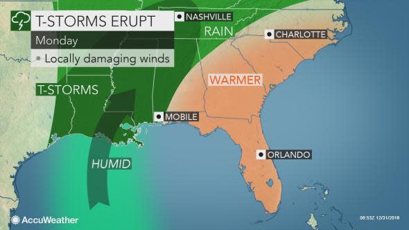
The same storm producing drenching rain and pumping warm air into the eastern United States will bring gusty thunderstorms and the potential for damaging winds over the Tennessee Valley into Monday night.
Winds will generally be blowing from the same direction near the ground and at the jet stream level of the atmosphere.
When this setup occurs, the strong winds from aloft are able to make their way down to the ground.
Both thunderstorms and showers can deliver the powerful gusts, according to AccuWeather Lead Storm Warning Meteorologist Eddie Walker.
"Thunder and lightning will not be necessary for a damaging wind gust to occur," Walker said.
Windy conditions are in store from Louisiana to the Florida Panhandle, northward to Kentucky.
The greatest potential for a gust strong enough to knock down trees, cause power outages and property damage will be during or in the vicinity of showers and thunderstorms.
As of the early afternoon hours on Monday, the storm system has had a history of damaging winds and causing power outages in portions of western Kentucky and central Mississippi. In Tennessee, Kentucky, Mississippi and Alabama combined, there were 45,000 utility customers without electricity, according to poweroutage.us.
"There is not a lot of support for the atmosphere to produce tornadoes in this situation, despite the strong winds in general," Walker said.
However, there is always a small chance for a severe thunderstorm to spin off a tornado.
Motorists venturing along the interstates 20, 40 and 64 will face the strongest crosswinds. Gusts may become strong enough to push lightweight vehicles off the road and flip over high-profile vehicles, such as trucks and campers.
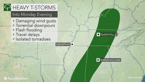
Along with the risk of damaging wind gusts will be brief, torrential downpours accompanying the showers and thunderstorms.
Download the free AccuWeather app to get the latest forecast and any severe weather advisories for your location.
Since the large storm is making for conditions similar to the spring or summer, any downpour has the potential to cause flash and urban flooding.
The risk of damaging winds and flooding downpours will diminish over the Tennessee Valley from west to east as drier air takes hold later Monday night.
However, a quick burst of strong winds may knock down trees and cause power outages from northeastern Ohio to western New York state, western Pennsylvania and West Virginia during the middle of Monday night.
A few locally heavy and gusty showers and thunderstorms may be found in the Southeast states on New Year's Day.
The amount of drying will be limited, however.
Showers may linger along the central Gulf coast on Tuesday to Wednesday. A new storm is forecast to spread rain northward across the Tennessee Valley from Thursday to Friday.
2018 was a record-breaking year for extreme weather events and storms. Extreme Meteorologist and Storm Chaser Reed Timmer talked to us about his top five chases of the year. He discussed some of his most dangerous experiences, what it's like to be out in the field and the moments he'll never forget.
