2022 Hurricane season: What are the hurricane categories and what do they mean?
After a quiet start to the 2022 hurricane season, action in the tropics is picking up steam. But what are the hurricane categories and what do they mean? Here is a break down of storm categories and how they may affect an area according to the National Hurricane Center.
How are hurricanes measured?
It all starts with the Saffir-Simpson Hurricane Wind Scale.
This is a wind scale from 1 to 5 that is based on the maximum sustained wind speed measured within a hurricane. No other factors, such as storm surge, flooding or tornadoes, are taken into account. The Saffir-Simpson Hurricane Wind Scale only measures wind speed.
With the Saffir-Simpson Hurricane Wind Scale, it is possible to estimate potential property damage that can be caused by a hurricane. However, weather experts note that all hurricanes are capable of producing life-threatening winds regardless of their category classification.
Category 1 hurricane: 74-95 mph wind
A storm becomes a Category 1 hurricane when its sustained winds reach 74 mph. That's the same strength as an EF1 tornado and it's going to cause damage to your home even if it's made of brick. Those high-speed, intense winds, are exactly why weather experts advise people in mobile homes to evacuate in a Category 1 storm. Although anchors can help keep a mobile home from twisting and lifting in a storm there is nothing to keep strong winds from damaging the walls or roof of a mobile home.
As in all hurricanes, power outages are likely in a Category 1 storm as trees snap and power lines fall victim to the winds. It could be days or weeks before the power is restored after a Category 1 hurricane.
Elsa was the first named hurricane of the 2021 Atlantic storm season. It was the earliest 'E' named storm on record. The storm was downgraded to a tropical storm before making landfall.
You don't eat it, you follow it: Hurricane spaghetti models: Things you need to know to track the models
Category 2 hurricane: 96-110 mph wind
Once the sustained winds in a hurricane reach 96 miles-per-hour, it becomes a Category 2 hurricane. In a Category 2, winds can be as high as 110 mph and cause extensive damage to homes and businesses. Experts say even a well-constructed home could suffer major damage in a Category 2 hurricane. Trees and power lines will fall as the most powerful winds of the hurricane move through taking out the power. Experts say near-total power loss can be expected with a Category 2 hurricane and some outages could last from several days to weeks.
For example, in September 2020, Hurricane Sally began as an ambitious twirl of thunderstorms between the Bahamas and South Florida that National Hurricane Center forecasters labeled Tropical Depression 19. On September 12, 2020, it entered the Gulf of Mexico, just off of Everglades City, becoming a tropical storm, ultimately growing into a devastating Category 2 hurricane, making landfall near Gulf Shores, Alabama.
Sally wasn't even considered a tropical storm until 10 a.m. Sept. 12 when it entered the Gulf of Mexico, just off Everglades City.
When it's time to go: When should I evacuate for a hurricane? No matter your plan, make an early decision
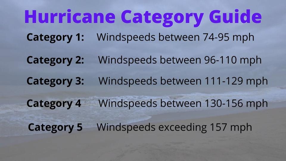
Category 3 hurricane: 111-129 mph winds (major hurricane)
Once a hurricane becomes a Category 3 it is now classified as a major hurricane. In fact, all hurricanes from Category 3 to 5 are known as major hurricanes. Sustained winds in a Category 3 storm have reached 111 mphand can be as strong as 129 miles-per-hour. An example of a Category 3 storm is Hurricane Delta in 2020.
Delta was the 25th named Atlantic storm of that season. It strengthened to a Category 3 storm with sustained winds at 120 mph and then slowed down to a Category 2 before making landfall in Louisiana in October 2020. Homes and businesses were destroyed and power was not restored to the area for weeks. This is typical of a Category 3 hurricane as the wind speed is equal to that of a EF2 tornado. Weather experts say most of the area in the Category 3 hurricane will be uninhabitable for a long period of time.
In 2020, Louisiana was hit by three hurricanes. Hurricanes Laura, Delta and Zeta all struck the region causing massive damage with each storm. The region was devastated for months afterward.
Category 4 hurricane: 130-156 mph winds (major hurricane)
Also a major hurricanes, a Category 4 will cause catastrophic damage as it makes landfall and moves across land. With winds sustained at a minimum 130 mph and a maximum of 156 mph, the devastation can be quite severe. Hurricane Laura in 2020 is an example of a Category 4 hurricane. Experts with the National Hurricane Center note that even a well-built, framed, home can expect major damage from a Category 4 hurricane.
Power outages are almost guaranteed as trees break and fall onto power lines in a Category 4 hurricane. You can expect long power outages in this type of hurricane which can isolate areas from getting to, and receiving help. A large percentage of the area affected by a Category 4 hurricane will be uninhabitable for several weeks or even months after the storm strikes.
In August 2020, Hurricane Laura made landfall on the border of Texas and Louisiana with sustained winds of 150 mph. Half a million people were left without power as the storm ripped through, leaving utter devastation in it's wake.
Why are we getting hurricanes in the fall?: Scary trend: Major hurricanes in October and November - why is it happening?
Category 5 hurricane: 157 mph+ winds (major hurricane)
Although rare, a Category 5 hurricane does occur. Hurricane Andrew, which devastated southern Florida in August 1992, struck with the force of Category 5 winds and storm surge even though it was only a Category 4 storm as it made landfall. The devastation from a Category 5 hurricane is nothing short of catastrophic.
Weather experts say most, if not all, framed homes are destroyed in this type of hurricane. Power failure results in widespread outages that leaves cities and towns without access to food, water or transportation for days and weeks. A Category 5 storm will leave an area nearly uninhabitable for an extended period of time.
Hurricane Iota reached Category 5 status in 2020. The storm formed in November of that year and had maximum sustained winds of 160 mph. It was the 13th named storm of an extremely active Atlantic hurricane season.
2020 broke records
The 2020 hurricane season had an unprecedented 30 named storms, including 13 hurricanes. Of the 13 hurricanes, six were major storms of Category 3 or higher. Normally a hurricane season has 12 named storms, including six hurricanes, of which three are major hurricanes. In 2020, the season was so active that the designated names were exhausted and succeeding storms that season were named by the greek alphabet.
A total of twelve storms made U.S. landfalls in 2020 - tropical storms Bertha, Cristobal, Fay, and Beta, and hurricanes Hanna, Isaias, Laura, Marco, Sally, Delta, Zeta and Eta.
Storm surge
Prior to and during a hurricane, forecasters warn about storm surge. Although the winds of a hurricane cause unsurmountable damage, it is storm surge that is the greatest threat to life.
As a hurricane approaches, ocean water is pushed toward the shore by the force of the winds swirling around the storm. It is that advancing water, combined with tidal surge, that can raise water levels by as much as 30 feet.
Storm surge can move fast, causing extensive damage to homes and businesses. It causes catastrophic erosion to beaches and can take out roads, buildings, anything in its path.
As the water moves inland it swells rivers and streams causing a flash flood emergency. Storm surge with hurricanes cannot be prevented but there is an early warning system in place to protect you.
The Sea, Lake and Overland Surges from Hurricanes (SLOSH) was developed by the National Weather Service to estimate storm surge heights. Storm surge and hurricane watches and warnings should be taken seriously to protect and preserve life.
Hurricane Evacuation
Modern technology has made it possible to know well in advance of the strength and likely path of a hurricane. Having a hurricane evacuation plan is essential. Residents in hurricane prone areas and in coastal regions should know their evacuation zone, routes and maps. Make a plan for your family and a plan for your pets ahead of a hurricane when an evacuation is issued and remember to take your disaster supply kit with you when you leave.
Keep in mind that no place in Florida is safe from a storm. A hurricane can envelop much of the state or march up the coast and turn to where you decided to evacuate to. In 1995, Erin threatened Miami, and thousands fled to Orlando, where Erin struck.
This article originally appeared on Palm Beach Post: Hurricane categories: How storm strength and wind speed are measured

