2023 hurricane season will be 'once-in-a-generation slugfest' between tropical forces
Here comes the story of the hurricane season: a once-in-a-generation slugfest between twin titans of the Tropics. Live. Six months only. In your backyard, potentially.
In one corner, the Unstoppable Force of an incipient El Niño, maker of coulda-beens out of contender hurricane seasons. In the other, the Immovable Object that is the scorching Tropical Atlantic, packing an explosive thermodynamic punch.
These two atmospheric heavyweights have never been more diametrically opposed entering a hurricane season than in 2023, making for an uncertain seasonal outlook. Fortunately, we have a system: an eye of the Tiger, if you will. WeatherTiger’s seasonal models not only offer specific odds of overall activity and U.S. landfall risks in this pre-season outlook, but will continuously update those probabilities each day between now and October as punishing blows are exchanged.
More on that later, but first, a little about your humble ringside correspondent: I’m Ryan Truchelut, Chief Meteorologist at WeatherTiger, a weather analytics and forensic meteorology firm. I have a doctorate from Florida State, almost 20 years of professional hurricane forecasting and research experience, and seven years of providing analysis and dad humor for the USA Today Network - Florida group.
Expect a column each Monday, with more frequent forecasts as the situation warrants. Also, note that I’m an avid runner with zero boxing knowledge, though if I had the opportunity to name a subdivision street, I would call it Judgemills Lane.
Take that, Hawaii! This Florida beach tops Dr. Beach's Top 10 list for 2023
More from WeatherTiger: Florida hurricane season has a 70% shot at normalcy, but it only takes one
More: House plan to overhaul Florida tourism revenue not welcome by industry, counties
Without further ado, let’s get ready to rumble. Meteorologically speaking.
Here are the contenders:
El Niño
Nicknames: Pacific Pugilist, Shear Annihilation, The Southern Oscillation Dandy, The Mandatory Farley Reference
Vitals: El Niño is the warmer half of a climate cycle known as the El Niño-Southern Oscillation (ENSO). Key Niño features includes sea surface temperatures (SSTs) in the Central Equatorial Pacific of more than 0.5°C above normal, and an interlocking regime of weaker trade winds and increased convection in the same area. Once this feedback cycle begins, El Niños usually persist for around a year.
ENSO matters for Atlantic hurricane seasons because a rollicking El Niño causes persistent wind shear, or strength and direction changes with height, especially in the Caribbean and southern Gulf of Mexico. Wind shear exceeding about 30 knots is highly unfavorable for hurricane development, capable of chumping even the most formidable tropical waves.
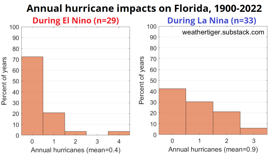
The Record: El Niño is the single strongest pre-season predictor of U.S. landfall activity. About one-quarter of hurricane seasons occur during Niños; in these years, there is only a 65% chance of at least one continental U.S. hurricane landfall, and a little less than a 30% chance of a major hurricane landfall. That is significantly less than the 90%+ chance of one or more U.S. hurricane landfalls and 65% chance of a major hurricane landfall during La Niñas.
This relationship holds true in Florida as well, with odds of at least one Florida hurricane plunging from nearly 60% to around 25% moving from La Niña to El Niño conditions.
Weigh-in: El Niño is a hungry young fighter as the 2023 hurricane season approaches. While SST anomalies in the Central Pacific are just now crossing the +0.5°C ENSO threshold, ocean temperatures in the Eastern Pacific that often prefigure Niño strength are already the third-warmest since 1950. This year’s SSTs in the east trail only the monster El Niños of 1983 and 1997.
The rapid transition out of last winter’s La Niña, impressive subsurface warmth, and a strong model consensus all indicate that the 2023 El Niño is most likely to see SST anomalies between +1.0 and +1.5°C during the peak of hurricane season— setting up a potential haymaker to storms transiting the southern Gulf or Caribbean. Yet as much as we’d like to, we can’t throw in the towel on the 2023 season. A challenger arises.
The Atlantic Multidecadal Oscillation
Nicknames: The Sargassum Scalder, Ruinous "Hurricane" Starter, The Property Insurance Crisis Kid
Vitals: The Atlantic Multidecadal Oscillation, or AMO, is a purported natural cycle in which Tropical Atlantic SSTs alternate between 20 to 50 year colder and warmer periods (future column alert for an AMO Eras tour). During warm AMO phases, like the one that began in 1995, SSTs are generally above normal in the Main Development Region of the Tropical Atlantic and a crescent of the eastern Atlantic extending north to Iceland.
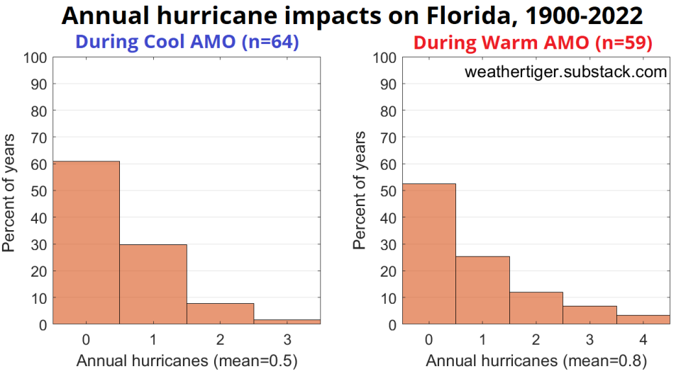
The Record: The AMO doesn’t have quite the dominance of ENSO, as on shorter terms Atlantic warmth can ebb and flow in a way that a mature El Niño does not. However, warm AMO regimes still have considerably higher hurricane risks in both the continental U.S. and Florida. The average number of annual U.S. hurricane impacts is about 35% higher during a warm AMO than a cool AMO, and around 60% higher in Florida.
Weigh-in: Warm AMO is flying high now. In fact, SSTs in the linchpin regions of the eastern Atlantic are nearly half a degree warmer than previous records and rising. These warm SST anomalies also closely conform to the regions where May ocean temperatures have the strongest historical relationship with busy hurricane seasons. In the absence of an onrushing El Niño, this pattern and its extreme amplitude would be extraordinarily alarming. As is, it merely sets up ENSO vs. AMO: Tropic Thunder.
Laying odds
Every seasonal forecaster has a plan until they get punched in the mouth. This year’s punch is that the two most reliable pre-season predictors are more divergent than they ever have been.
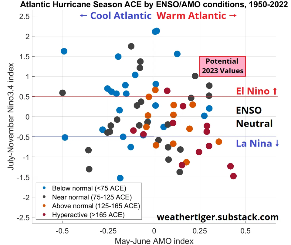
Above average or hyperactive hurricane seasons occur when neutral or warm AMO and neutral or La Niña ENSO conditions are occurring simultaneously. With ENSO and AMO semi-independent of one another, they are very seldom in-phase. Since 1950, there are only three other seasons with the May-June AMO index exceeding +0.2 and an active El Niño. The 2023 AMO and ENSO values are quite likely to be warmer than these loose analogs (1951, 1953, and 2006), all of which were near normal seasons. With expected values of ENSO and AMO in the “here be dragons” region of the map, analog-based forecasting methods are of limited value for the upcoming season. There simply are not solid historical parallels to 2023.
Fortunately, WeatherTiger’s seasonal models have been hitting the stadium steps and slamming raw eggs in the off-season, preparing for just such a prizefight. Our upgraded model for 2023 considers a broader and more optimized array of predictors than before, capturing not only how the Atlantic and Pacific are currently, but how they might evolve into the peak of the season.
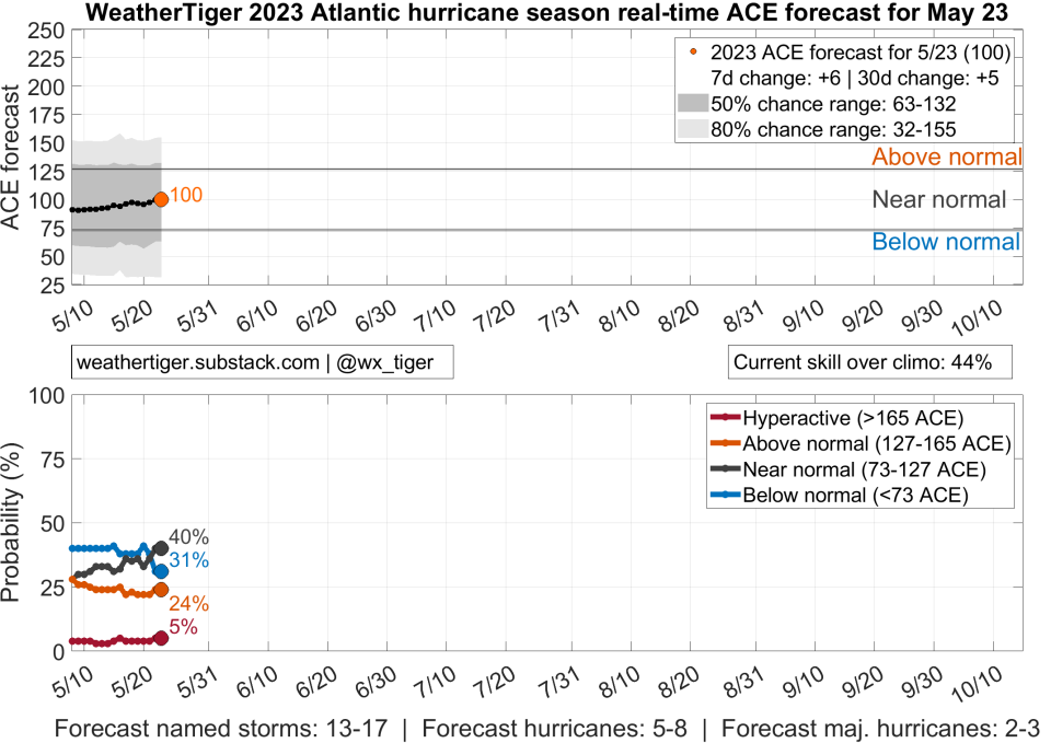
With ENSO and AMO in an even more liminal state than Florida itself, our model’s true power this year is its unique real-time capability. Each day between now and October, WeatherTiger’s algorithm will digest an updated snapshot of the ocean and atmosphere, and intelligently translate that tsunami of raw data into fresh odds of how Hurricane Season 2023 might play out. Check out updated daily predictions at weathertiger.com. [ACE line plot]
Will 2023 float like a butterfly or sting like a bee? It might do a little of both, with ENSO and AMO most likely fighting to a draw. The odds of a below normal, near normal, above normal, and hyperactive hurricane season, respectively, are about 30%, 40%, 25%, and 5%. Notably, though there is still a significant chance of above average activity, WeatherTiger’s model is bearish on the potential for a hyperactive season, which would be tough to accomplish with the Caribbean and southern Gulf taking a dive.
Still, unfavorable conditions there don’t preclude U.S. landfalls. This year, WeatherTiger is debuting a seasonal model tuned to predict the net tropical activity occurring near or over the continental U.S. This model is also calling for landfall risks close to long-term averages, with around a 45% chance of U.S. tropical activity coming in close to normal. That translates into a 25% chance of three or more hurricane impacts, a little over a 50% chance of 1 or 2 impacts, and a 20% chance that the continental U.S. escapes 2023 without a hurricane encounter.
This model suggests a 40% chance of at least one major hurricane impacting the continental U.S., which is higher than the baseline 30% chance during an El Niño. Our U.S. landfall risk model is running in real-time starting today and can also be found on our website.
Ringing the bell
As the Atlantic and Pacific heat up like the bun-warming lid of a George Foreman Grill, the purported normalcy of the 2023 Hurricane Season may well be the average of long stretches of boredom punctuated by moments of terror. Qualitatively, I think it is quite likely that a top 10 El Niño is forming, which is going to put a kibosh on Caribbean activity no matter how warm the water is there. That may mean a busier first half of hurricane season and a quieter October.
On the other hand, extreme warmth in the eastern and subtropical Atlantic, where the reach of ENSO is weaker, augurs a busier year than is typical of El Niños. WeatherTiger’s daily model output is drifting in a bit more active direction as the season approaches, perhaps recognizing an incoming split decision.
As a final caveat, “near normal” hurricane seasons contain the multitudes. Last year ended close to historical averages for overall activity, yet landed a $113 billion knockout punch. As vast swaths of the Gulf Coast carry the reminders of every glove that laid us down, remember that the only way to be hit and hit back, a.k.a. the name of the game, is to make a hurricane plan before storms threaten. In the meantime, here’s hoping for a respite from needing to activate those plans in the season ahead. Keep watching the skies.
Dr. Ryan Truchelut is chief meteorologist at WeatherTiger, a Tallahassee company providing forensic meteorology and expert witness services, and agricultural and hurricane forecasting subscriptions. Visit weathertiger.com to read an expanded version of this outlook and discover how to put our expertise to work for you.
This article originally appeared on Tallahassee Democrat: 2023 hurricane season: Tropical forces El Niño and AMO to battle

