3 dead in Southeast storms as Florida governor issues state of emergency
- Oops!Something went wrong.Please try again later.
Jan. 9 (UPI) -- Three people were killed Tuesday in severe weather, which has hit much of the Southeastern United States, as Florida Gov. Ron DeSantis declared a state of emergency following a string of tornadoes that caused widespread damage.
Forecasters warn there is more to come, with tornado watches currently in effect from Florida to Virginia.
DeSantis, who declared the state of emergency for 49 of Florida's 67 counties, activated the Florida State Guard on Monday. The storms, which hit early Tuesday morning, damaged buildings, downed trees and left thousands without power across a number of states.
An 81-year-old woman died in Alabama and several buildings were destroyed after a reported tornado hit Cottonwood. A man was killed in North Georgia after a massive tree fell onto his car in Clayton County, according to police, where strong winds and heavy rain have caused widespread flooding and power outages. A third person was reported killed in Claremont, N.C., after a strong wind storm damaged homes in a mobile home park. The National Weather Service is still evaluating whether that storm was a tornado.
While there have been no deaths reported in Florida, several people were injured in Marianna.
"First look at tornado damage in Marianna, Florida early Tuesday morning. Buildings were torn apart and mobile homes were tipped over," Accuweather wrote in a post on X, showing the damage.
First look at tornado damage in Marianna, Florida early Tuesday morning. Buildings were torn apart and mobile homes were tipped over.
The Gulf Coast continues to see tornado threats throughout the morning. pic.twitter.com/yuFOiM8aIt— AccuWeather (@accuweather) January 9, 2024
Tuesday's storm, which first pounded the Midwest with blizzard conditions, brought heavy rain, powerful winds and tornadoes across much of the South.
The National Weather Service confirmed at least three tornadoes across the Florida Panhandle, where wind gusts hit 106 mph, toppling trees and knocking out power to thousands.
"Electric crews are continuing to work as swiftly and safely as possible to restore power," the City of Tallahassee wrote in a post on social media Tuesday.
Electric crews are continuing to work as swiftly and safely as possible to restore power across the City with recent restorations near Roberts Avenue, Jackson Bluff Road, Miccosukee Road, Cherry Laurel Street, Bannerman Road, Lantern Light Road, Teal Lane and Surgeons Drive. pic.twitter.com/ASVQ23C1uJ— City of Tallahassee (@CityofTLH) January 9, 2024
A number of schools and government buildings throughout the Southeast shut-down as others planned early dismissals. Airports across the Midwest and Southeast also reported flight delays and cancelations in advance of more severe weather in the forecast.
"A line of severe thunderstorms with embedded tornadoes continues to push east across the southeastern United States as of 2 p.m. EST today. If you're in a tornado warning, TAKE COVER NOW!" the National Weather Service warned in a post on X on Tuesday afternoon. "Move to an interior room on the lowest floor of a sturdy building. Avoid windows."
A line of severe thunderstorms with embedded tornadoes continues to push east across the southeastern US as of 2pm EST today. If you're in a tornado warning, TAKE COVER NOW! Move to an interior room on the lowest floor of a sturdy building. Avoid windows. pic.twitter.com/kNLH1AcvSQ— National Weather Service (@NWS) January 9, 2024
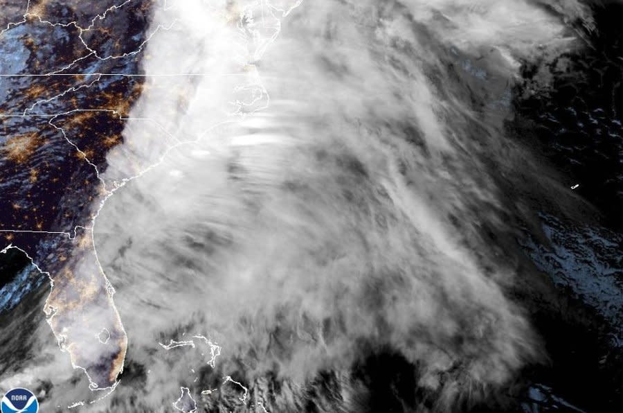
Forecasters and the Storm Prediction Center warn the strong low pressure system will continue to move across the eastern United States and bring severe weather to parts of Florida and much of the Southeast through Tuesday.
There is an enhanced risk for severe thunderstorms across North Florida and a slight risk for severe weather across Central Florida. Forecasters warn of damaging wind gusts over 70 mph, large hail and flash flooding. Tornado watches, which stretch north along the Southeast into Virginia, are also in effect for much of the Florida Panhandle and Big Ben through Tuesday.
"Because of the foregoing conditions, which are expected to constitute a major disaster, I declare that a state of emergency exists," DeSantis wrote in his executive order, which will allow Florida to reallocate resources and coordinate emergency agencies quicker as more severe weather moves in from the west.
The Florida counties listed in the state of emergency are Alachua, Baker, Bay, Bradford, Brevard, Calhoun, Citrus, Clay, Columbia, Dixie, Duval, Escambia, Flagler, Franklin, Gadsden, Gilchrist, Gulf, Hamilton, Hernando, Hillsborough, Holmes, Jackson, Jefferson, Lafayette, Lake, Leon, Levy, Liberty, Madison, Marion, Nassau, Okaloosa, Orange, Osceola, Pasco, Pinellas, Polk, Putnam, Santa Rosa, Seminole, Sumter, St. Johns, Suwannee, Taylor, Union, Volusia, Wakulla, Walton and Washington.
As the storms move across the South on Tuesday, blizzard conditions are heading to the Northeast.
The Northeast is also bracing for heavy rainfall, between 1 and 3 inches by Tuesday night, after a major snowstorm dumped as much as 22 inches across New England over the weekend.
"Heavy rainfall will bring widespread and potentially significant river and flash flooding to the Eastern United States on Tuesday. Severe thunderstorms are possible across portions of the Southeast on Tuesday. Heavy snow will continue across portions of the Midwest and in the Cascades," the National Weather Service wrote Monday night in a post on X.
Heavy rainfall will bring widespread and potentially significant river and flash flooding to the Eastern U.S Tuesday. Severe thunderstorms are possible across portions of the Southeast Tuesday. Heavy snow will continue across portions of the Midwest and in the Cascades. pic.twitter.com/CvgU6FXI76— National Weather Service (@NWS) January 9, 2024
Meteorologists with the National Weather System on Tuesday blamed this week's severe weather on an "historically strong" El Niño.
"This is a classic El Niño pattern with the subtropical jet generating a lot of high clouds," said NWS meteorologist Nick Carr. "The storm pattern is also progressive. You have a system, then two or three days, you get another system. It's a steady stream."

