3 tornadoes that struck Ocean and Monmouth counties were all EF-2s
Six tornadoes struck New Jersey on Saturday, including three that touched down in Jackson, Howell and Sea Girt, which were classified as EF-2 by the National Weather Service in Mount Holly — with the most powerful one in Jackson, with peak winds of 130 mph.
A fourth tornado that touched down in Allentown and the Cream Ridge section of Upper Freehold Township was rated as an EF-1, with a top speed of 90 mph.
In addition to the ones in Jackson, Howell, Sea Girt and Allenwood-Upper Freehold, there were confirmed EF-1 tornadoes in Cinnaminson and Chesterfield in Burlington County. The weather service is also investigating a possible tornado in the Mays Landing section of Hamilton in Atlantic County.
The Enhanced Fujita scale — updated in 2007 — rates the power of a tornado on six levels, with an EF-0 classified as a tornado with 65 to 85 mph wind gusts and an EF-5 is classified as a tornado with wind gusts of more than 200 mph. An EF-2 is a tornado with wind gusts of between 111 to 135 mph; an EF-1 has wind gusts of 86 to 110 mph.
The number of tornadoes that touched down in New Jersey on Saturday was unusually high for a single day and for the month of April in the Garden State, according to state climatologist David Robinson at Rutgers University.
Since 1950, there had only been six tornadoes recorded in New Jersey in the month of April. After this weekend, that number had doubled to 12, according to state climatology records.
Over the course of a single year, New Jersey has experienced as many as 19 tornadoes — that was in 1989; and there were 13 tornadoes in 2021, Robinson said.
Saturday's events were precipitated by a powerful line of thunderstorms that moved from west to east across the state, according to the National Weather Service’s Mount Holly office.
Jackson tornado
The tornado in Jackson formed out of an eastward moving rotating "supercell" that made its initial touchdown near Patterson road, off of West Commodore Boulevard near the Carl W. Goetz Middle School, according to the weather service.
The twister would travel for 2.1 miles after it was first detected at 7:24 p.m. Saturday. The tornado moved east on what the weather service described as a ¾-mile long and 200-yard wide path through the neighborhood on the north side of Stonehenge Court and West Commodore Boulevard, before going across Wright Debow and Hamilton roads.
Utility poles were knocked down or snapped under the force of the winds. Yard fences were demolished; sheds, other outbuildings and dumpsters flipped over or were moved. Dozens of large hardwood and softwood trees were snapped or uprooted in the convergent pattern. Despite the significant tree damage, the damage to property here was comparably limited and consistent with winds of 90 to 110 mph, the weather service said in its report of the event.
Related: 'Like a freight train': Jackson residents describe tornado that damaged town
The tornado then likely strengthened to its greatest intensity as it continued east, across a cleared and paved area, to a newly-built large warehouse development. The southern half of the complex, comprised of several three-story, concrete pre-fabricated tilt-up walls tied together with a metal roofing system above, collapsed in an eastward direction, according to the report.
Based on the degree of damage, the weather service estimates that the tornado had reached EF-2 strength with 120 to 130 mph winds. Dozens of trees on the south and southeast side of the complex and its east parking lot were uprooted or their trunks simply snapped, having fallen to the east and northeast.
The tornado then moved on in an east-southeast direction for another ¾ of a mile, just north of the self-styled old-fashioned gas station called GasTime on West Commodore Boulevard, across Diamond Road and then back along West Commodore; and into the residential neighborhood around Indiero Road and Oak Tree Lane where there was minor siding and roof damage later reported, the weather service said.
Extensive tree and powerline damage resulted along West Commodore Boulevard, with hundreds of trees againuprooted or cut down, numerous utility poles taken out, with the tornado littering its path with roof and insulation debris from the warehouse complex. Here, the tree damage along West Commodore Boulevard was consistent with winds of 100 to 120 mph. The weather service believes the tornado weakened to an EF-0 as it struck the homes around Indiero Road and Oak Tree Lane, with the tree damage path becoming scattered and narrowing to 100 yards, The tornado event ended at 7:27 p.m. at the Land O Pines Mobile Home Park on West Commodore Boulevard, all according to its assessment of the storm.
Earlier: Tornadoes touch down in Jackson, Howell, Sea Girt, Weather Service confirms
Jackson-Howell tornado
The second EF-2 tornado to form over Jackson happened at 7:33 p.m. at the intersection of Larsen Road and Maplewood Place. This tornado would travel into Howell, covering 1.4 miles and lasting for only about one minute in total duration, according to the weather service.
As with the first EF-2, trees were snapped or uprooted, and power poles were downed, on either side of Larsen Road. The tornado tracked east-southeast across the homes on the east side of Maplewood Place and the northeast section of Dogwood Drive, with about a 150-yard width path of downed utility poles, trees, shattered fences, and flipped or moved sheds, the report said.
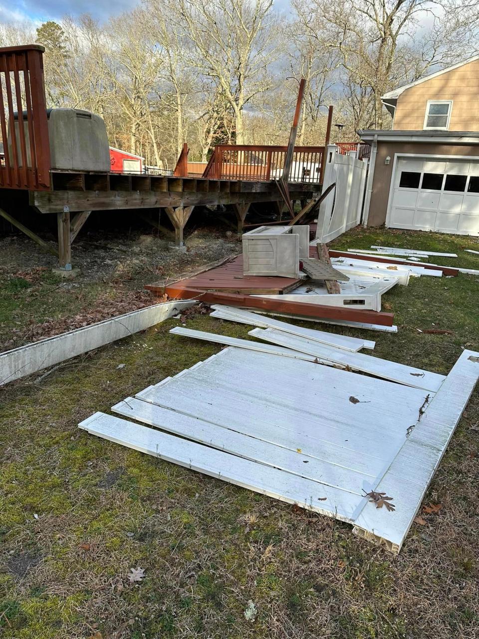
The tornado then moved over the county line between Monmouth and Ocean, where it appears to have strengthened to its greatest intensity when it struck a neighborhood on the southwest corner of Spicy Pond Road in Howell. Numerous large trees were snapped or uprooted in convergent pattern in an area 300 yards long and 150 yards wide. Fences were demolished, and several houses sustained minor to moderate damage impacting siding, roof shingles, gutters, an awning and a deck. The worst damage occurred to a house facing the southwest, on the southwest corner of the residential street. The roof of the house was lifted off the structure and tossed into the backyard and the backyard of an adjacent neighbor's, the weather service explained in a report Monday afternoon about this weekend's storm.
Some of the debris, including a piece of a roof rafter — the sloped wooden beams of the structure — was lifted into the sky about 125 yards, impaling the roof and second floor of a house on the east side of Addison Road, not far from where the twister began to dissipate.
Some siding from the house was impaled into the siding of the neighboring house to the north, with insulation and siding debris littering the neighborhood for about 200 yards to to the southeast, all according to the weather service. Based on the degree of damage, the winds were estimated to be about 110 to 120 mph when the tornado slammed into the neighborhood. The vortex is thought to have fizzled out after passing Addison Road, all according to the weather service.
Sea Girt tornado
A few minutes later at 7:42 p.m., another EF-2 tornado made landfall 15 miles away in Sea Girt, on the grounds of the National Guard Training Center at the corner of Sea Girt Avenue and Route 35.
The weather service said that tornado likely formed over Stockton Lake and tracked east-southeast overthe New Jersey Youth Challenge Academy — which is located on the campus of the military facility — along Camp Drive. The entire half-dome, wooden-framed, shingled-roof of the school — about 25 yards wide and50 yards long — was lifted off the building and tossed eastward. The semi-circled debris field with drag marks extended for about 250 yards to the east-northeast. One tree was uprooted and fell in an northeast direction. The tornado likely lifted as it tracked east across the parking lot and open grass fields, according to the weather service.
The weather service has concluded that 110 to 120 mph winds must have caused the damage. This tornado traveled just 0.14 miles, the report said.
Damage elsewhere around Sea Girt and in neighboring Manasquan appears to have been the result of "straight line winds," rather than the result of the same or another smaller tornado. Straight line winds are thunderstorm winds that are a common cause of wind damage that are often mistaken for tornadoes. Such gusts can reach more than 100 mph and are caused by air being dragged down by precipitation.
For example, the weather service reported that a small bleacher that overturned at the Manasquan Little LeagueFields, about 600 yards southeast of New Jersey Youth Challenge Academy in Sea Girt, was consistent with straight line winds of 70 to 80 mph — which was similar to the wind speeds measured elsewhere in the area at the time.
Cinnaminson tornado
An EF-1 touched down near the intersection of Riverton Road and Woodside Lane in Cinnaminson at 6:59 p.m. and lasted for four minutes and traveled for six miles before it dissipated over neighboring Moorestown at 7:03 p.m. Saturday, according to the weather service.
Damage was reported in the neighborhoods around Cinnaminson High School and Eleanor Rush Intermediate School, where wind gusts of up to 100 mph peeled off the roof a single-family home and knocked down a swath of trees in Lakeview Memorial Park before spinning into Delran and the 34-acre Esther Yanai Preserve in Moorestown. Several other homes in the path of the tornado sustained minor damage to their roofs and sidings; a utility pole also snapped during the event, the weather service reported.
New Jersey tornadoes
Damaging tornadoes are not anomalous events to New Jersey, though the state has never recorded a tornado greater than an EF-3 — which produces wind gusts of between 136 to 165 mph. An EF-4 has winds of 166 to 200 mph.
Only one known fatality has resulted from a tornado in the state since the 20th century, although others are known to have previously perished in such an event. In 1835, five people were killed when a tornado touched down in New Brunswick, according to state climatology records.
Since 1950, five EF-3 tornadoes have been recorded in New Jersey; the last EF-3 was on Sept. 1, 2021 when one cut a 12-mile path through several Gloucester County towns. No one was killed but two people were injured and winds clocked at 150 mph left behind $5 million in damage.
Before this weekend, 33 EF-2 tornadoes had been recorded in New Jersey in the past 73 years. The last EF-2 to hit New Jersey was a little more than a month ago — on Feb. 21 — in Mercer County. The weather service said no one was injured in that twister’s 115 mph winds, which was only the second EF-2 on record to hit New Jersey in the month of February.
Before this past weekend, the last EF-2 to hit the Jersey Shore at any time during the year was on July 29, 2021.
That tornado barreled across Barnegat Bay and into a two-story house in the High Bar Harbor section of Long Beach Township. As the top of the home peeled away in 115 to 120 mph winds, its occupants took shelter in an interior closet. What remained of the roof went airborne and slammed into multiple other homes in the neighborhood. Eight people were injured.
As to the frequency of tornadoes in New Jersey, no pattern has been established. According to state climatology records, a list of the top 10 years with the most tornadoes — since 1950 — is this:
1989 - 19 tornadoes
2021 - 13 tornadoes
1987 - 9 tornadoes
2019 - 9 tornadoes
1973 - 8 tornadoes
1990 - 8 tornadoes
1994 - 7 tornadoes
2003 - 7 tornadoes
1964 - 6 tornadoes
1988 - 6 tornadoes
“You can see how they vary so much from year to year,” Robinson said of the data recorded on the Rutgers New Jersey Agricultural Experiment Station. “There is no trend there. I would contend early in the record there was not as abundant reporting, so there were probably a few more (tornadoes) in there that never got reported.”
The weather service said it would have more information on Tuesday about the Allentown-Upper Freehold and Chesterfield tornadoes.
Contact Asbury Park Press reporters Erik Larsen or Jenna Calderón at elarsen@gannettnj.com or jcalderon@gannettnj.com, respectively.
This article originally appeared on Asbury Park Press: NJ tornadoes: Ocean and Monmouth counties hit with EF-2s

