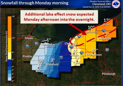
Winter storm warning; 6-7 inches of snow now predicted in Akron-Canton area
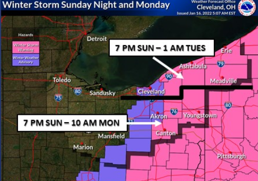
A winter storm warning has been issued for part of the Akron-Canton region with 6-7 inches of heavy, wet snow forecast Sunday night into Monday, the National Weather Service said.
Snow will begin falling Sunday evening, but forecasters believe the heaviest snow will fall east of the region.
Snowplow crews and commuters who work on Martin Luther King Jr. Day could face an additional 1 to 2 inches on Monday, with an 80% chance during the day. Temperatures are forecast to remain below freezing, with a high of 28 forecast.
The winter storm warning includes Stark and Portage counties and all points east, where as much as 10 inches could fall in Youngstown. Summit, Medina and Wayne counties are under a winter weather advisory.
Snowbelt counties to the north may face higher snowfalls.
Winter Storm Izzy to strike Sunday
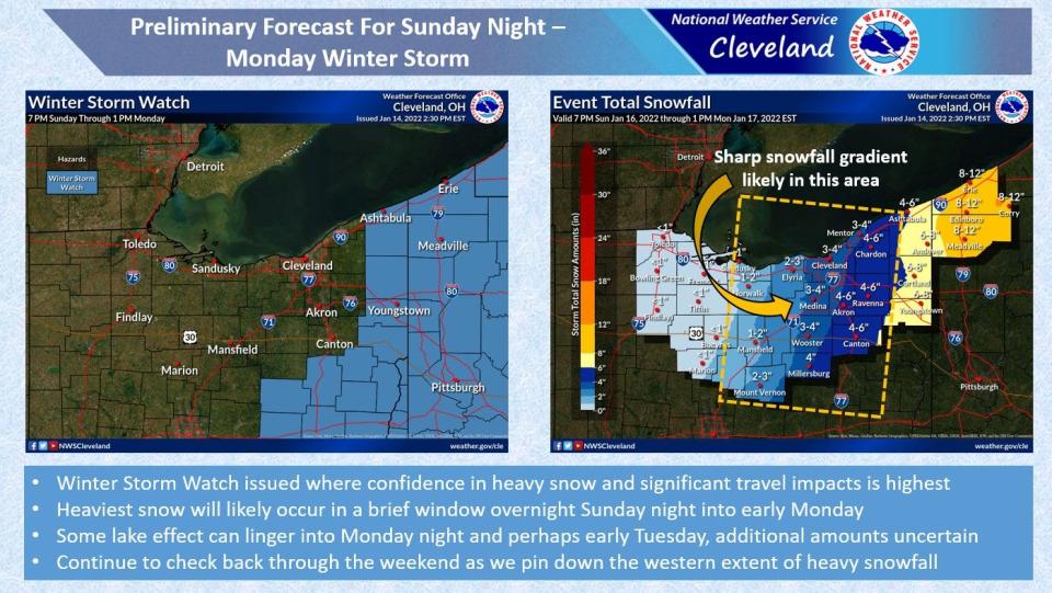
The possibility of heavy snowfall has increased as Winter Storm Izzy moves into the area Sunday.
Storm heading this way: Widespread snow expected across northern Ohio Sunday night into Monday
The heaviest snow will likely be over the Appalachians, but forecasters say the potential for accumulating snow in Northeast Ohio has been increasing. Counties in southern and eastern Ohio into Pennsylvania have the greatest chance of seeing heavy snow.
Tips for the roads: Driving in northern Ohio this winter? These tips will help you get there safely
What remains unknown is the storm's final track, the exact western edge of accumulating snow, how much snow will fall and the amount of lake-effect snow that could follow.
Current Akron-Canton forecast
Here is the forecast as of 8:30 a.m. Sunday from the National Weather Service.
Today: A chance of snow after 5 p.m. Increasing clouds, with a high near 35. East wind 9 to 11 mph. Chance of precipitation is 30%. Total daytime snow accumulation of less than a half inch possible.
Accuweather: Updated forecast and conditions
Tonight: Snow. The snow could be heavy at times. Low around 26. East wind 8 to 16 mph becoming northwest after midnight. Chance of precipitation is 100%. New snow accumulation of 4 to 8 inches possible.
M.L.King Day: Snow, mainly before noon. High near 29. Breezy, with a west wind 17 to 20 mph, with gusts as high as 31 mph. Chance of precipitation is 80%. New snow accumulation of 1 to 2 inches possible.
Monday Night: A chance of snow showers. Mostly cloudy, with a low around 20. West wind 11 to 17 mph. Chance of precipitation is 50%. New snow accumulation of less than a half inch possible.
Tuesday: Partly sunny, with a high near 32. Southwest wind 8 to 10 mph.
Beacon Journal reporter Alan Ashworth contributed to this article. Eric Marotta can be reached at 330-541-9433, or emarotta@gannett.com. Follow him on Twitter @MarottaEric.
This article originally appeared on Akron Beacon Journal: Northeast Ohio weather forecast: Winter storm Izzy bringing heavy snow

