4th nor'easter this month takes aim at East Coast with jet stream stuck on repeat

UPDATE: March 20, 2018, 10:23 a.m. EDT Based on the latest computer model runs and extensive experience forecasting Mid-Atlantic snowstorms, the National Weather Service has leaned toward higher snowfall totals from Washington, D.C. all the way to Boston. The heaviest snow, according to the NWS, is likely to fall from Philadelphia to southern Connecticut, where 12 to 18 inches may pile up.
If this happens, there will be widespread power outages from downed trees and power lines, due to the weight of the snow. To put this in perspective, if New York City's Central Park were to pick up 18 inches of snow out of this storm — and that's a big "if" — it would be the heaviest March snowstorm at that location since 1941.
However, snowfall forecasts will still be adjusted in either direction throughout the day on Tuesday, as the storm begins to take shape, and guidance from higher resolution, short-range computer models becomes more useful.
The calendar may say it's the first day of spring, but it will seem more like the movie Groundhog Day along the East Coast on Tuesday. The fourth nor'easter in just three weeks will begin to take shape across the Mid-Atlantic, as the first of two waves of low pressure spreads a wintry mix of snow, sleet, and rain from West Virginia to Delaware.
The main show, though, appears to be set for Tuesday night through Wednesday night, possibly into part of Thursday, from Washington, D.C. northeastward to Boston. Once again, an atmospheric disturbance diving out of Canada and across parts of the U.S. will spawn an intensifying area of low pressure just off the Mid-Atlantic coast.
SEE ALSO: Third nor'easter in 2 weeks to slam New England: What's going on here?
The same ingredients that have come together to produce blockbuster spring snowstorms three times already this month, including snow totals above 2 feet in some cases, will combine to yield a powerful coastal storm that will throw moisture from the North Atlantic inland, where it will fall as heavy, wet snow.
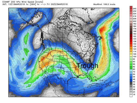
Image: weatherbell analytics.
The previous storms have been high-impact affairs, with tens of thousands without power from each event, as the wet snow brings down trees and power lines, and strong winds take out branches along the shore. This time around, the storm won't be as strong, though power outages are once again possible anywhere the snow accumulates more than about 4 inches, which as of Monday evening appeared to be the most populated stretch of the country, including the cities of D.C., Baltimore, Philadelphia, New York, Hartford, Providence, and Boston.
In urban areas, the high sun angle of mid-March may make it difficult for the snow to stick on roadways, but as long as it snows at a heavy rate of 1 to 3 inches per hour, snow should accumulate.
Boston added to the Nor'easter Number 4 snowfall club of 10-inches+ along with Philly, NYC and points in between getting a dime.
Nearly 37-million population to see at least 6-inches of snow. pic.twitter.com/oyzqZe4SMX— Ryan Maue | weather.us (@RyanMaue) March 19, 2018
Correction (Thanks @TimNBCBoston): There have only been 4 *March* #snow events of 1-foot or more at #NYC Central Park since 1869. #WinterStormToby has a chance of being the first to occur in *late* March, there. (Data: @NWSNewYorkNY) pic.twitter.com/23YgVudpK3
— Jonathan Erdman (@wxjerdman) March 20, 2018
The forecast details will shift as the storm gets closer and computer models and the human forecasters that utilize them refine their projections, but the large-scale atmospheric setup remains similar to what it was back on March 2, when the first major nor'easter walloped the East Coast.
A couple of key factors have persisted this March that have sparked storms near the East Coast and caused them to get hung up there. A dip, or trough, in the jet stream exists across the east. Upstream, across northeastern Canada, parts of the North Atlantic, and southern Greenland, weather systems are configured in a way that effectively blocks storms from moving off the East Coast.
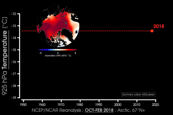
Image: NCEp/ncar via zack labe.
This allows them to intensify before moving out to sea, and be slow-moving enough to bring high snow totals, strong winds, and potentially damaging coastal flooding.
The repetitive winter storms this March fit the climate change narrative that some researchers have been putting forward for several years now through peer-reviewed research. Specifically, as Arctic temperatures increase due to human-caused global warming, and sea ice is reduced, it is having ramifications throughout midlatitude weather patterns. The Arctic had one of its warmest winter seasons on record this year, with sea ice hovering near or at record lows.
One study, published in Nature Communications on March 13, provides statistical evidence of links between "an unusually warm Arctic and cold continents." What's more, this study, which builds off other previously published work, showed that the influence of Arctic warming is most likely to be felt in the eastern U.S. during mid-to-late winter, rather than early on in the season.
"... We show that in the period of accelerated Arctic warming, heavy snowfalls in the Northeastern U.S. have become more frequent," said Judah Cohen, chief seasonal forecaster at AER, a Verisk company, via email. "So though a heavy snowfall in March is not unheard of or rare it is the frequency of the heavy snowfalls that seems to be changing."
While statistical links have been put forward between Arctic warming and particular weather patterns in the midlatitudes, the precise physical mechanisms through which these effects are occurring have not yet been proven, and research is ongoing.
