Five Atlantic systems include tropical storms Emily, Franklin, Gert. And soon, Harold
The Atlantic is alight this week with five systems, three already named and two right on the verge. While none currently pose a threat to Florida, one is set to lash Haiti and the Dominican Republican as a tropical storm in the coming days, and another could soak Texas and Mexico.
Just two weeks ago, NOAA upped its storm count predictions for the year, thanks mostly to a super-heated Atlantic that makes storm formation — and strengthening — easier. However, the storm-snuffing power of global weather phenomenon El Niño appears to be in play as well, as most of the storms on the board in the Atlantic are set to be short-lived and stay far away from land.
All but one system in the Atlantic had a forecast track and designation by Monday evening, leaving only a disturbance in the far east Atlantic with a medium chance of developing in the next few days, but a 70% chance within the week.
Here’s what forecasters wrote in the hurricane center’s Monday 5 p.m. advisories:
Tropical Storm Franklin threatens Haiti, the Dominican Republic
On Monday, Tropical Storm Franklin had the southern coast of Haiti and the Dominican Republic under a tropical storm warning. The north and east coast of the Dominican Republic, as well as the Turks and Caicos Islands, were under a tropical storm watch.
Its maximum sustained winds were around 50 mph and it was about 290 miles south of Santo Domingo, the capital of the Dominican Republic, headed west at 5 mph.
Monday afternoon, a reconnaissance plane found the center of the storm was more southern than computer models suggested, and forecasters said Franklin spent much of Monday “meandering.” The latest forecast leaves the storm over the Caribbean Sea for a little longer and shifted the track to the west.
The storm was expected to turn north on Tuesday and cross the island as a tropical storm later that evening, bringing heavy rain and raising the possibility of mudslides. Exactly when it would begin that turn, or how far east or west the track could swing, was still uncertain as of Monday afternoon, forecasters said.
For now, the hurricane center’s forecast calls for a track leaning east into open water, where Franklin could have the opportunity to strengthen into a hurricane — the second of the season.
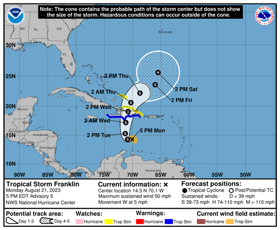
Franklin was forecast to bring 5 to 10 inches of rain across Haiti and the Dominican Republic, possibly reaching 15 inches in some areas. Most of Puerto Rico could get 2 to 4 inches of rain with certain areas getting 6 inches.
READ MORE: Tropical Storm Franklin’s possible impact on Haiti and the Dominican Republic
Tropical Storm #Franklin has formed in the eastern Caribbean - the 7th named storm of 2023 Atlantic #hurricane season to date (subtropical storm formed in Jan). Since 1960, 7 other years have had 7+ named storms by Aug. 20: 1995, 2005, 2011, 2012, 2017, 2020, 2021. pic.twitter.com/SOx6rDt82g
— Philip Klotzbach (@philklotzbach) August 20, 2023
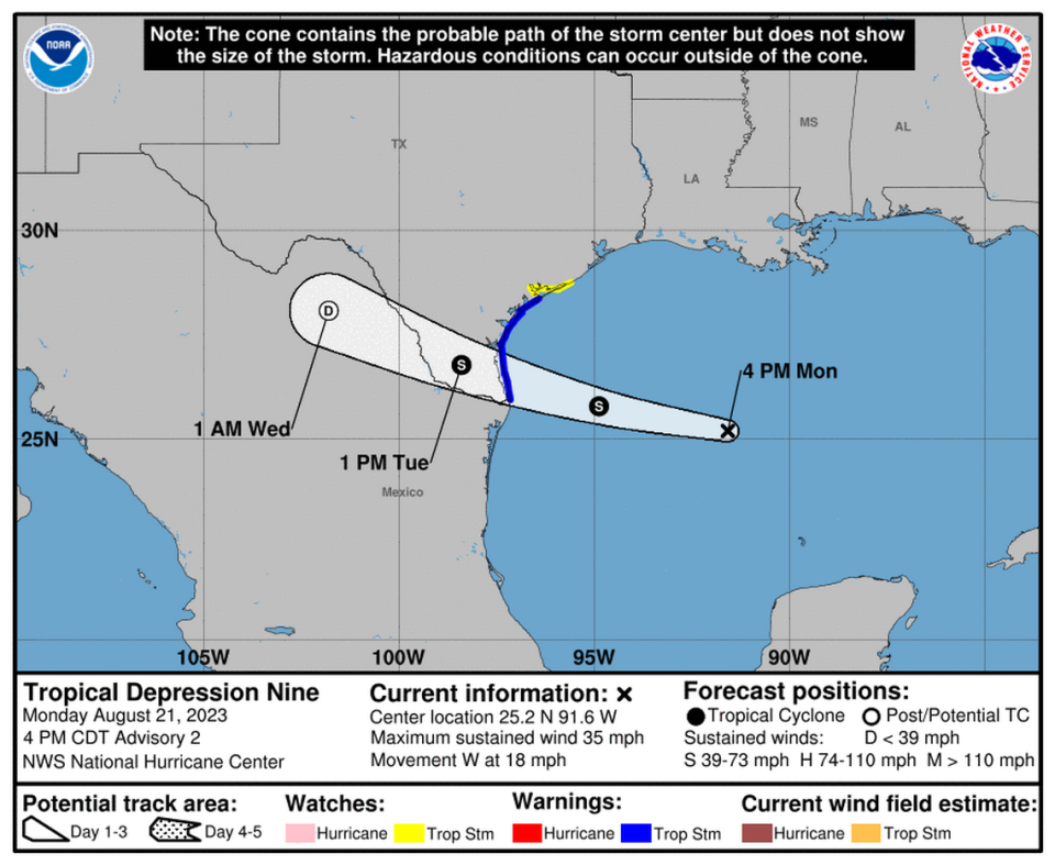
Tropical Depression 9 heads toward Texas
Tropical Depression 9 formed Monday afternoon just off the coast of Texas. The system was expected to power up into a tropical storm — potentially, Harold — Tuesday morning just before making landfall on Texas’ southeast coast.
That portion of the coast was under a tropical storm warning as of Monday evening, with a tropical storm watch issued for some miles of coastline to the north. The storm could bring heavy rains and raise the risk of coastal flooding.
Forecasters said the system had sustained winds around 35 mph on Monday afternoon and was moving quickly to the east at 18 mph. The system was expected to pick up the pace as it streaks toward Texas on Tuesday.
Initial outer bands of the storm began hitting Texas Monday night, the hurricane center said. Over the next day it’s expected to bring heavy rains and up to three feet of storm surge.
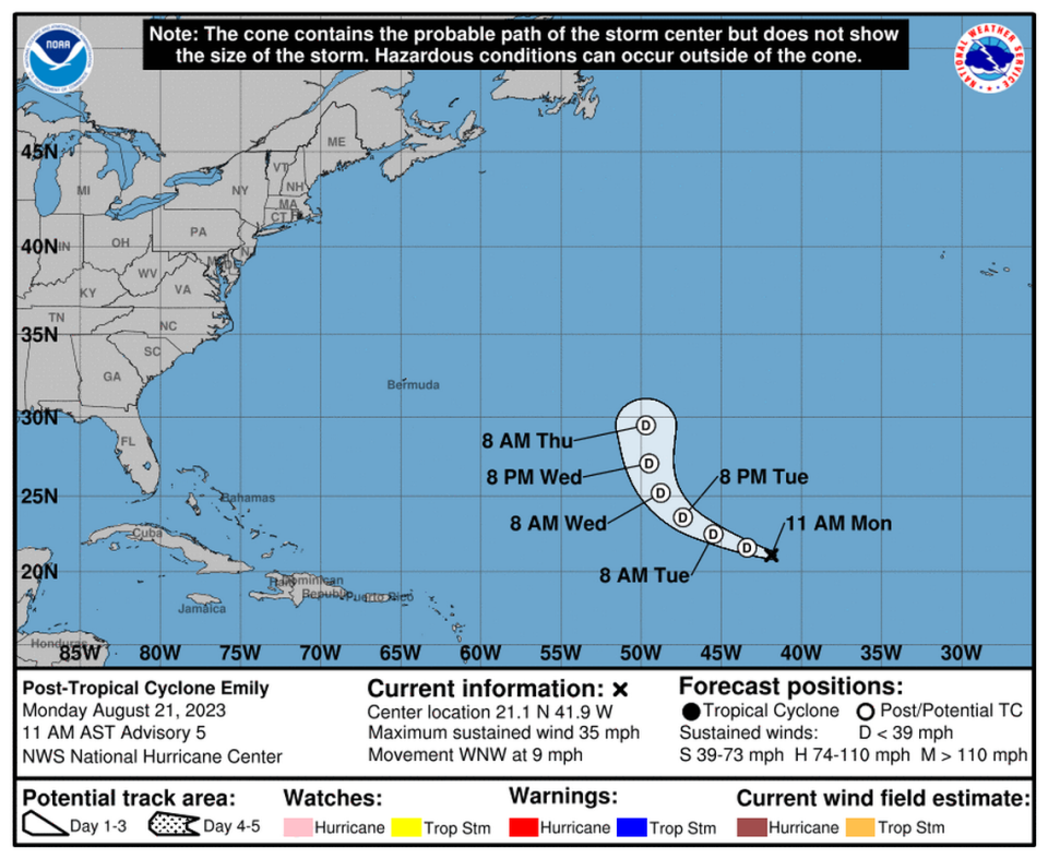
Tropical Storm Emily weakens
After a rough night in the deep Atlantic, Tropical Storm Emily was downgraded to a post-tropical cyclone or remnant low Monday morning.
As of 11 a.m., the hurricane center said “strong wind shear and a very dry environment should prevent it from re-organizing as a tropical cyclone for at least the next couple days.”
Forecasters said Emily had a slim chance of regaining tropical storm status in about three days when it turns north, but they considered the chances so rare they didn’t include it in the forecast map.
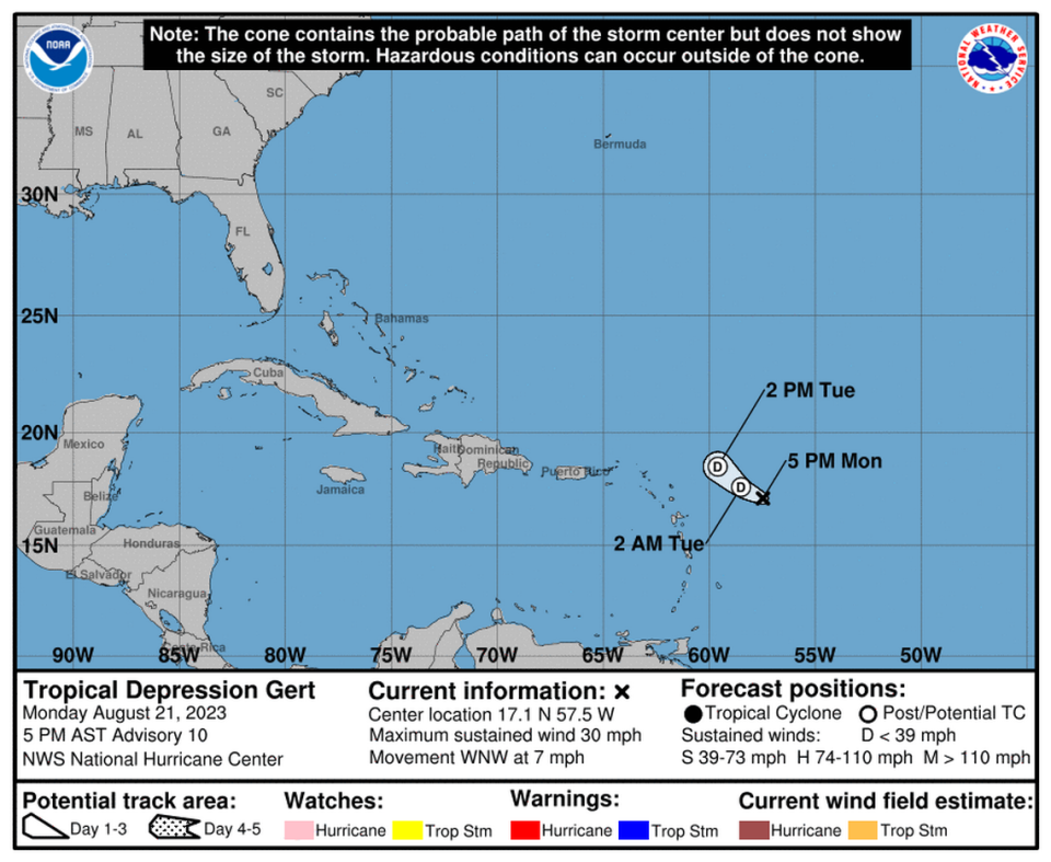
Tropical Storm Gert nearly gone, already
Tropical Storm Gert formed Saturday evening, but by Monday morning it was already “quickly unraveling,” according to the hurricane center.
The short-lived storm was expected to dissipate “at any time,” but likely by Tuesday. As of Monday evening, it was hundreds of miles east of the nearest island chain, the Northern Leeward Islands with maximum sustained winds hovering around 30 mph.