5 Atlantic systems now include Tropical Storm Emily and a disturbance entering the Gulf
A disturbance became Tropical Storm Emily Sunday morning as the Atlantic Ocean’s warm waters continued to crank out tropical systems being watched by the National Hurricane Center.
One of those systems moved over the Florida Keys Saturday night on its way into the Gulf of Mexico.
Here’s what National Hurricane Center specialists wrote in the Hurricane Center’s Sunday morning advisories:
Which system will affect the Gulf states, including MS?
The Hurricane Center is watching Disturbance 3, a disturbance over the Florida peninsula that is expected to move into the Gulf of Mexico by early next week.
“Some slow development of this system could occur thereafter as it moves westward at about 15 to 20 mph, and a tropical depression could form as it approaches the western Gulf of Mexico coastline by Tuesday,” the NHC said.
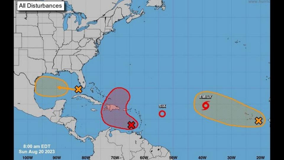
If the system develops next week it will have moved beyond the state and into the western Gulf of Mexico coastline area. Residents in Texas, Mississippi and Louisiana should keep an eye on the disturbance and check hurricanes.gov for updates.
▪ Formation chance through 48 hours: 30%, up from 20% at the 8 p.m. Saturday advisory.
▪ Formation chance through 7 days: 50%, the same as the 8 p.m. Saturday advisory.
“The quick pivot from an empty ‘tropical storm formation not anticipated’ NHC map to one crowded with possible hurricane seedlings is having its moment on social media”
My analysis on the suddenly busier Atlantic https://t.co/F1CLELxhu7— John Morales (@JohnMoralesTV) August 18, 2023
What should NC & SC know?
As of 10 a.m. Saturday, there is no threat North Carolina, South Carolina or Georgia over the next seven days.
Weather forecasters will know more about tracks of the systems if they develop further.
Check hurricanes.gov for the latest updates.
Where’s Tropical Depression 6?
The sixth tropical depression of the 2023 hurricane season formed around 5 p.m. Saturday. Forecasters don’t expect it to be around long.
It is about 680 miles east of the Northern Leeward Islands and traveling west at 15 mph, the hurricane center said. It has maximum sustained winds near 35 mph with higher gusts.
The depression is forecast is to weaken over the next day or so, becoming a remnant low by Monday.
No coastal watches or warnings are in effect.

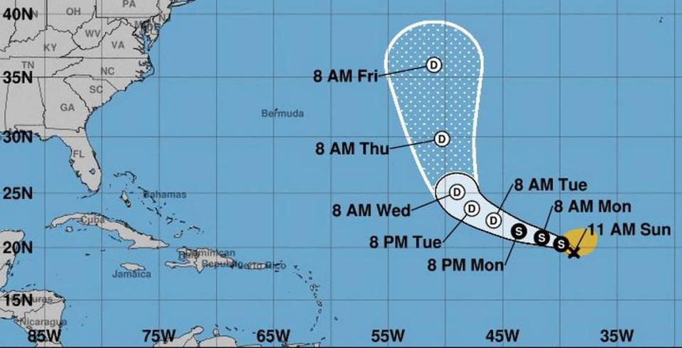
Disturbance 1 is now Tropical Storm Emily
Tropical Storm Emily is now about 1,000 miles west-northwest of the Cabo Verde Islands with 50 mph maximum sustained winds. Tropical storm force winds extend 185 miles from the storm’s center. It’s moving west-northwest at 10 mph.
Storm warnings or watches: None.
Forecast: “Little change in strength forecast today followed by gradual weakening. Emily is likely to become a post-tropical remnant low by Tuesday,” the NHC said in its 11 a.m. advisory.
Where’s Disturbance 2?
Near the Windward Islands, a broad area of low pressure is becoming better organized.
The NHC expects a tropical depression to form Sunday or Monday as it moves west or west-northwest at 10 to 15 mph over the eastern and central Caribbean Sea. The expected track takes it north and into the southwest Atlantic Ocean by Wednesday.
“Regardless of development, heavy rainfall is possible over portions of the Windward Islands during the next couple of days. Interests in the eastern and central Caribbean should monitor the progress of this system,” the hurricane center said.
▪ Formation chance through 48 hours: 70%, up from 50% at the 8 p.m. Saturday advisory.
▪ Formation chance through 7 days: 80%, up from 70% at the 8 p.m. Saturday advisory.
How about Disturbance 4?
A tropical wave is being tracked near the western coast of Africa and is producing a large area of disorganized showers and thunderstorms.
“Environmental conditions appear conducive for gradual development of this system, and a tropical depression could form later this week while it moves west-northwestward across the eastern tropical Atlantic,” the NHC said.
▪ Formation chance through 48 hours: 10%, up from near 0% at the 8 p.m. Saturday advisory.
▪ Formation chance through 7 days: 50%, up from 30% at the 8 p.m. Saturday advisory.
Biloxi Sun Herald reporter Justin Mitchell contributed to this report.

