Severe weather danger triggers second 'high-risk' threat in a week


AccuWeather meteorologists continued to warn on Thursday that a life-threatening severe weather outbreak looms across a large part of the southern United States stretching from the Gulf Coast to the Ohio Valley, with the potential for dangers to linger into the nighttime hours. At least 50 million Americans are in the path of severe weather, including storm-weary residents of the Mississippi Valley still recovering from destructive tornadoes just over a week ago.
AccuWeather Chief On-Air Meteorologist Bernie Rayno pointed out that words like "possible" or "likely" are not on the forecast maps for Thursday and Thursday night. "These are definite," he warned. "There's going to be a tornado outbreak. There's going to be widespread wind damage, and there's going to be hail," he added.
 |
The storm set to trigger the severe outbreak shifted east out of the southern Rockies, where heavy snow was falling on Wednesday before producing thunderstorms and large hail across the southern Plains into Wednesday night.
Some hail reports across Texas were as big as pool balls and baseballs.
 |
All the right conditions were forecast to setup again Thursday to Thursday night, especially across the northern parts of Mississippi and Alabama into eastern Arkansas, the northeastern corner of Louisiana and western and central Tennessee, indicating the threat for more severe weather.
By midday on Thursday, severe weather was already unfolding across the south, prompting tornado watches and warnings to be issued in Mississippi and Alabama.
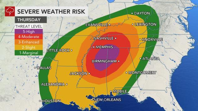
For the second time in a week, the National Weather Service's Storm Prediction Center (SPC) has issued a high risk of severe weather. This corresponds to a level 5 on the National Weather Service's severe weather alert scale. The lowest level or 1 corresponds to a marginal risk, while a level 5 represents a high risk.
 |
High Severe Weather Risk 3/25 |
The last time that SPC issued two high risks for severe weather in the month of March was 30 years ago in 1991.
This is the second of two storms to threaten severe weather in just one week. Portions of the lower Mississippi and Tennessee valleys were hit with destructive severe weather and tornadoes. During St. Patrick's Day, March 17, alone, 56 reports of tornadoes, 27 incidents of large hail and 79 episodes of damaging wind gusts were tallied by the SPC.
Alabama was dealt some of the most destructive severe weather last week. An EF2 tornado touched down in Chilton County on Wednesday, spawning 130-mph winds. An EF1 tornado packing 110-mph winds struck Moundville, Alabama, causing severe damage to buildings and ripping roofs off homes.
AccuWeather meteorologists believe that some risk of severe thunderstorms and perhaps an isolated tornado exists as far north as the Ohio Valley, but the greatest threat of tornadoes will be farther south from Tennessee to near Interstate 20 in Mississippi and Alabama. Storms that cruise through the Ohio Valley are expected to unleash the threat of damaging wind gusts.
Severe weather will be underway during the early to middle part of the afternoon as discrete thunderstorm cells are expected to erupt across areas like Mississippi, Alabama and northward into Tennessee, according to Rayno. Thunderstorms that ignite in this manner, rather than as part of a more organized line can be particularly dangerous and are most likely to spawn tornadoes.
CLICK HERE FOR THE FREE ACCUWEATHER APP
There is still some risk of storms capable of producing tornadoes after dark, but this should be more of an exception now thanks to the shift of daylight hours associated with daylight saving time now in effect. Late-night tornadoes appear to be unlikely at this point, but AccuWeather meteorologists will continue to closely monitor the situation.
Nighttime tornadoes, especially those that occur late at night, are especially dangerous as many people may not know a storm is heading to their neighborhood unless closely monitoring severe weather watches and warnings.
The AccuWeather app is a valuable tool in keeping up-to-date with severe weather with up-to-the-second warnings.
Any thunderstorm in the alert zone can easily produce wind gusts between 40 and 60 mph with an AccuWeather LocalStorm Max™ of 80 mph. At this force, there is the risk of property damage, falling trees and sporadic power outages.
In addition to the likelihood of violent thunderstorms, there remains a significant risk of flooding over the same general area of the nation.
As the first storm system encountered Gulf of Mexico moisture into Tuesday night, gusty and locally drenching thunderstorms led to incidents of flash and urban flooding along the northern part of the Gulf coast.
 |
This graphic depicts the amount of rain that fell on Louisiana on Tuesday, March 23, 2021. (AccuWeather) |
National Weather Service hydrological data indicated that the Contraband Bayou near Lake Charles, Louisiana, rose rapidly to major flood stage on Tuesday morning in response to heavy rainfall. Flood stage for the site is 8 feet, but the level had reached 12 feet at the start of the day on Tuesday. Major flooding begins at 10 feet. More incidents such as this are anticipated in the coming days from the Mississippi River Delta region through the Tennessee Valley.
From noon Tuesday to 8 a.m. Wednesday, more than 6 inches of rain fell on New Orleans and triggered incidents of urban flooding in the city.
"In the Interstate 10, 20 and 40 corridors in the Mississippi Delta and lower Mississippi Valley region, a general 4-8 inches of rain is anticipated during the middle days of this week, with the bulk of that rain expected to fall from Wednesday to Thursday," AccuWeather Senior Meteorologist Brett Anderson said. Where the heaviest rain pours down and repeats, an AccuWeather Local StormMax™ of 15 inches is anticipated.
 |
"Some of the rain from Tuesday to early Wednesday fell on areas that were hit with flooding downpours during last week's severe thunderstorms," Rayno said earlier in the week.
Rainfall from last week alone was anywhere from two to five times that of average. The bulk of the rain last week fell in two days -- on March 16 and 17.
For example, Meridian, Mississippi, received 4.42 inches of rain on March 16 and 17, compared to a normal of 1.21 inches of rain for the third week of the month. Meridian is within the zone of anticipated heaviest rainfall at midweek.
Birmingham and Huntsville, Alabama, are forecast to be within the zone of the potentially excessive rainfall this week, and both locations received about 4.5 inches of rain on March 16 and 17.
Other cities that have the potential to experience problems from excessive rainfall this week include Memphis and Nashville, Tennessee; Little Rock, Arkansas; Jackson and Tupelo, Mississippi; and New Orleans and Baton Rouge, Louisiana.
This reoccurring rainfall has the effect of keeping the ground wet. The fact that flooding may not have occurred in some communities yet does not mean these same areas are immune to flooding into Thursday night.
The latest surge of wet weather into Thursday night is forecast to be intense and persistent enough to raise the risk of small stream flooding and rises on the rivers, in addition to the likelihood of urban flooding.
Some rivers in the region that could experience significant rises during the middle and latter part of this week after runoff flows downstream from smaller tributaries include the Pearle, Alabama, Tennessee, Yazoo, Chickasawhay and Tombigbee.
Levels along much of the lower portion of the Mississippi River from southern Missouri and Illinois to Louisiana were at minor flood stage at midweek due to melting snow and episodes of rain during the last part of the winter. Some fluctuation in the Mississippi is anticipated in the coming weeks and months due to additional rainfall in the short and long term.
Water levels on the lower portions of the Chickasawhay and Pearle rivers were close to moderate flood stage at midweek and were forecast to fluctuate, according to National Weather Service hydrological data. Surges of water from last week's and this week's rainfall were factors.
However, even farther north, a general 2-4 inches of rain is forecast to fall through Thursday evening. This can be enough to lead to urban and small stream flooding along the western slopes of the Appalachians and the Ohio Valley with hilly terrain in the region playing a role in rapid runoff.
The combination of heavy rain and some melting snow during late February led to flooding of small streams and rivers in parts of Kentucky, Tennessee and West Virginia.
Officials and the National Weather Service credited preparation and the actions of residents when warnings were issued in the path of severe weather with the fact that no fatalities occurred amid the outbreak in the area during last week.
More recently, an episode of severe weather occurred from late Monday afternoon into Monday night across portions of western and central Texas, with at least one confirmed tornado and more than two dozen damaging wind and hail reports, according to the SPC.
On Monday night, high wind gusts up to 78 mph were reported in West Texas. The severe weather damaged the roofs of multiple homes in Plains, Texas, according to SPC. In Bertram, Texas, there were reports of multiple power lines down and debris blocking roadways following a tornado-warned storm. The National Weather Service survey team indicated that a tornado did not touch down, but strong straight-line winds led to extensive damage.
A Storm Survey found straight-line wind damage in Bertram. This graphic shows the anatomy of a microburst. The hook echo took on a bowing appearance indicative of straight-line winds which matched the damage pattern. Other features are also explained.https://t.co/vJ9Q0bqebX pic.twitter.com/p3AHUejdHX
— NWS Austin/San Antonio (@NWSSanAntonio) March 23, 2021
Pictures on Twitter showed extensive damage to buildings around town. Hailstones as large as 2-3 inches in diameter were also reported across central Texas from Monday's storms.
AccuWeather meteorologists have been tracking the threats for this week even as the severe weather was underway last week -- and forecasters will continue to provide updates on the severe weather and flooding risks this week. People are urged to take the threat of severe weather seriously and have a plan of action in place before storms strike.
Keep checking back on AccuWeather.com and stay tuned to the AccuWeather Network on DirecTV, Frontier, Spectrum, FuboTV, Philo, and Verizon Fios.
