59th Anniversary of the Palm Sunday Tornadoes

GRAND RAPIDS, Mich. (WOOD) — Today (Thu.) marks 59 years since the Palm Sunday tornado outbreak that killed 271 people in the Midwest.
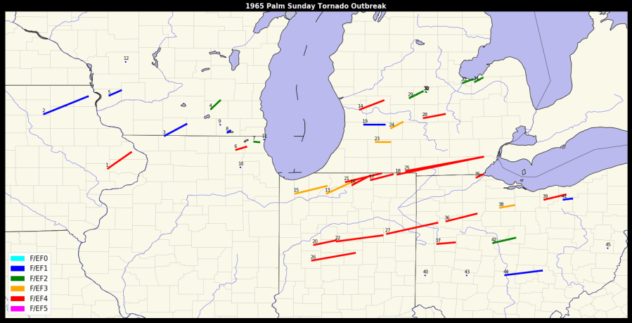
Storms on April 11, 1965, spawned a total of at least 47 tornadoes in six states, including Lower Michigan.
At least four of the twisters in Michigan were F4s: one that rushed across Ottawa, Kent and Montcalm counties, two in Branch and Hillsdale counties and one in the Lansing area. There were other tornadoes in Kalamazoo, Hastings, Bay City and Unionville. Alma was hit by two twisters.
In addition to the 271 dead in six states, approximately 1,500 were injured.
he spring of 1965 was cold and stormy. Three feet of snow fell in March at Grand Rapids, making it the snowiest on record. The temperature hit zero degrees on March 27th and ten degrees on April 3rd. Most of the lakes were still frozen over in early April.
This cold and snowy pattern in March is similar to other years that saw big April tornado outbreaks in Michigan. In 1956, 1967 and 1974, very cold weather prevailed into April, followed by a sudden warming. Then the tornadoes came through, soon followed by more cold weather. The brief warming that preceded the tornadoes was the result of strong southerly winds in advance of a strong low pressure center. The weather maps of April 10th and 11th 1965 show a low tracking from the Central Plains into southern Lower Michigan. In the “warm sector” ahead of the low, the temperature rose to 72 degrees at Grand Rapids that Sunday afternoon.
From the NWS: “A line of powerful thunderstorms formed over Iowa during the afternoon then moved into Wisconsin and Illinois. The Severe Local Storm Warning Center of the U.S. Weather Bureau issued a tornado forecast at 1 pm for northern Illinois and parts of adjacent Iowa and Wisconsin. The term “watch” would be used instead of “forecast” for severe weather outlooks after this historic event. Several of the thunderstorms spawned tornadoes, including one that killed three people in southern Wisconsin.”
The storms continued east, crossed Lake Michigan moving from from Illinois into Indiana and Lower Michigan. By 6 pm, two more tornado forecasts were issued, covering the northern half of Indiana and Ohio and the southern half of Lower Michigan. The Michigan forecast offices, including Grand Rapids, were aware of the destruction that had already occurred further west, and began issuing weather bulletins describing the progress of the thunderstorms they were watching on radar

This is as weather map from 7 pm on April 11, 165. Low pressure was located in Central Wisconsin. A warm front extended from the low across Lower Michigan. Temperatures north of the warm front were in the 40s. Temperatures south of the front reached into the 70s. A cold front extended from the low down into eastern Iowa.
Note the dew point front over Lake Michigan. The dew point is the number in the lower left of each station plot. Dew points were near 60 in Lower Michigan, but fell quickly into the 30s in IL and WI. Stars on the map indicate where tornadoes occurred.
Also note the strong surface conversion of air. The wind at Grand Rapids was 20 knots from the southeast, while there was a 15 knot west-southwest wind at Muskegon.
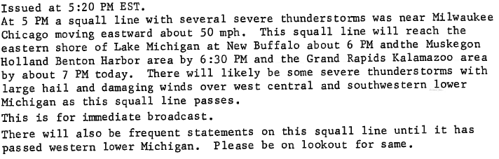
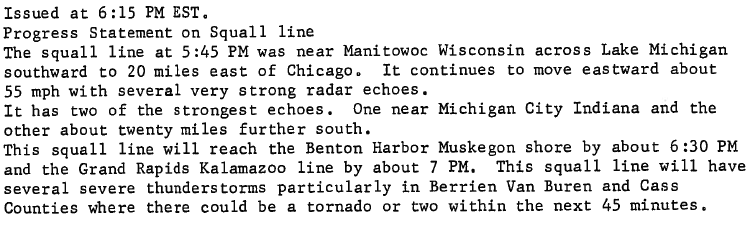
There was no mention of tornadoes in this statement. At the time, the Weather Bureau thought the word “tornado” would cause panic and did not issue a warning until tornadoes were confirmed. The squall line began to intensify as it moved east and word was received that the storms had brought tornadoes to Illinois. The next statement from Grand Rapids at 615 PM expressed how the threat had evolved.
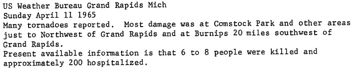
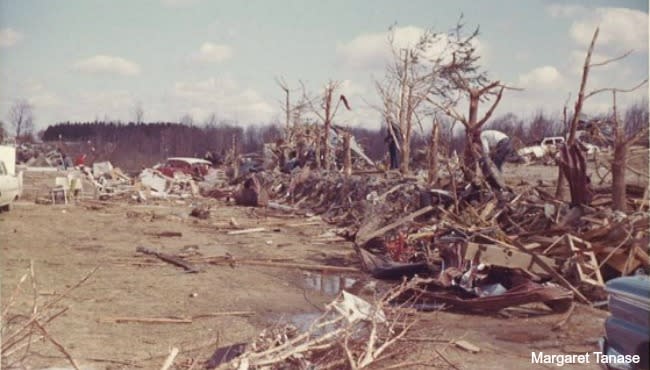
The storms along the squall line moved east and brought tornadoes to Kalamazoo, Allegan and Ottawa Counties. One tornado moved northeast of Kalamazoo and injured 17 people. In Allegan County a tornado killed one person in Burnips. A severe storm intensified as it moved towards Allendale, where a tornado began its 35 mile rampage. It tracked south of Marne then inflicted heavy damage to Alpine Township, Comstock Park, and Rockford before ending near Cedar Springs. Five people were killed and over 100 injured. One of the injured would die days later, raising the death toll to six. Another tornado, probably from the same storm, hit Montcalm and Gratiot Counties, heavily damaging several farms. The Grand Rapids Weather Bureau issued this somber statement after the storms had moved out of West Michigan:
Even worse destruction and loss of life was concentrated further south, where two powerful tornadoes tracked from the Indiana border across Branch County all the way to Washtenaw County, within a mile or so of each other and less than an hour apart. A total of 44 people were killed along the 80 mile path and it was difficult to tell which tornado did what damage or claimed which victims. People that had been hit by the first tornado had to take cover to avoid the second.
After these two tornadoes ended the focus shifted to Ohio, where the northern suburbs of Toledo were visited by a powerful tornado that destroyed entire blocks with many houses levelled to the ground. Vehicles were tossed through the air, including a bus that was lifted and dropped upside down by the tornado, killing five people. The total death toll was 18 for the tornado. As bad as that storm was, communities further south in Ohio saw even worse. A series of deadly tornadoes struck one after another from Lima in western Ohio to Strongsville, southwest of Cleveland, killing more than 40 people. After midnight, when it was finally over, nearly 50 tornadoes had killed more than 250 people in six states. All that was left was a cold wind blowing through areas of devastation filled with shattered lives, farms, businesses and neighborhoods.
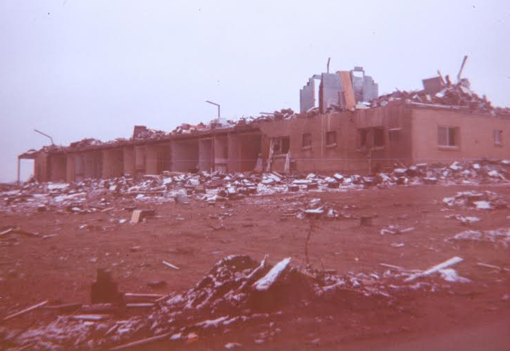
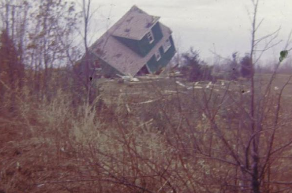
The picture above is the Swan Inn at 6 Mile Road and Alpine Avenue in Comstock Park (by Walter Nelson). A long-track F4 tornado moved from Ottawa Co. into Kent Co. – hitting Comstock Park and Rockford, then moving northeast into Montcalm Co. before dissipating. Here’s stories from survivors. Check out photos from the aftermath of the twister. Major West Michigan tornadoes through the decades.
Two F4 tornadoes struck Branch and Hillsdale Counties 30 minutes apart with 21 lives lost. One tornado had a continuous track of over 90 miles. The twisters moved across Coldwater Lake, Devils Lake, Manitou Beach and Baw Beese Lake destroying hundreds of cottages and homes. A wind instrument near Tecumseh measured a wind of 151 mph in the 2nd tornado. The loss of life would have been much worse, but for the fact that it was still too early for the summer influx of cottage owners and the fact that many residents had left for evening Palm Sunday evening church services.
Another F4 tornado north of Lansing left one person dead and there was a tornado fatality near Middleville in Barry Co. Other tornadoes that day hit north of Kalamazoo (17 injured there), near Hastings, Bay City, Unionville and 2 tornadoes struck Alma. After this event, the Weather Bureau began the Watch/Warning system that is still in use today. Read more here, here, and here. That year we had a record March snowfall (36″) and it was quite cold in March. Hail up to golfball-sized fell with the storms. Check out the Comstock Park Palm Sunday tornado facebook page. Pictures from Marion, Indiana.
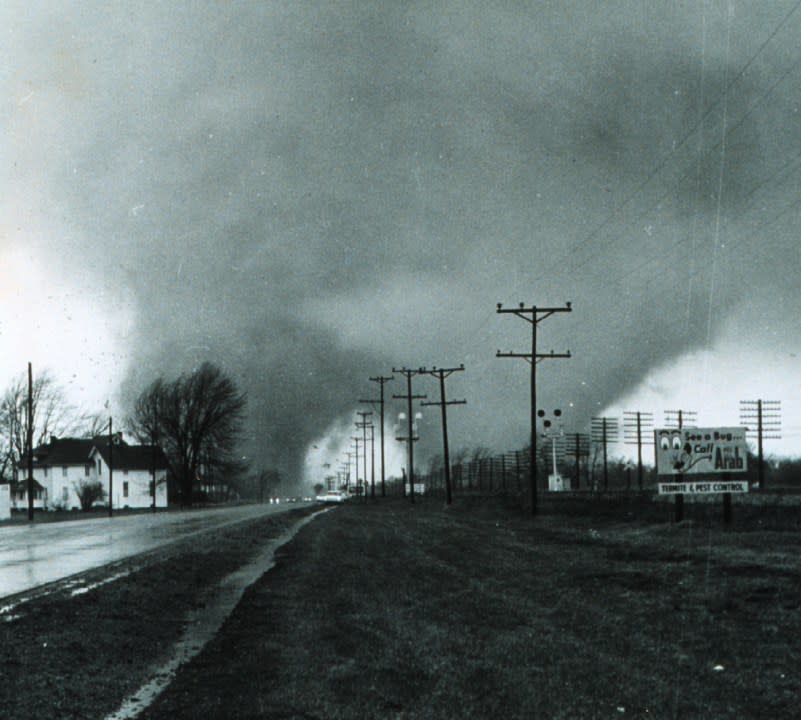
This is a picture of a rare “double tornado” taken Palm Sunday 1965 near Elkhart, Indiana.
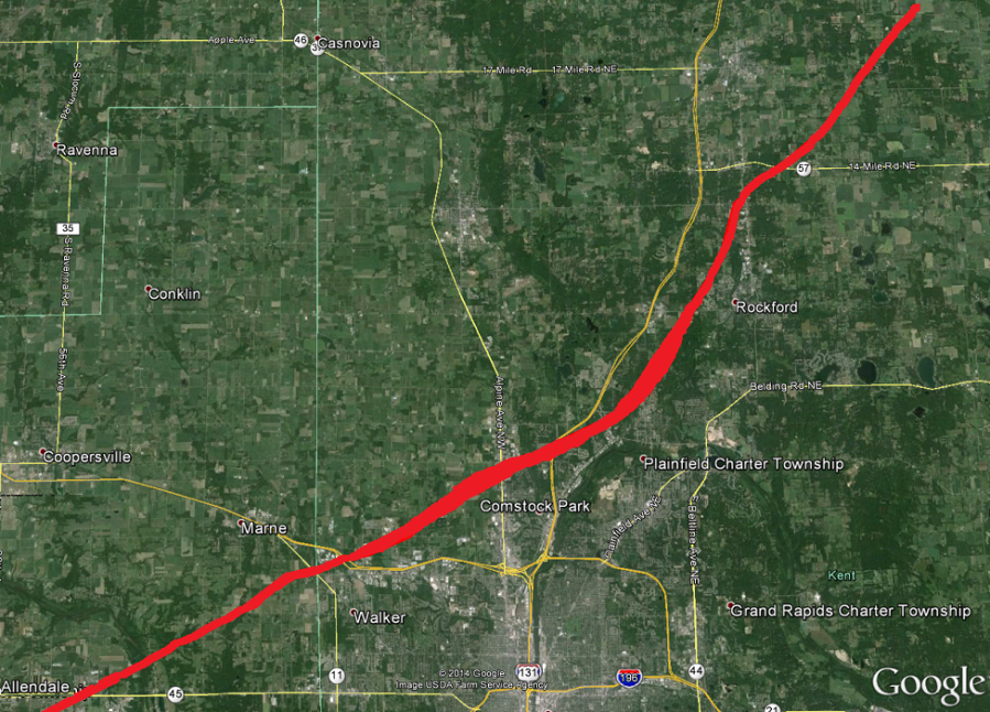
Here’s a map of the path of the Palm Sunday tornado that went through Ottawa and Kent Counties. The tornado formed south of Allendale, came up through Marne into Comstock Park, where it destroyed the Holy Trinity Church in Alpine Township and the Swan Inn Motel/Restaurant on Alpine Avenue (one of the fatalities was there, another across the street). The tornado continued through Rockford to Trufant in Montcalm County.
Supercells produced long-track tornadoes across N. Indiana into S. Michigan and Ohio. Check out Actual pic. of the Branch Co. tornado – what a MONSTER wedge tornado! Spoon wrapped around tree branch! Muncie newspaper day after. More pictures. 1995 special from WSBT on the tornado outbreak. Here’s old film from 1965 – Toledo. Here’s more old film – look at what radar looked like in those days. A lot more people live in the path of these tornadoes 51 years later.

Here’s the 47 tornadoes that occurred that day by F-Scale…there were seventeen F4 tornadoes and another 5 were F3 intensity. The twisters moved through 6 states. Here’s how you can be prepared when severe weather threatens. Scientists explore changes to tornado warnings. West Michigan counties with the highest tornado count. Emergency preparedness for severe storms. Wikipedia article on the Palm Sunday Tornadoes. Five years ago, Alpine Twp. printed The 50th Anniversary of the Palm Sunday Tornado book. In 2015.
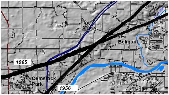
The paths of the Standale/Hudsonville and the Palm Sunday Tornado crossed in Comstock Park close to Samrick Avenue, just north of West River Drive.
Above, Storm Team 8 Chief Meteorologist Emeritus Bill Steffen looks back at the outbreak.
For the latest news, weather, sports, and streaming video, head to WOODTV.com.

