AccuWeather forecasters pinpoint multiple severe weather risks in central US


Even though a widespread severe weather outbreak is not anticipated over the central United States over the next several days, pockets of powerful storms will pose risks to lives and property, AccuWeather meteorologists warn. At the same time, heavy downpours will bring some relief to the long-term drought that has gripped the Plains over many months.
The combination of a persistent dip in the jet stream over the western U.S., pieces of energy moving along in that jet stream, warm air and Gulf of Mexico moisture will pave the way for rounds of showers and thunderstorms over the Great Plains and parts of the Mississippi Valley through this weekend and beyond, extreme meteorologist Reed Timmer recently explained in a video posted to Twitter.
On Sunday, the southern severe weather threat will occur in a strikingly similar area to the day prior. The storms are expected to target areas in Oklahoma along and west of I-35 - including Oklahoma City and Dallas, and locations farther west such as Abilene and Wichita Falls, Texas. The Texas and Oklahoma storms will carry the potential for high winds, damaging hail and a few tornadoes.
 |
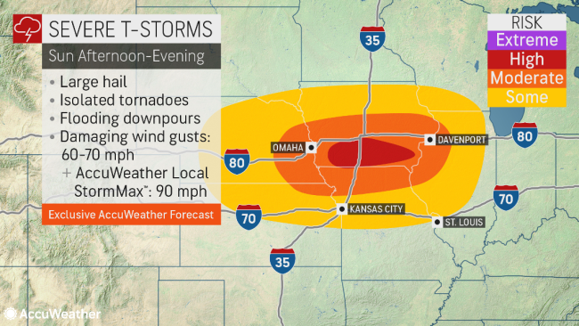
Farther north on Sunday, storms will set also set up in some of the same areas threatened by them the day prior.
Sunday's storms will extend from the central Plains to the middle Mississippi Valley. This includes locations from central Nebraska and northeastern Kansas to much of Iowa, northern Missouri and western Illinois.
All modes of severe weather will be possible on Sunday in this northern zone ranging from damaging winds and hail to localized flash flooding and a few tornadoes. Given an ample amount of wind shear in place, storms are expected to be fairly widespread, and a strong, long tracked tornado cannot be ruled out either.
 |
Rainfall over the Great Plains to the Mississippi Valley in the pattern through the weekend is highly unlikely to have a significant impact on the large rivers. In locations where downpours persist at the local level, flash flooding in urban areas and along small streams is likely.
Since there is some subtropical moisture that will feed into the unsettled pattern through this weekend and into the new week, rainfall may help ease and perhaps even break some of the long-term drought that has been a problem for the Great Plains, Timmer said.
The latest United States Drought Monitor report issued on Thursday still showed vast areas of extreme and exceptional drought over the Plains - the worst two drought categories - despite some improvement following a couple of rainstorms in late April.
 |
Abnormally dry to severe drought soil conditions extended across portions of Iowa, Illinois and northern Missouri, where a surge of floodwaters was moving southward along the Mississippi River. The high water, which has shut down locks and barge operations on the upper portion of the river, was produced by the melting of the excessive snowfall from the winter season over the northern tier of the Central states.
Flooding and disruptions are not expected from St. Louis on south along the Mississippi as tributary rivers such as the Missouri, Illinois and Ohio were not experiencing high water and, in some cases, still had water levels below the historical average for May.
AccuWeather meteorologists say a similar weather pattern will continue over the Central states this week. The pattern will favor more pockets of severe weather but not widespread tornado outbreaks that can often occur during the peak month of the year for tornadoes. However, even though no major outbreaks of tornadoes are anticipated over the next week or two, all it takes is one tornado to strike a community to put lives and property at great risk.
 |
As a slight exception, "a storm system will swing from the northern Plains to the Midwest and then the Northeast from Sunday night to Tuesday," Douty said. "This could result in more general heavy to severe thunderstorms for the Ohio Valley region on Monday and perhaps the mid-Atlantic on Tuesday."
Steady rain may develop north of the storm center and move from the Great Lakes to upstate New York and New England early this week.
Want next-level safety, ad-free? Unlock advanced, hyperlocal severe weather alerts when you subscribe to Premium+ on the AccuWeather app. AccuWeather Alerts™ are prompted by our expert meteorologists who monitor and analyze dangerous weather risks 24/7 to keep you and your family safer.
