AccuWeather forecasters tracking Atlantic tropical development potential for later in June


The tropical Atlantic has turned dormant following the brief lifespan of Tropical Storm Arlene in the Gulf of Mexico to begin June. Although no tropical development is expected in the next several days, AccuWeather meteorologists are monitoring a broad area of tropical downpours in the Caribbean and tracking the potential for activity to increase in the western Caribbean and the Gulf later this month.
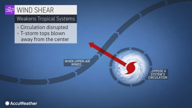
June is the time of the year in the tropical Atlantic when forecasters tend to watch for tropical development close to North America and Central America. This is due to vast areas of wind shear that make conditions too hostile for tropical storm formation elsewhere over much of the basin.
 |
Instead, most storms that develop this early in the season tend to form near old stalled fronts, non-tropical low-pressure areas or large weak circulations, known as gyres.
Tropical downpours and locally gusty thunderstorms have been pestering areas from the western Caribbean to near Bermuda in recent days. Activity along this zone of stormy weather will continue to vary in intensity for the next week or so.
Portions of Cuba and the central Bahamas have the potential to pick up 6-12 inches of rain through the middle of June. While the rain may help ease pockets of abnormally dry conditions, it may also pose problems. Downpours may not only interfere with outdoor activities - such as a day at the beach- but they may also trigger localized flash flooding. This could be especially problematic in mountainous terrain, where large volumes of water can funnel into narrow streams and valleys. Gusty winds in some of the thunderstorms may also create hazardous conditions for boating and fishing.
 |
Because this activity is occurring along an old, stalled front, there is a non-zero chance of tropical development in this zone over the next week or so, AccuWeather Lead Long-Range Meteorologist Paul Pastelok said.
"A strong argument against development from the western Caribbean to the northeast of the Bahamas is that strong wind shear will be present the whole time," Pastelok explained.
Breezes that blow from different directions or increase in strength over a particular zone are referred to collectively as wind shear. When wind shear is strong, it can interfere with tropical development or cause an established tropical system to lose wind intensity.
 |
Wind shear may be a significant factor in tropical development from the middle to the latter part of June as well in the same general area of the Atlantic basin.
A broad area of weak spin in the atmosphere that tends to form from the western Caribbean to waters over the eastern Pacific, known as the Central American Gyre, is likely to take shape around the middle of June, AccuWeather Tropical Meteorologist Alex DaSilva said.
"Toward the middle of the month, data suggests that barometric pressure will lower in the western Caribbean or southern Gulf of Mexico as the Central American Gyre becomes more active," DaSilva explained. "This gyre can enhance thunderstorms near Central America. The enhanced thunderstorm activity, combined with very high water temperatures, can potentially promote additional early-season tropical development."
 |
Some long-range forecasts suggest that a more compact low-pressure area will form in the western Caribbean, wander into the Gulf of Mexico and strengthen during the third or fourth week of June. However, this system's projected evolution may be too fast in reality.
"A tropical disturbance, referred to as a tropical wave, will make its way westward across the Atlantic during the third week of June, and it may be this system that tries to organize into more of an organized tropical system during the latter part of the month in the Caribbean," AccuWeather Long-Range Meteorologist Joe Bauer said.
"Water temperatures are very supportive of tropical storm formation in the western Caribbean and the southern Gulf of Mexico," Pastelok said.
A minimum temperature in the upper 70s F is needed for tropical development, but the water in the northwest Caribbean and the southern Gulf of Mexico is very warm, with temperatures currently in the mid-80s F.
 |
As of Sunday, June 11, 2023. |
"It will come down to whether strong wind shear relaxes or not from mid- to late June over this part of the Atlantic basin," Pastelok said.
"Data suggests that wind shear may back off over the Gulf during the third week of June," Pastelok said.
If wind shear eases in this area, then there could be a tropical concern for the United States later this month.
The next named storm system in the Atlantic will be known as Bret.
Occasionally, tropical development as a result of the Central America gyre occurs in the eastern Pacific instead of the Caribbean or Gulf side. This is also a possibility as well as the remote chance of development in both the eastern Pacific and Atlantic basins later this month.
There have been no tropical systems in the eastern Pacific so far in 2023. The first name on the list of tropical storms for this year in the basin is Adrian.
Want next-level safety, ad-free? Unlock advanced, hyperlocal severe weather alerts when you subscribe to Premium+ on the AccuWeather app. AccuWeather Alerts™ are prompted by our expert meteorologists who monitor and analyze dangerous weather risks 24/7 to keep you and your family safer.
