Cyclone Mocha strengthens as it churns over Bay of Bengal


The Bay of Bengal's first named tropical cyclone of the season, Mocha, formed Thursday morning, local time, and AccuWeather meteorologists say the strengthening storm could bring significant impacts to land as early this weekend.
Residents and visitors from Bangladesh to Myanmar are urged to begin preparations ahead of Cyclonic Storm Mocha's forecast landfall near the border of these two countries. The cyclone's wind strength may be comparable to a Category 2 or Category 3 hurricane (maximum sustained winds of 96-129 mph or 155-210 km/h) on the Saffir-Simpson Hurricane Wind Scale by the time it reaches land.
As of Friday afternoon, local time, Mocha was classified as a "very severe cyclonic storm," by the India Meteorological Department (IMD) and packed maximum sustained winds near 75 mph (120 km/h), with gusts to 85 mph (135 km/h). Additional strengthening is expected into Saturday.
 |
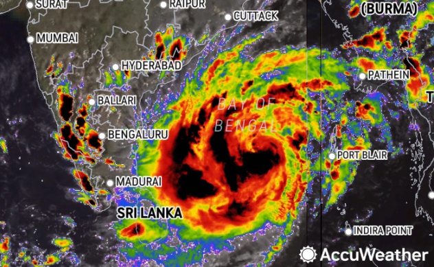
Cyclone Mocha on AccuWeather's Wind Flow Map Thursday afternoon local time. |
Mocha is the first cyclone of the year in the Bay of Bengal. The last named storm to prowl these waters was Mandous in December 2022. Mandous made landfall in southeastern India early that month.
AccuWeather Lead International Forecaster Jason Nicholls and his team of international forecasting experts at AccuWeather has been discussing the potential for early May tropical activity in the Bay of Bengal since April 27.
Mocha is expected to take a general track to the north-northwest before it makes a turn toward the northeast on Friday. This path will spare India from direct impacts but not countries farther to the east.
 |
"Mocha can make landfall as a very severe cyclonic storm in northwestern Myanmar or adjacent Bangladesh Saturday night or Sunday, local time, with flooding rain and damaging winds likely in these areas," Nicholls said.
AccuWeather meteorologists cannot rule out the possibility that the future cyclone could reach "extremely severe cyclonic storm" status prior to landfall, given the conducive conditions for strengthening over the Bay of Bengal. Sea surface temperatures in the path of the storm are generally around 88 degrees Fahrenheit (31 degrees Celsius), which is well above the 80-degree-Fahrenheit (27-degree-Celsius) threshold for tropical cyclone strengthening.
Seas across the central and eastern Bay of Bengal will turn increasingly dangerous for shipping interests as the storm churns over the region.
 |
Storm surge flooding can inundate coastal communities to the north and east of where the center of the storm crashes ashore, with the high water levels putting lives and property at risk.
A tropical deluge will accompany the storm, according to Nicholls, and rainfall totals could eclipse a foot (305 mm) across some of the mountainous areas. That much rain falling over steep terrain will significantly raise the risk of flash flooding and landslides.
AccuWeather forecasters warn that tree damage, power outages and structural damage can all occur in the storm's fierce winds, with the greatest risk of damage being near the center of the storm.
The storm is expected to unravel over land early next week, and there are no signs of other immediate tropical threats in its wake, forecasters say.
Want next-level safety, ad-free? Unlock advanced, hyperlocal severe weather alerts when you subscribe to Premium+ on the AccuWeather app. AccuWeather Alerts™ are prompted by our expert meteorologists who monitor and analyze dangerous weather risks 24/7 to keep you and your family safer.
