AccuWeather forecasters tracking potential for derechos in central, southern US into next week


AccuWeather meteorologists are growing concerned that one or more long-lived, highly damaging thunderstorm events, known as derechos, will occur over portions of the Great Plains to the southeastern United States into this weekend and perhaps into next week as well.
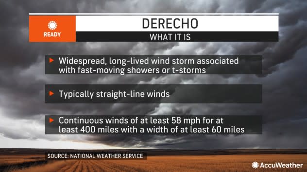
The term derecho derives from the Spanish language and means "straight ahead" when translated into English. In meteorology, the word is used to describe a powerful complex of thunderstorms that tends to race along at high-speed for hundreds of miles and produce damaging straight-line wind gusts.
The official scientific criteria of a derecho, as described by the National Weather Service's Storm Prediction Center, pertains to the swath of wind damage that must extend either continuously or intermittently for more than 400 miles with a width of at least 60 miles.
 |
AccuWeather meteorologists maintain that whether or not the official criteria are reached during or following an investigation after the event, there is still the potential for widespread damaging wind gusts with significant risk to lives and property when the term is raised as a forecast.
Powerful, long-lived thunderstorm complexes such as derechos can behave very much like inland hurricanes and can cause substantial property damage, major travel disruptions, widespread power outages and, most importantly, dangerous and life-threatening conditions.
Key atmospheric signals for derechos or strong thunderstorm complexes will be present from portions of the southern and central Plains to the Southeast through this weekend and into next week, AccuWeather Senior Long-Range Meteorologist Joe Lundberg said.
"There will be a building dome of heat centered on Texas, initially, a nearly stationary storm over the eastern U.S., and a strong jet stream that extends from northwest to southeast over the region," Lundberg explained.
 |
"As the heat dome pushes northward, disturbances in the jet stream will kick off rounds of thunderstorms that will repeat multiple times," Lundberg added. "The thunderstorms tend to erupt on the rim of the heat."
While not all thunderstorms will be created equal in the pattern, and some storms may track farther north or south than others, there is the potential for one or more derechos to develop and travel long distances.
The air in Texas and along the Gulf Coast is not only hot but also very humid, and that will provide plenty of fuel for the thunderstorms as they grow, Lundberg said.
A complex of severe thunderstorms that developed on Thursday night may continue on toward the central Gulf coast through Friday night or perhaps new complexes of storms may form over the lower Mississippi Valley during the daylight hours on Friday.
The thunderstorm complexes will be capable of unleashing damaging winds, large hail, frequent lightning strikes and flash flooding. Although the top speed of the wind gusts in the strongest storms may vary from day to day, AccuWeather Local StormMax™ wind gusts will range from 80 to 90 mph and could end up as high as 100 mph.
 |
A small number of tornadoes may also be spawned by some of the storms.
Following the risk of intense thunderstorms and a possible derecho from parts of Arkansas and Louisiana to Georgia through Friday night, the derecho risk will continue over portions of the central and southern Plains Saturday, according to data AccuWeather meteorologists were monitoring Thursday.
The Saturday to Saturday night event could evolve into the most intense complex of storms of the entire pattern and potentially end up being one of the most notable severe weather outbreaks of the season.
 |
However, the exact position, timing and intensity of that thunderstorm complex or line of storms that develop will depend on the movement of a disturbance that rolls out from the Rockies to end this week.
The risk of severe weather will likely then continue on into the Southeastern states on Sunday as the complex of storms from Saturday continues to race along.
 |
AccuWeather experts advise that people living in pre-manufactured homes pay special attention to bulletins as they are issued and seek refuge in a designated storm-safe building when necessary during the pattern. Pre-manufactured homes are highly susceptible to damage from high winds and falling trees. Since the threat for thunderstorms packing high winds will continue well past dark in some cases, the danger factor may increase.
"While the heat dome will remain across the center of the country early next week, disturbances may not eject from the Rockies as often, which may slow the pace of severe weather in the region," said AccuWeather Senior Meteorologist Adam Douty.
 |
Storms over the Southeast may continue to erupt and repeat with more rounds of heavy and even severe thunderstorms capable of producing gusty winds, torrential rain and a flash flood risk.
Heavy storms that develop and target the same parts of the Southeast next week, including parts of Alabama, Georgia, Mississippi and Florida, could potentially unload 6-12 inches of rain. Rainfall of this magnitude may lead to urban flooding as well as flash flooding of small streams. Water levels on secondary rivers could rise.
Any downturn in severe thunderstorm activity across portions of the central and southern Plains next week may not last.
"The pattern may once again become more favorable for severe thunderstorm complexes in the center of the U.S. later next week as a storm system moves from the Northwest into the Plains," Douty said.
The area from the Great Plains to the Mississippi Valley is a hot spot for long-lived thunderstorm complexes such as derechos. The overall weather pattern may continue to favor such activity, perhaps into the end of the month.
Want next-level safety, ad-free? Unlock advanced, hyperlocal severe weather alerts when you subscribe to Premium+ on the AccuWeather app. AccuWeather Alerts™ are prompted by our expert meteorologists who monitor and analyze dangerous weather risks 24/7 to keep you and your family safer.
