AccuWeather forecasters tracking tropical waves emerging from Africa


As Tropical Storm Don continues to churn over the open waters of the Atlantic, AccuWeather meteorologists will be closely monitoring the zone from Africa to Florida for additional tropical development over the next 10 to 14 days. A change in the weather pattern could lead to a spark in activity, forecasters say.
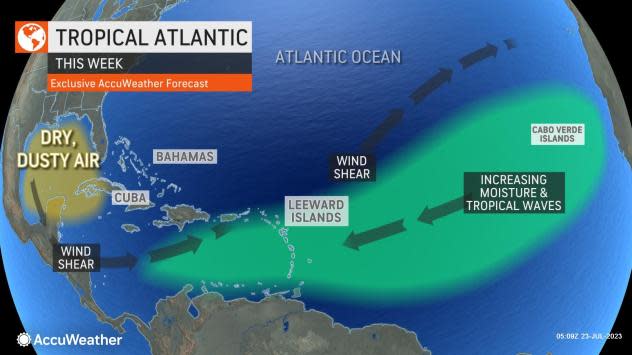
The period from July to early August is typically a quiet time for tropical activity in the Atlantic. The basin often remains devoid of tropical storms during the middle of summer due to several factors, including a harsh environment of extensive dry air and disruptive winds that meteorologists refer to as wind shear.
Tropical development typically increases significantly in August as the heart of the hurricane season begins during the middle of the month and continues into the fall.
 |
This wide image of the Atlantic was captured on Saturday, July 22, 2023. Don can be seen near the upper part of the image and tropical waves were visible moving off of Africa (lower right). The candidate for tropical development was located in the lower center of the image. (AccuWeather RealView™ satellite) |
Just last year, there were no named storms in the Atlantic during the entire month of August for the first time in 25 years. However, a change in the weather pattern should make that unlikely to occur again. AccuWeather meteorologists say that the zone well south of where Don is spinning in the middle of the basin is the corridor to watch as a series of tropical disturbances, called tropical waves, move along just north of the equator.
The tropical wave train has been stronger than usual this season and helped to give birth to tropical storms Bret and Cindy in June, forecasters explain.
This key development region has been strewn with dry air and strong wind shear this past week, preventing any systems from becoming better organized. But both of those inhibiting factors are already showing signs of waning.
A tropical wave located roughly midway between the Cabo Verde Islands and the Lesser Antilles as of Saturday will encounter more favorable conditions. While this may not be a contender for becoming a strong system, it may pave the way for other disturbances that follow.
"This tropical wave is in a pocket where wind shear has dropped off with some moisture," AccuWeather Chief On-Air Meteorologist Bernie Rayno said. "Because of these factors, there is a chance of organization and some low-end development early this week."
AccuWeather meteorologists are giving this tropical wave a low chance for development between July 23-25. The next named storm in the Atlantic will be Emily.
 |
Rayno pointed out that as this system moves farther to the west, near the Windward and Leeward Islands by the middle of the week, it is likely to encounter stronger wind shear, lose wind intensity and could even fall apart. The system may also ingest dry air as it tracks to the west.
However, as more tropical waves continue to roll westward from Africa in the wake of this system, there is a chance that wind shear will remain low enough and there will be enough moisture to allow a budding tropical system to develop.
As more of these waves travel farther to the west, one or more may hold together enough to organize near the Caribbean in late July and early August, AccuWeather Lead Long-Range Meteorologist Paul Pastelok said.
Waters are incredibly warm in the Caribbean and surrounding much of the Florida Peninsula and range from the mid-80s Fahrenheit to near 90 with pockets of even warmer conditions.
 |
The water temperature threshold that can sustain tropical development is in the upper 70s to near 80 degrees. So any disturbance that wanders over the warm water, provided wind shear is low and the air is moist, has a chance of ramping up.
"One such tropical wave may be in a better spot for development from the northern islands of the Caribbean to Florida and the Bahamas during the first few days of August," Pastelok said.
"The large land masses of Cuba and Hispaniola may be enough to hinder significant development, but long-range data suggests that a weak system, such as a depression or storm with drenching rain, is not totally out of the question in waters surrounding the islands to Florida in early August," Pastelok added.
Pastelok added that a westward extension of high pressure over the Atlantic may tend to prevent any weak system from turning northward and recurving east of the Atlantic coast of the United States.
 |
Don, which was initially classified as a subtropical storm when it formed on July 14, briefly became the first hurricane of the 2023 Atlantic season on Saturday, July 22 over the open North Atlantic. Don has since lost wind intensity over cooler waters and is now a Tropical Storm once again.
Don will not be a threat to land, AccuWeather forecasters say.
Don surpassed Bret as the storm with the most Accumulated Cyclone Energy (ACE) so far in the 2023 Atlantic season, according to data from Colorado State University. The 2023 season is also pacing ahead of the historical average when it comes to ACE, which is a metric forecasters use to quantity both an individual storm's intensity and the collective intensity for all storms that roam the basin.
The next two named storms that form in the Atlantic will be called Emily and Franklin. In addition to Don, Cindy and Bret, Tropical Storm Arlene formed in early June but faded quickly over the Gulf of Mexico. There was also an unnamed subtropical storm that formed over the North Atlantic in the middle of January.
AccuWeather meteorologists predicted 11 to 15 named storms and four to eight hurricanes when they issued their initial forecast back in March.
 |
Want next-level safety, ad-free? Unlock advanced, hyperlocal severe weather alerts when you subscribe to Premium+ on the AccuWeather app. AccuWeather Alerts™ are prompted by our expert meteorologists who monitor and analyze dangerous weather risks 24/7 to keep you and your family safer.
