AccuWeather's NYC summer forecast: Hot weather, plenty of beach days expected


 |
A morning commuter sits on a bench at the ferry terminal in Jersey City, N.J. looking at the lower Manhattan skyline on a cloudless day in New York City, Thursday, Aug. 18, 2022. (AP Photo/J. David Ake) |
Following some bouts of cool air during May, the summer of 2023 in New York City will emerge with an above-average number of hot days with the warmest and driest part of the summer likely to be August, according to AccuWeather's team of long-range meteorologists.
Temperatures are expected to average 1.5 to 2.5 degrees Fahrenheit above the historical average from June 1 through Aug. 31, near to slightly higher than in 2022 when temperatures during meteorological summer averaged 1.6 degrees above the historical average. However, while this alone should translate to good beach weather, what exactly does that mean in terms of the magnitude of warmth?
Daytime highs typically trend quickly upward from the mid-70s in June to the mid-80s during early July and remain well into the 80s throughout the month. During August, high temperatures slowly trend back toward the lower 80s as the nights become longer.
 |
Some of the threats and concerns highlighted by AccuWeather meteorologists for the upcoming summer season. |
Most summers bring temperature swings above and below this historical average curve, but this summer may be remembered for surges in heat.
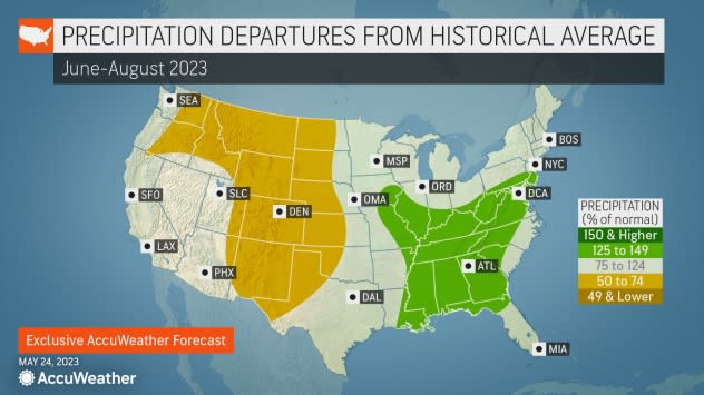
Portions of the Northeast were so dry in May that pockets of abnormally dry conditions showed up on the U.S. Drought Monitor map by the end of May, and drier weather is expected to persist into the first part of June. When the air and ground are dry, the atmosphere behaves like a desert promoting warmer days and cooler nights.
"That dry air and its effect on the landscape combined with intense sunshine will have an effect on high temperatures during June," AccuWeather Lead Long-Range Meteorologist Paul Pastelok said. "This can result in brief hot streaks."
There have already been a couple of days with highs at or above 90 F in mid-April, associated with a stretch of dry weather. On average, the first 90-degree day does not occur in New York City until June 2.
The city typically has about 17 days a year when temperatures reach the 90-degree mark or higher, with 13 of those days typically occurring during the stretch from June through August. Because of the above-average warmth anticipated, there is a high chance for the city to exceed the average number of days with 90-degree temperatures this year.
AccuWeather is projecting between 18 and 22 days with highs of 90 degrees or more in 2023. Given the number of hot days and above-historical-average warmth expected this summer, cooling demands will be above average as well.
 |
Last year, there were 25 days with high temperatures of 90 or higher in New York City with 21 of the occurrences happening in July and August. Several decades ago, throughout 1991 and again in 1993, there were a record total of 39 days with 90-degree temperatures or higher.
With the dryness playing a role during the first part of June, the city has a decent chance of squeezing in some 90-degree weather during the first third of the unofficial summer season. Until humidity levels surge on a consistent basis, the few 90-degree days that occur may not feel like the middle of the summer.
"Sometime during the latter part of week two or during week three of June, a Bermuda high is likely to develop in the western Atlantic, which should allow for a more humid pattern," AccuWeather Meteorologist Brandon Buckingham said. "As humidity levels trend upward, the nights will become more uncomfortable for those without air conditioning."
AccuWeather's long-range team believes that some routine rainfall by way of showers or thunderstorms will return to the New York metro area during the second half of June and continue through much of July.
 |
"There are likely to be multiple fronts that move through the region from mid-June through much of July and while that may not bring frequent rain and widespread flooding, it could result in average rainfall for the period and roll back building dryness and heat potential from the spring," Pastelok said. Any summertime thunderstorm downpour has the potential to bring brief, localized urban flooding.
The return of moisture into the ground may help even out temperature spikes and could be enough to result in average to below-average numbers of 90-degree days. However, there can still be brief surges in heat and high humidity ahead of the fronts, Pastelok said.
"While severe thunderstorm activity is likely to occur on a few days during the summer in New York City, the bulk of the storms may hold up over the Midwest, Appalachians and farther south in the mid-Atlantic region," Pastelok said.
 |
AccuWeather meteorologists say that predominantly dry conditions will return to the New York City area during August - and temperatures may respond in a big way.
"Because of extensive dryness anticipated, August should bring a bumper crop of hot days in New York City," Pastelok said. The pattern could bring much more than the historical average of 90-degree weather for the month. Typically, there are four days with highs at or above 90 in August.
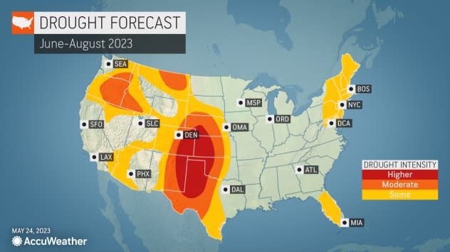
"With the cycle of heat and dryness during August, there is a chance of building drought for the area, heading into the fall season," Pastelok said.
 |
Atlantic Ocean water temperatures were still above the historical average during late May, and that should continue well into the summer. Surf temperatures ranged from the upper 50s to the mid-60s during the Memorial Day weekend. The warm coastal waters will contribute to some great days at the beach, with air temperatures at levels above historical averages. However, the warm waters should not yield a surge of tropical activity along the upper mid-Atlantic coast.
As an El Niño pattern evolves, most of tropical systems that form through the end of the summer and perhaps into the fall should stay south of the upper mid-Atlantic region, Pastelok said.
During an El Niño, jet stream winds over North America tend to reach across a large part of the Atlantic and create wind shear, which acts as a deterrent for tropical activity.
GET THE FREE ACCUWEATHER APP
• Have the app? Unlock AccuWeather Alerts™ with Premium+
There are likely to be colorful sunrises and sunsets at times throughout the summer, as has been the case this spring.
"Numerous large wildfires have been burning in western Canada this spring and are likely to continue through much of the summer," Pastelok said. "Jet stream winds high in the atmosphere will periodically continue to carry the smoke from the fires thousands of miles to the east." In recent weeks, smoke from fires in Atlantic Canada has been drifting into the northeastern U.S. as well.
The high-flying smoke may cause the sky overhead to appear hazy at times on certain days, even when the humidity is low. The smoke will contribute to orange, red and purple hues in the sky when the sun is near the horizon. It may be possible for some of the smoke to reach down near the ground in the form of haze and poor air quality.
Want next-level safety, ad-free? Unlock advanced, hyperlocal severe weather alerts when you subscribe to Premium+ on the AccuWeather app. AccuWeather Alerts™ are prompted by our expert meteorologists who monitor and analyze dangerous weather risks 24/7 to keep you and your family safer.
