Ice storm looms for southeastern US


As a new wave of Arctic air settles in late this week, a winter storm with snow and ice could cause major travel disruptions across the southeastern United States. AccuWeather forecasters are warning that the system could take aim at the Northeast next, but they are still analyzing different scenarios that may unfold.
The fresh injection of Arctic air, which will come right on the heels of another dose of wintry weather, is likely to penetrate deep into the South. A bigger winter storm than the midweek one is expected to develop along the leading edge of bitter air.
 |
The storm's strength will be a factor not only in how quickly it will move along, but also in the intensity and type of wintry precipitation it delivers from northern and central Georgia to the Carolinas and southeastern Virginia. Ultimately, the storm's strength and track will also play a role in determining how it will impact the coastal Northeast: There's a chance a major snowstorm could unfold or, depending on how the storm develops, the region could end up with just a dusting of snow.
If the storm strengthens quickly, then it will be more likely to move slowly and track a bit farther to the north across the South, unleashing heavy precipitation. This scenario could result in heavy snow along much of the Interstate 85 corridor from near Atlanta to Charlotte, North Carolina, and Richmond, Virginia, Friday into Saturday morning. Farther south, significant sleet and freezing rain could occur from southeast of I-85 to near I-95 in the Southeast.
 |
On the other hand, if the storm is on the weaker side, it will be pushed eastward by strong jet stream winds. In that setup, light to moderate snow would likely develop along the I-85 corridor, and snow and ice could extend all the way to the Carolina coast in the same time frame.
CLICK HERE FOR THE FREE ACCUWEATHER APP
AccuWeather meteorologists say that people who live or travel through areas from Georgia to the Carolinas and Virginia should prepare for another significant winter storm that will cover roads, create dangerous travel conditions and cause power outages for tens of thousands of customers. Airline passengers should expect a slew of flight cancellations at the major southern hubs of Atlanta and Charlotte from Friday to Saturday.
 |
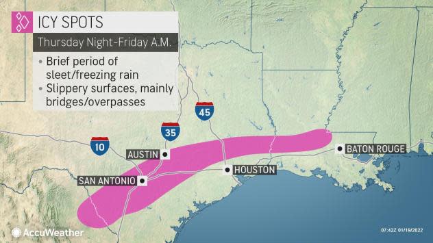
A narrow zone of sleet and freezing rain can occur as Arctic air plunges southward along the I-10 corridor later Thursday night and Friday morning.
The icy precipitation is likely to be spotty and light, but even an ultra-thin glaze can lead to very dangerous conditions on the highways, such as the case last February in the Fort Worth, Texas, area. Fort Worth is expected to dodge this potential icing event this time. The risk of a spotty glaze of ice will extend from near Houston and San Antonio, Texas, to parts of central Louisiana, southern Mississippi, central Alabama and western and central Georgia from late Thursday night to early Friday, AccuWeather Storm Warning Meteorologist Alexis Masse said.
 |
Roads and sidewalks could be just wet in some neighborhoods and along some stretches of highways, but conditions could be icy in other areas such as elevated surfaces, including bridges and overpasses.
There are a range of possibilities that AccuWeather forecasters are weighing once the storm reaches the Northeast.
Even a weak storm would allow some light snow to spread northward into the mid-Atlantic and central Appalachians Saturday and then New England Sunday before strong westerly jet stream winds kick in and sweep the moisture out to sea.
 |
However, if trends continue to point toward a stronger storm developing, then areas along the I-95 corridor of the mid-Atlantic and New England could be in for not only travel-snarling snow, but also a storm that could bury many locations under a foot or more of powdery snow. Blowing and drifting of snow could occur due to gusty winds in that scenario, adding to the hazards.
 |
"Most of the time when there is a fresh injection of cold air associated with high pressure that builds across New England, a major storm follows for the Northeast," AccuWeather Chief On-Air Meteorologist Bernie Rayno said, adding that this setup will be in place again this time around.
If that stronger storm scenario is correct, then heavy snow will spread northward in Virginia during Friday night and then envelop much of the upper mid-Atlantic region Saturday and southeastern New England Saturday night. Cities such as Washington, D.C., Baltimore, Philadelphia, New York City and Boston could be hammered with snow. However, AccuWeather forecasters believe that this scenario is becoming less likely. Some snow would still extend northwestward to parts of the central Appalachians and northern New England, but a sharp cutoff to the snow might develop due to the coastal storm.
Even a solution somewhere in between the two possibilities would bring accumulating snow to the big cities along I-95 in the Northeast, leading to travel delays associated with slippery roads and deicing operations at the major airport hubs.
Given the magnitude of the cold air ahead of the storm, should it move northward and just off the coast mid-Atlantic, the primary form and perhaps all of the precipitation would fall as snow along I-95 in the Northeast. Beach areas may receive snow but with some mixing of sleet and perhaps rain.
Unlike the storm from last weekend, the storm brewing for this weekend is not expected to produce heavy snow west of the Appalachians such as areas in the Ohio Valley and the eastern Great Lakes region. Outside of any localized lake-effect snow, most areas may be dry while a storm hammers away at the coast.
For the latest weather news check back on AccuWeather.com. Watch the AccuWeather Network on DIRECTV, Frontier, Spectrum, fuboTV, Philo, and Verizon Fios. AccuWeather Now is now available on your preferred streaming platform.
